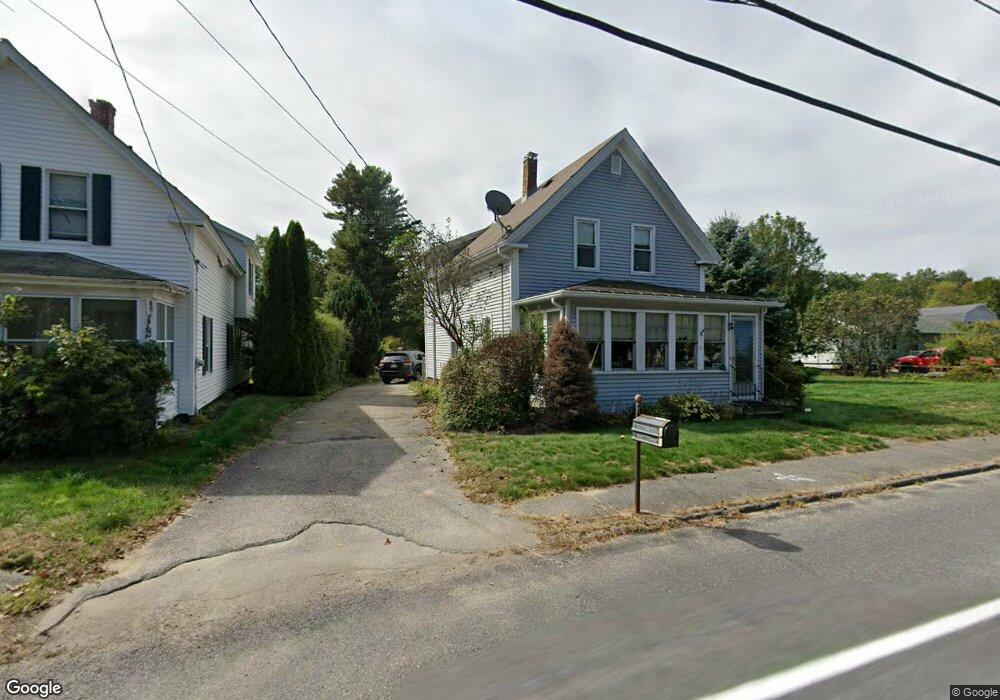
14 Sterling St Lancaster, MA 01523
Estimated Value: $419,755 - $493,000
3
Beds
1
Bath
1,450
Sq Ft
$303/Sq Ft
Est. Value
About This Home
This home is located at 14 Sterling St, Lancaster, MA 01523 and is currently estimated at $439,939, approximately $303 per square foot. 14 Sterling St is a home located in Worcester County with nearby schools including Mary Rowlandson Elementary School, Luther Burbank Middle School, and Nashoba Regional High School.
Ownership History
Date
Name
Owned For
Owner Type
Purchase Details
Closed on
Nov 21, 1996
Sold by
Malanson Emma G Est
Bought by
Soar Donald B and Soar Nancy C
Current Estimated Value
Home Financials for this Owner
Home Financials are based on the most recent Mortgage that was taken out on this home.
Original Mortgage
$99,810
Interest Rate
7.81%
Mortgage Type
Purchase Money Mortgage
Create a Home Valuation Report for This Property
The Home Valuation Report is an in-depth analysis detailing your home's value as well as a comparison with similar homes in the area
Home Values in the Area
Average Home Value in this Area
Purchase History
| Date | Buyer | Sale Price | Title Company |
|---|---|---|---|
| Soar Donald B | $110,900 | -- |
Source: Public Records
Mortgage History
| Date | Status | Borrower | Loan Amount |
|---|---|---|---|
| Open | Soar Donald B | $105,750 | |
| Closed | Soar Donald B | $99,810 |
Source: Public Records
Tax History Compared to Growth
Tax History
| Year | Tax Paid | Tax Assessment Tax Assessment Total Assessment is a certain percentage of the fair market value that is determined by local assessors to be the total taxable value of land and additions on the property. | Land | Improvement |
|---|---|---|---|---|
| 2025 | $5,011 | $310,100 | $105,400 | $204,700 |
| 2024 | $5,257 | $301,100 | $96,100 | $205,000 |
| 2023 | $4,688 | $272,700 | $87,400 | $185,300 |
| 2022 | $4,617 | $237,400 | $81,200 | $156,200 |
| 2021 | $4,442 | $222,300 | $81,200 | $141,100 |
| 2020 | $4,278 | $215,500 | $81,200 | $134,300 |
| 2019 | $4,086 | $206,900 | $81,200 | $125,700 |
| 2018 | $3,956 | $198,000 | $81,200 | $116,800 |
| 2016 | $3,707 | $189,600 | $80,300 | $109,300 |
| 2015 | $3,566 | $190,100 | $80,300 | $109,800 |
| 2014 | $2,984 | $157,800 | $80,300 | $77,500 |
Source: Public Records
Map
Nearby Homes
- 19 Magnolia Ave
- 51 Rigby St
- 54 S Meadow Rd
- 290 Sterling St
- 22 Forest Ave
- 1 Grady St
- 55 Sterling St Unit 306
- 55 Sterling St Unit 314
- 55 Sterling St Unit 212
- 0 Parker Rd
- 57 Clark St
- 201-203 Stone St
- 201 Stone St Unit 203
- 23 Ash St
- 53 Beach Point Rd
- 1116 George Hill Rd
- 216 Walnut St
- 89 1/2 Walnut St
- 38 Lane Ave Unit B
- 13 Simon Ct
- 8 Sterling St
- 26 Sterling St
- 9 Sterling St
- 368 Sterling St
- 3 Sterling St
- 3 Sterling St Unit 3 Sterling
- 31 Sterling St
- 36 Sterling St
- 366 Sterling St
- 385 Sterling St
- 1 Willow St
- 37 Sterling St
- 3 Willow St
- 364 Sterling St
- 5 Willow St
- 365 Sterling St
- 23 Silver St
- 47 Sterling St
- 359 Sterling St
- 50 Sterling St