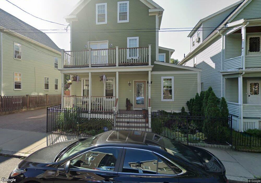
14 Thorndike St Somerville, MA 02144
Davis Square NeighborhoodEstimated Value: $1,699,000 - $2,001,976
3
Beds
3
Baths
3,030
Sq Ft
$610/Sq Ft
Est. Value
About This Home
This home is located at 14 Thorndike St, Somerville, MA 02144 and is currently estimated at $1,849,494, approximately $610 per square foot. 14 Thorndike St is a home located in Middlesex County with nearby schools including Somerville High School, St. Clement Elementary School, and Cambridge Friends School.
Ownership History
Date
Name
Owned For
Owner Type
Purchase Details
Closed on
Aug 1, 2011
Sold by
Bao Yi and He Siyuan
Bought by
Burch Philip D and Ballard Alison E
Current Estimated Value
Purchase Details
Closed on
Jul 30, 2010
Sold by
Moro Patricia and Landers Irene
Bought by
Bao Yi and He Siyuan
Create a Home Valuation Report for This Property
The Home Valuation Report is an in-depth analysis detailing your home's value as well as a comparison with similar homes in the area
Home Values in the Area
Average Home Value in this Area
Purchase History
| Date | Buyer | Sale Price | Title Company |
|---|---|---|---|
| Burch Philip D | $949,900 | -- | |
| Bao Yi | $610,000 | -- |
Source: Public Records
Tax History
| Year | Tax Paid | Tax Assessment Tax Assessment Total Assessment is a certain percentage of the fair market value that is determined by local assessors to be the total taxable value of land and additions on the property. | Land | Improvement |
|---|---|---|---|---|
| 2025 | $19,232 | $1,762,800 | $0 | $1,762,800 |
| 2024 | $17,754 | $1,687,600 | $0 | $1,687,600 |
| 2023 | $17,634 | $1,705,400 | $0 | $1,705,400 |
| 2022 | $16,861 | $1,656,300 | $0 | $1,656,300 |
| 2021 | $16,533 | $1,622,500 | $0 | $1,622,500 |
| 2020 | $16,031 | $1,588,800 | $0 | $1,588,800 |
| 2019 | $15,509 | $1,441,400 | $0 | $1,441,400 |
| 2018 | $14,807 | $1,309,200 | $0 | $1,309,200 |
| 2017 | $14,637 | $1,254,200 | $0 | $1,254,200 |
| 2016 | $14,247 | $1,137,000 | $0 | $1,137,000 |
| 2015 | $12,302 | $975,600 | $0 | $975,600 |
Source: Public Records
Map
Nearby Homes
- 17 Holland St Unit 301
- 34 Elmwood St Unit 2
- 1004 Broadway Unit 3
- 7A Meacham Rd Unit 7A
- 5 Glendale Ave Unit 5
- 2353 Massachusetts Ave Unit 44
- 68 Winslow Ave
- 2 Gold Star Ct
- 30 Clarendon Ave
- 371 Highland Ave
- 42 Packard Ave Unit 42
- 69 Electric Ave Unit 3
- 69 Electric Ave Unit 1
- 97 Elmwood St Unit 313
- 97 Elmwood St Unit 110
- 97 Elmwood St Unit 310
- 55 Packard Ave Unit 1
- 353 Summer St Unit 310
- 7 Russell St Unit 1
- 3 Warwick Park Unit 2
- 12 Thorndike St
- 10 Thorndike St
- 16 Thorndike St
- 68 Holland St
- 20 Thorndike St Unit 2
- 20 Thorndike St
- 70 Holland St Unit 2
- 74 Holland St
- 24 Thorndike St Unit 1
- 13 Thorndike St Unit 2
- 11 Thorndike St
- 11 Thorndike St Unit 2
- 15 Thorndike St
- 15 Thorndike St Unit 1
- 22 Thorndike St
- 5 Thorndike St
- 7 Thorndike St
- 17 Thorndike St
- 3 Thorndike St
- 80 Holland St Unit 2
Your Personal Tour Guide
Ask me questions while you tour the home.