K
Seller's Agent in 2025
Kyle Pacia
Compass
(401) 374-6046
1 in this area
41 Total Sales
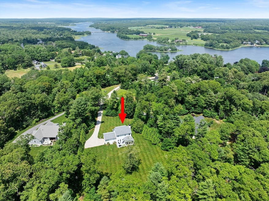


CUSTOM-BUILT HOME | LIKE-NEW CONDITION – Everything is done to perfection in this move-in ready gem. Designed for relaxed, nature-inspired coastal living, this Craftsman-style home with Hardiplank siding offers 360-degree privacy on professionally-landscaped grounds with mature plantings. With space for a pool on 3 acres, the property features a composite 3-season porch, back deck, outdoor shower, & front farmers’ porch. Inside, enjoy abundant light, an open floor plan, 7” engineered white oak floors, gas fireplace, gourmet kitchen w/ a walk-in pantry, built-in breakfast nook, & high-end KitchenAid appliances. The first floor features a guest room & full bath. On the second level, the spacious primary suite boasts a huge walk-in closet, dual shower head walk-in shower, & 6' soaking tub. A third bedroom & oversized laundry room complete the second level. Just 5 mins to Cherry & Webb Beach, Westport Rivers Vineyard, Central Village, Buzzards Bay Brewery, hiking trails, & Rte 88.
| Date | Type | Sale Price | Title Company |
|---|---|---|---|
| Deed | $1,255,000 | -- | |
| Deed | $1,255,000 | -- | |
| Quit Claim Deed | -- | None Available |
| Date | Status | Loan Amount | Loan Type |
|---|---|---|---|
| Previous Owner | $585,000 | Stand Alone Refi Refinance Of Original Loan | |
| Previous Owner | $588,000 | New Conventional | |
| Previous Owner | $51,000 | Unknown | |
| Previous Owner | $64,000 | Credit Line Revolving |
| Date | Event | Price | Change | Sq Ft Price |
|---|---|---|---|---|
| 08/05/2025 08/05/25 | Sold | $1,255,000 | +14.2% | $594 / Sq Ft |
| 07/12/2025 07/12/25 | Pending | -- | -- | -- |
| 07/01/2025 07/01/25 | For Sale | $1,099,000 | -- | $520 / Sq Ft |
| Year | Tax Paid | Tax Assessment Tax Assessment Total Assessment is a certain percentage of the fair market value that is determined by local assessors to be the total taxable value of land and additions on the property. | Land | Improvement |
|---|---|---|---|---|
| 2025 | $5,266 | $706,900 | $322,600 | $384,300 |
| 2024 | $5,233 | $677,000 | $301,400 | $375,600 |
| 2023 | $5,209 | $638,300 | $288,700 | $349,600 |
| 2022 | $5,072 | $598,100 | $288,700 | $309,400 |
| 2021 | $4,585 | $531,900 | $222,500 | $309,400 |
| 2020 | $4,440 | $526,700 | $200,900 | $325,800 |
| 2019 | $4,292 | $519,000 | $200,900 | $318,100 |
| 2018 | $2,887 | $353,400 | $197,900 | $155,500 |
| 2017 | $2,125 | $266,600 | $266,600 | $0 |
| 2016 | $1,002 | $126,700 | $126,700 | $0 |
K
Seller's Agent in 2025
Kyle Pacia
Compass
(401) 374-6046
1 in this area
41 Total Sales

Buyer's Agent in 2025
Jennifer Hilton
Keller Williams Coastal
(401) 787-3173
1 in this area
96 Total Sales
Source: MLS Property Information Network (MLS PIN)
MLS Number: 73398856
APN: WPOR-000056A-000000-000028F
Disclaimer: Certain information contained herein is derived from information provided by parties other than Homes.com. All information provided is deemed reliable, but is not guaranteed to be accurate and should be independently verified.
![]() The property listing data and information, or the Images, set forth herein were provided to MLS Property Information Network, Inc. from third party sources, including sellers, lessors and public records, and were compiled by MLS Property Information Network, Inc. The property listing data and information, and the Images, are for the personal, non-commercial use of consumers having a good faith interest in purchasing or leasing listed properties of the type displayed to them and may not be used for any purpose other than to identify prospective properties which such consumers may have a good faith interest in purchasing or leasing. MLS Property Information Network, Inc. and its subscribers disclaim any and all representations and warranties as to the accuracy of the property listing data and information, or as to the accuracy of any of the Images, set forth herein.
The property listing data and information, or the Images, set forth herein were provided to MLS Property Information Network, Inc. from third party sources, including sellers, lessors and public records, and were compiled by MLS Property Information Network, Inc. The property listing data and information, and the Images, are for the personal, non-commercial use of consumers having a good faith interest in purchasing or leasing listed properties of the type displayed to them and may not be used for any purpose other than to identify prospective properties which such consumers may have a good faith interest in purchasing or leasing. MLS Property Information Network, Inc. and its subscribers disclaim any and all representations and warranties as to the accuracy of the property listing data and information, or as to the accuracy of any of the Images, set forth herein.