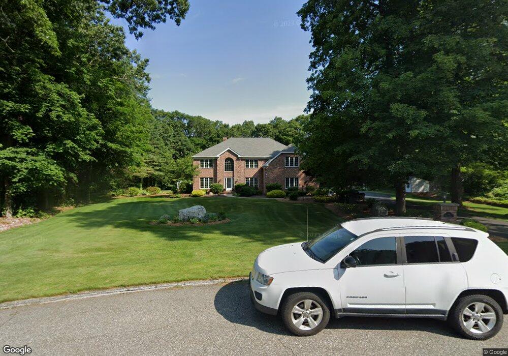
14 Wagon Dr Wilbraham, MA 01095
Estimated Value: $952,498 - $1,335,000
5
Beds
5
Baths
4,866
Sq Ft
$228/Sq Ft
Est. Value
About This Home
This home is located at 14 Wagon Dr, Wilbraham, MA 01095 and is currently estimated at $1,111,375, approximately $228 per square foot. 14 Wagon Dr is a home located in Hampden County with nearby schools including Minnechaug Regional High School and Wilbraham & Monson Academy.
Ownership History
Date
Name
Owned For
Owner Type
Purchase Details
Closed on
Mar 10, 2025
Sold by
Fuss Kathleen A
Bought by
Fuss Kathleen A and Fuss Michael D
Current Estimated Value
Home Financials for this Owner
Home Financials are based on the most recent Mortgage that was taken out on this home.
Original Mortgage
$908,000
Outstanding Balance
$901,863
Interest Rate
6.95%
Mortgage Type
New Conventional
Estimated Equity
$209,512
Purchase Details
Closed on
Nov 5, 1992
Sold by
Valley Planning Inc
Bought by
Fuss Michael D and Fuss Kathleen A
Home Financials for this Owner
Home Financials are based on the most recent Mortgage that was taken out on this home.
Original Mortgage
$310,000
Interest Rate
7.99%
Mortgage Type
Purchase Money Mortgage
Create a Home Valuation Report for This Property
The Home Valuation Report is an in-depth analysis detailing your home's value as well as a comparison with similar homes in the area
Home Values in the Area
Average Home Value in this Area
Purchase History
| Date | Buyer | Sale Price | Title Company |
|---|---|---|---|
| Fuss Kathleen A | -- | None Available | |
| Fuss Kathleen A | -- | None Available | |
| Fuss Michael D | $110,000 | -- | |
| Fuss Michael D | $110,000 | -- |
Source: Public Records
Mortgage History
| Date | Status | Borrower | Loan Amount |
|---|---|---|---|
| Open | Fuss Kathleen A | $908,000 | |
| Closed | Fuss Kathleen A | $908,000 | |
| Previous Owner | Fuss Michael D | $310,000 |
Source: Public Records
Tax History Compared to Growth
Tax History
| Year | Tax Paid | Tax Assessment Tax Assessment Total Assessment is a certain percentage of the fair market value that is determined by local assessors to be the total taxable value of land and additions on the property. | Land | Improvement |
|---|---|---|---|---|
| 2025 | $16,707 | $934,400 | $149,200 | $785,200 |
| 2024 | $16,559 | $895,100 | $149,200 | $745,900 |
| 2023 | $16,250 | $869,000 | $149,200 | $719,800 |
| 2022 | $16,343 | $797,600 | $149,200 | $648,400 |
| 2021 | $17,578 | $765,600 | $153,900 | $611,700 |
| 2020 | $17,134 | $765,600 | $153,900 | $611,700 |
| 2019 | $16,690 | $765,600 | $153,900 | $611,700 |
| 2018 | $16,516 | $729,500 | $153,900 | $575,600 |
| 2017 | $16,049 | $729,500 | $153,900 | $575,600 |
| 2016 | $14,496 | $671,100 | $158,700 | $512,400 |
| 2015 | $14,013 | $671,100 | $158,700 | $512,400 |
Source: Public Records
Map
Nearby Homes
- 2 Vista Rd
- 54 High Pine Cir
- 79 High Pine Cir
- 69 High Pine Cir
- 35 Lake Dr
- 182 Mountain Rd
- 20 Old Orchard Rd
- 474-480 Mountain Rd
- 4 Hillcrest Dr
- 474 Mountain Rd
- 28 Decorie Dr
- 2 Bayberry Dr Unit 51
- 46 Washington Rd
- 8 Patriot Ridge Ln
- 6 Hilltop Park
- 88-90 Miller St
- 603 Glendale Rd
- 12 Highridge Rd
- 38 King Dr
- 6 Teak Terrace Unit 24