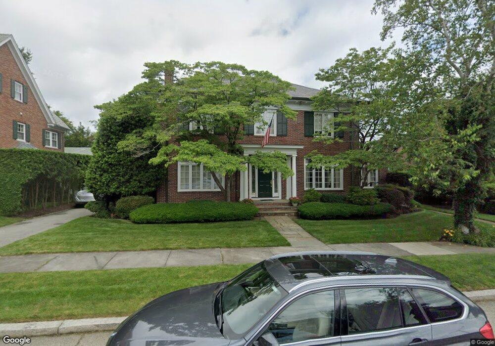
14 Wingate Rd Providence, RI 02906
Blackstone NeighborhoodEstimated Value: $2,115,661 - $2,354,000
4
Beds
4
Baths
3,940
Sq Ft
$558/Sq Ft
Est. Value
About This Home
This home is located at 14 Wingate Rd, Providence, RI 02906 and is currently estimated at $2,200,220, approximately $558 per square foot. 14 Wingate Rd is a home located in Providence County with nearby schools including Asa Messer Elementary School, Charles N. Fortes Elementary School, and Veazie Street Elementary School.
Ownership History
Date
Name
Owned For
Owner Type
Purchase Details
Closed on
Oct 1, 2001
Sold by
Creamer Mary J
Bought by
Gernt Wallace B and Gernt Leslie W
Current Estimated Value
Purchase Details
Closed on
Aug 23, 1999
Sold by
Jefferson Raymond L and Jefferson Lydia
Bought by
Taylor Russell and Taylor Beverly
Purchase Details
Closed on
Aug 16, 1994
Sold by
Mandell Jane F
Bought by
Creamer Glenn M and Creamer Mary
Create a Home Valuation Report for This Property
The Home Valuation Report is an in-depth analysis detailing your home's value as well as a comparison with similar homes in the area
Home Values in the Area
Average Home Value in this Area
Purchase History
| Date | Buyer | Sale Price | Title Company |
|---|---|---|---|
| Gernt Wallace B | $795,000 | -- | |
| Taylor Russell | $110,000 | -- | |
| Creamer Glenn M | $384,000 | -- |
Source: Public Records
Mortgage History
| Date | Status | Borrower | Loan Amount |
|---|---|---|---|
| Open | Creamer Glenn M | $188,000 | |
| Closed | Creamer Glenn M | $100,000 | |
| Closed | Creamer Glenn M | $260,000 |
Source: Public Records
Tax History Compared to Growth
Tax History
| Year | Tax Paid | Tax Assessment Tax Assessment Total Assessment is a certain percentage of the fair market value that is determined by local assessors to be the total taxable value of land and additions on the property. | Land | Improvement |
|---|---|---|---|---|
| 2025 | $13,763 | $1,638,400 | $819,000 | $819,400 |
| 2024 | $22,376 | $1,219,400 | $407,400 | $812,000 |
| 2023 | $22,376 | $1,219,400 | $407,400 | $812,000 |
| 2022 | $21,705 | $1,219,400 | $407,400 | $812,000 |
| 2021 | $21,102 | $859,200 | $311,700 | $547,500 |
| 2020 | $21,102 | $859,200 | $311,700 | $547,500 |
| 2019 | $21,102 | $859,200 | $311,700 | $547,500 |
| 2018 | $30,368 | $950,200 | $267,700 | $682,500 |
| 2017 | $30,368 | $950,200 | $267,700 | $682,500 |
| 2016 | $30,368 | $950,200 | $267,700 | $682,500 |
| 2015 | $31,309 | $945,900 | $283,400 | $662,500 |
| 2014 | $31,924 | $945,900 | $283,400 | $662,500 |
| 2013 | $31,924 | $945,900 | $283,400 | $662,500 |
Source: Public Records
Map
Nearby Homes
- 62 Harwich Rd
- 41 Wingate Rd
- 640 Elmgrove Ave
- 767 Elmgrove Ave
- 750 Elmgrove Ave
- 540 Blackstone Blvd
- 436 Blackstone Blvd
- 62 Overhill Rd
- 873 Hope St
- 32 Glendale Ave
- 132 11th St
- 202 Rochambeau Ave Unit 2
- 151 Chace Ave
- 296 Cole Ave
- 294 Cole Ave
- 172 Chace Ave
- 15 Taft Ave
- 141 Hillside Ave
- 136 Hillside Ave
- 142 Ridge St