
140 Deer Ridge Trail Smithville, OK 74957
Estimated payment $2,700/month
Highlights
- Corner Lot
- 1-Story Property
- Gas Log Fireplace
About This Home
For Sale- 3 bed/ 2 bath log cabin in Smithville, OK. Has a long term renter! Located close to Mt Fork River! Enjoy direct access to the Upper Mountain Fork River landing less than a minute away for kayaking, floating, or casting a line. Located about 13 miles from Broken Bow Lake and Beavers Bend State Park. About 3 hours from Oklahoma City and Dallas–Fort Worth. Schedule your showing today.
Home Details
Home Type
- Single Family
Est. Annual Taxes
- $1,125
Year Built
- Built in 2006
Lot Details
- 1.57 Acre Lot
- Corner Lot
Parking
- No Garage
Home Design
- Slab Foundation
- Frame Construction
- Composition Roof
Interior Spaces
- 1,216 Sq Ft Home
- 1-Story Property
- Gas Log Fireplace
Bedrooms and Bathrooms
- 3 Bedrooms
- 2 Full Bathrooms
Schools
- Smithville Elementary School
- Smithville Middle School
- Smithville High School
Utilities
- Heat Pump System
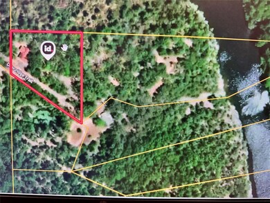
Map
Home Values in the Area
Average Home Value in this Area
Tax History
| Year | Tax Paid | Tax Assessment Tax Assessment Total Assessment is a certain percentage of the fair market value that is determined by local assessors to be the total taxable value of land and additions on the property. | Land | Improvement |
|---|---|---|---|---|
| 2025 | $1,125 | $14,519 | $248 | $14,271 |
| 2024 | $1,125 | $13,828 | $236 | $13,592 |
| 2023 | $1,093 | $13,169 | $236 | $12,933 |
| 2022 | $1,094 | $13,169 | $236 | $12,933 |
| 2021 | $1,097 | $13,169 | $236 | $12,933 |
| 2020 | $1,100 | $13,169 | $236 | $12,933 |
| 2019 | $1,107 | $13,169 | $236 | $12,933 |
| 2018 | $1,120 | $13,169 | $236 | $12,933 |
| 2017 | $1,079 | $13,105 | $236 | $12,869 |
| 2016 | $1,033 | $12,481 | $236 | $12,245 |
| 2015 | $1,039 | $12,420 | $236 | $12,184 |
| 2014 | $1,026 | $12,420 | $236 | $12,184 |
Property History
| Date | Event | Price | List to Sale | Price per Sq Ft |
|---|---|---|---|---|
| 12/03/2025 12/03/25 | For Sale | $495,000 | -- | $407 / Sq Ft |
Purchase History
| Date | Type | Sale Price | Title Company |
|---|---|---|---|
| Warranty Deed | -- | None Available | |
| Warranty Deed | $78,000 | None Available |
Mortgage History
| Date | Status | Loan Amount | Loan Type |
|---|---|---|---|
| Previous Owner | $208,000 | Commercial |
Source: MLSOK
MLS Number: 1204496
APN: 0226-00-000-001-0-000-00
Disclaimer: Certain information contained herein is derived from information provided by parties other than Homes.com. All information provided is deemed reliable, but is not guaranteed to be accurate and should be independently verified.
![]() IDX information is provided exclusively for personal, non-commercial use, and may not be used for any purpose other than to identify prospective properties consumers may be interested in purchasing.
IDX information is provided exclusively for personal, non-commercial use, and may not be used for any purpose other than to identify prospective properties consumers may be interested in purchasing.
Information is deemed reliable but not guaranteed.
This information is not verified for authenticity or accuracy, is not guaranteed and may not reflect all real estate activity in the market.
Copyright 2025 MLSOK, Inc. All rights reserved.
- 219 Deer Ridge Trail
- 387 River Bend Rd
- 24 Sunfish Creek Trail
- 1384 Loop Rd
- 1 Riverside Ln
- 871 Riverview Rd
- 380 Eagle Fork Rd
- 20 Eagle Fork Rd
- 000 Eagle Fork Rd
- 00000 Eagle Fork Rd
- 0000 Eagle Fork Rd
- Old State Hwy 4
- 6093 Buffalo Rd
- TBD Old Hwy 4
- 1000 E Beachton Rd
- 0 Tbd Riverside Trail
- TBD Loop Rd
- 0 Loop Rd Unit 24999608
- Rd
- Tract 2 Hidden Creek Rd
