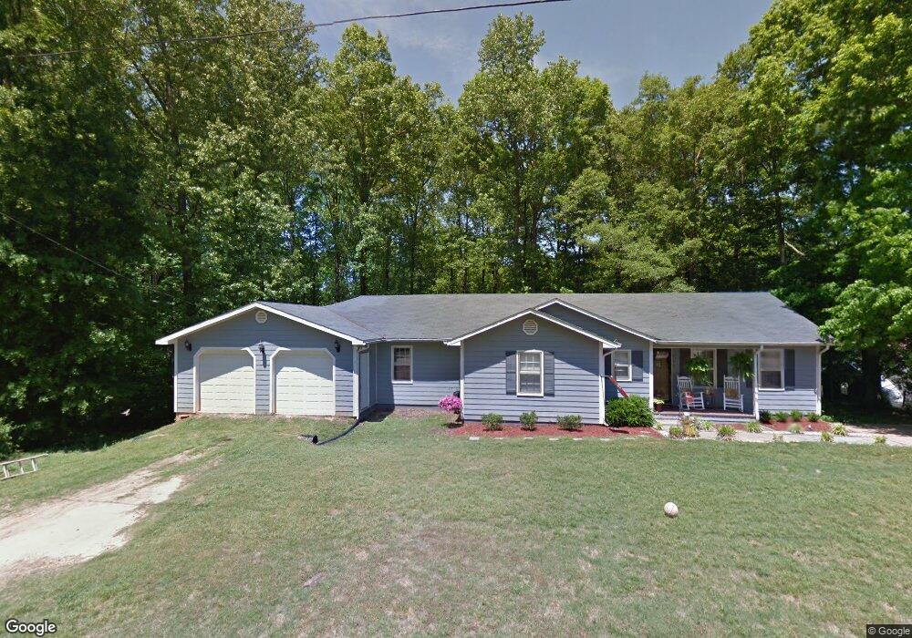
140 Forrest Dr Lavonia, GA 30553
Estimated Value: $279,000 - $394,000
4
Beds
3
Baths
2,280
Sq Ft
$140/Sq Ft
Est. Value
About This Home
This home is located at 140 Forrest Dr, Lavonia, GA 30553 and is currently estimated at $318,633, approximately $139 per square foot. 140 Forrest Dr is a home located in Franklin County with nearby schools including Franklin County High School.
Ownership History
Date
Name
Owned For
Owner Type
Purchase Details
Closed on
Oct 15, 2019
Sold by
Scott James
Bought by
Wigfall Leroy and Wigfall Sabrina
Current Estimated Value
Home Financials for this Owner
Home Financials are based on the most recent Mortgage that was taken out on this home.
Original Mortgage
$156,120
Outstanding Balance
$140,054
Interest Rate
4.75%
Mortgage Type
FHA
Estimated Equity
$178,579
Purchase Details
Closed on
Feb 20, 2002
Sold by
Scott James Anthony
Bought by
Scott James Anthony and Scott Heather
Purchase Details
Closed on
Dec 29, 1997
Bought by
Scott James Anthony
Create a Home Valuation Report for This Property
The Home Valuation Report is an in-depth analysis detailing your home's value as well as a comparison with similar homes in the area
Home Values in the Area
Average Home Value in this Area
Purchase History
| Date | Buyer | Sale Price | Title Company |
|---|---|---|---|
| Wigfall Leroy | $159,000 | -- | |
| Scott James Anthony | -- | -- | |
| Scott James Anthony | $54,500 | -- |
Source: Public Records
Mortgage History
| Date | Status | Borrower | Loan Amount |
|---|---|---|---|
| Open | Wigfall Leroy | $156,120 |
Source: Public Records
Tax History Compared to Growth
Tax History
| Year | Tax Paid | Tax Assessment Tax Assessment Total Assessment is a certain percentage of the fair market value that is determined by local assessors to be the total taxable value of land and additions on the property. | Land | Improvement |
|---|---|---|---|---|
| 2024 | $1,998 | $83,958 | $5,040 | $78,918 |
| 2023 | $1,981 | $76,784 | $5,040 | $71,744 |
| 2022 | $1,812 | $70,244 | $5,040 | $65,204 |
| 2021 | $1,679 | $61,020 | $4,320 | $56,700 |
| 2020 | $1,697 | $61,020 | $4,320 | $56,700 |
| 2019 | $1,348 | $52,192 | $4,320 | $47,872 |
| 2018 | $1,149 | $44,776 | $4,320 | $40,456 |
| 2017 | $1,195 | $44,776 | $4,320 | $40,456 |
| 2016 | $1,058 | $38,270 | $4,320 | $33,950 |
| 2015 | -- | $38,270 | $4,320 | $33,950 |
| 2014 | -- | $38,270 | $4,320 | $33,950 |
| 2013 | -- | $25,572 | $4,320 | $21,252 |
Source: Public Records
Map
Nearby Homes
- 4094 Lankford Rd
- 4025 Lankford Rd
- 266 Randall St
- 86 Luckie St
- 0 Highway 59 Unit 10615036
- 353 Bow Dr
- 5710 Vickery St
- 90 Old City Park Rd
- 5494 Vickery St
- 5474 Vickery St
- 0 Hwy 59 and Ross Place Unit 10499138
- 89 Huntington Dr
- 103 Ross Place
- 138 Victoria Ln
- 49 Wright St Unit 65
- 45 Wright St Unit 64
- 57 Wright St Unit 68
- 55 Wright St Unit 67
- 51 Wright St Unit 66
- 59 Wright St Unit 69
- 65 Hill St
- 0 Forrest Dr
- 176 Forrest Dr Unit 43900
- 176 Forrest Dr
- 161 Forrest Dr
- 121 Forrest Dr
- 191 Forrest Dr
- 0 Brown Dr Unit 8102812
- 0 Brown Dr
- 85 Forrest Dr
- 53 Hill St
- 47 Hill St
- 11383 Highway 17
- 30 Forrest Dr
- 11451 Highway 17
- 11285 Georgia 17
- 57 Brown Dr
- 309 Forrest Dr
- 14383 Georgia 17
- 11280 Highway 17