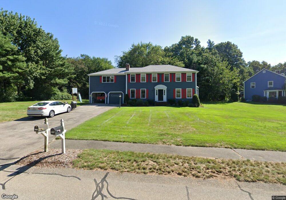
140 Laurie Ln Wrentham, MA 02093
Estimated Value: $897,740 - $1,037,000
4
Beds
3
Baths
2,859
Sq Ft
$340/Sq Ft
Est. Value
About This Home
This home is located at 140 Laurie Ln, Wrentham, MA 02093 and is currently estimated at $970,685, approximately $339 per square foot. 140 Laurie Ln is a home located in Norfolk County with nearby schools including Delaney Elementary School and Charles E Roderick.
Ownership History
Date
Name
Owned For
Owner Type
Purchase Details
Closed on
Jul 3, 1991
Sold by
Lorusso Carmine and Lorusso Anthony
Bought by
Uyrus David T and Uyrus Heidi A
Current Estimated Value
Home Financials for this Owner
Home Financials are based on the most recent Mortgage that was taken out on this home.
Original Mortgage
$113,500
Interest Rate
9.37%
Mortgage Type
Purchase Money Mortgage
Create a Home Valuation Report for This Property
The Home Valuation Report is an in-depth analysis detailing your home's value as well as a comparison with similar homes in the area
Home Values in the Area
Average Home Value in this Area
Purchase History
| Date | Buyer | Sale Price | Title Company |
|---|---|---|---|
| Uyrus David T | $225,000 | -- |
Source: Public Records
Mortgage History
| Date | Status | Borrower | Loan Amount |
|---|---|---|---|
| Closed | Uyrus David T | $107,100 | |
| Closed | Uyrus David T | $113,500 |
Source: Public Records
Tax History Compared to Growth
Tax History
| Year | Tax Paid | Tax Assessment Tax Assessment Total Assessment is a certain percentage of the fair market value that is determined by local assessors to be the total taxable value of land and additions on the property. | Land | Improvement |
|---|---|---|---|---|
| 2025 | $9,009 | $777,300 | $312,400 | $464,900 |
| 2024 | $8,682 | $723,500 | $312,400 | $411,100 |
| 2023 | $8,428 | $667,800 | $284,100 | $383,700 |
| 2022 | $7,590 | $555,200 | $218,700 | $336,500 |
| 2021 | $7,580 | $538,700 | $229,200 | $309,500 |
| 2020 | $7,236 | $507,800 | $206,700 | $301,100 |
| 2019 | $6,977 | $494,100 | $206,700 | $287,400 |
| 2018 | $7,042 | $494,500 | $206,900 | $287,600 |
| 2017 | $6,881 | $482,900 | $202,900 | $280,000 |
| 2016 | $6,734 | $471,600 | $197,000 | $274,600 |
| 2015 | $6,374 | $425,500 | $174,800 | $250,700 |
| 2014 | $6,271 | $409,600 | $168,200 | $241,400 |
Source: Public Records
Map
Nearby Homes
- 570 Franklin St
- 50 Reed Fulton Ave Unit Lot 61
- 45 Joshua Rd
- 131 Creek St Unit 7
- 10 Nature View Dr
- 15 Nature View Dr
- 246 Forest Grove Ave
- 11 Earle Stewart Ln
- Lot 3 - 14 Earle Stewart Ln
- Lot 1 - Blueberry 2 Car Plan at King Philip Estates
- Lot 8 - Blueberry 2 Car Plan at King Philip Estates
- Lot 5 - Hughes 2 car Plan at King Philip Estates
- Lot 6 - Blueberry 3 Car Plan at King Philip Estates
- Lot 2 - Camden 2 Car Plan at King Philip Estates
- Lot 7 - Cedar Plan at King Philip Estates
- Lot 4 - Hemingway 2 Car Plan at King Philip Estates
- Lot 3 - Blueberry 2 Car Plan at King Philip Estates
- 270 Dedham St
- 12 Waites Crossing Way
- 11 Elliot Mills Unit 11