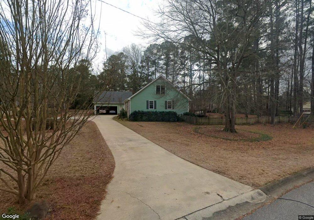
140 Lost Tree Trail Athens, GA 30605
Cedar Creek NeighborhoodEstimated Value: $386,207 - $428,000
3
Beds
2
Baths
2,642
Sq Ft
$157/Sq Ft
Est. Value
About This Home
This home is located at 140 Lost Tree Trail, Athens, GA 30605 and is currently estimated at $414,552, approximately $156 per square foot. 140 Lost Tree Trail is a home located in Clarke County with nearby schools including Hilsman Middle School, Cedar Shoals High School, and Athens Montessori School.
Ownership History
Date
Name
Owned For
Owner Type
Purchase Details
Closed on
Dec 7, 2012
Sold by
Parish Randall R
Bought by
Parish Randall R and Parish Susan D Pari
Current Estimated Value
Purchase Details
Closed on
Sep 29, 2006
Sold by
Not Provided
Bought by
Parish Randall R and Parish Susan D
Home Financials for this Owner
Home Financials are based on the most recent Mortgage that was taken out on this home.
Original Mortgage
$132,700
Interest Rate
6.36%
Mortgage Type
New Conventional
Create a Home Valuation Report for This Property
The Home Valuation Report is an in-depth analysis detailing your home's value as well as a comparison with similar homes in the area
Home Values in the Area
Average Home Value in this Area
Purchase History
| Date | Buyer | Sale Price | Title Company |
|---|---|---|---|
| Parish Randall R | -- | -- | |
| Parish Randall R | $165,900 | -- |
Source: Public Records
Mortgage History
| Date | Status | Borrower | Loan Amount |
|---|---|---|---|
| Previous Owner | Parish Randall R | $132,700 |
Source: Public Records
Tax History
| Year | Tax Paid | Tax Assessment Tax Assessment Total Assessment is a certain percentage of the fair market value that is determined by local assessors to be the total taxable value of land and additions on the property. | Land | Improvement |
|---|---|---|---|---|
| 2025 | $2,877 | $165,146 | $14,000 | $151,146 |
| 2024 | $2,877 | $157,122 | $14,000 | $143,122 |
| 2023 | $1,311 | $143,998 | $14,000 | $129,998 |
| 2022 | $2,802 | $127,804 | $14,000 | $113,804 |
| 2021 | $2,602 | $102,205 | $13,000 | $89,205 |
| 2020 | $2,288 | $89,654 | $13,000 | $76,654 |
| 2019 | $2,224 | $83,662 | $13,000 | $70,662 |
| 2018 | $2,127 | $76,702 | $13,000 | $63,702 |
| 2017 | $2,054 | $71,463 | $13,000 | $58,463 |
| 2016 | $2,028 | $69,727 | $13,000 | $56,727 |
| 2015 | $2,034 | $69,818 | $13,000 | $56,818 |
| 2014 | $2,060 | $70,472 | $13,000 | $57,472 |
Source: Public Records
Map
Nearby Homes
- 306 Cedar Springs Dr
- 160 Knob Lick Dr
- 250 Highland Park Dr
- 720 Whit Davis Rd
- 170 Dunwoody Dr
- 188 Dunwoody Dr
- 399 Mcduffie Dr
- 400 Sandstone Dr
- 132 Whisperwood Ln
- 135 Pettit Ln
- 260 Pettit Ln
- 149 Oak Meadow Dr
- 293 Carrington Dr
- 135 Mcduffie Dr
- 1305 Whit Davis Rd
- 127 McCrackin Ct
- 625 Forest Rd
- 440 Wood Ln
- 135 Longbranch Ct
- 1305 Cedar Shoals Dr Unit 500
- 180 Lost Tree Trail
- 521 Sandstone Dr
- 520 Sandstone Dr
- 145 Lost Tree Trail
- 515 Sandstone Dr
- 200 Lost Tree Trail
- 165 Lost Tree Trail
- 530 Sandstone Dr
- 210 Lost Tree Trail
- 510 Sandstone Dr
- 185 Lost Tree Trail
- 525 Sandstone Dr
- 505 Sandstone Dr
- 120 Knob Lick Dr
- 195 Lost Tree Trail
- 220 Lost Tree Trail
- 110 Knob Lick Dr
- 130 Knob Lick Dr
- 540 Sandstone Dr
- 535 Sandstone Dr
Your Personal Tour Guide
Ask me questions while you tour the home.