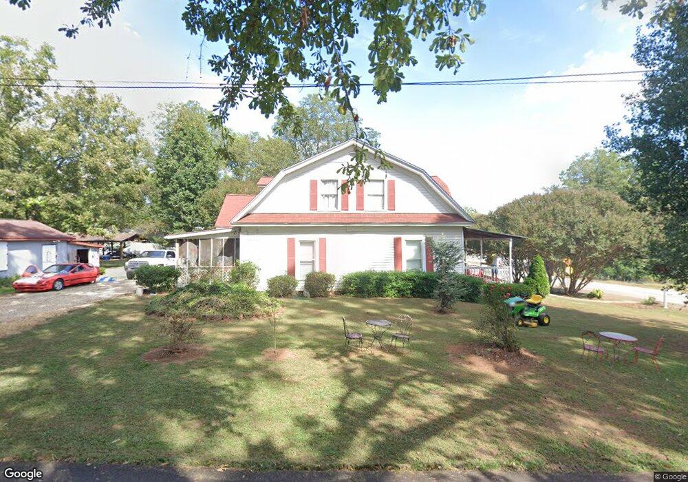
140 W Broad St Hoschton, GA 30548
Estimated Value: $363,302 - $551,000
3
Beds
2
Baths
2,674
Sq Ft
$158/Sq Ft
Est. Value
About This Home
This home is located at 140 W Broad St, Hoschton, GA 30548 and is currently estimated at $423,576, approximately $158 per square foot. 140 W Broad St is a home located in Jackson County with nearby schools including West Jackson Elementary School, West Jackson Middle School, and Jackson County High School.
Ownership History
Date
Name
Owned For
Owner Type
Purchase Details
Closed on
Nov 23, 2021
Sold by
Patrick John Stanley
Bought by
Patrick John Stanley and Patrick Cathy M
Current Estimated Value
Home Financials for this Owner
Home Financials are based on the most recent Mortgage that was taken out on this home.
Original Mortgage
$145,000
Outstanding Balance
$132,510
Interest Rate
3.14%
Mortgage Type
New Conventional
Estimated Equity
$291,066
Purchase Details
Closed on
Aug 12, 1997
Bought by
Patrick John Stanley
Create a Home Valuation Report for This Property
The Home Valuation Report is an in-depth analysis detailing your home's value as well as a comparison with similar homes in the area
Home Values in the Area
Average Home Value in this Area
Purchase History
| Date | Buyer | Sale Price | Title Company |
|---|---|---|---|
| Patrick John Stanley | -- | -- | |
| Patrick John Stanley | $90,000 | -- |
Source: Public Records
Mortgage History
| Date | Status | Borrower | Loan Amount |
|---|---|---|---|
| Open | Patrick John Stanley | $145,000 |
Source: Public Records
Tax History Compared to Growth
Tax History
| Year | Tax Paid | Tax Assessment Tax Assessment Total Assessment is a certain percentage of the fair market value that is determined by local assessors to be the total taxable value of land and additions on the property. | Land | Improvement |
|---|---|---|---|---|
| 2024 | $2,637 | $84,992 | $20,280 | $64,712 |
| 2023 | $2,637 | $76,856 | $20,280 | $56,576 |
| 2022 | $1,944 | $54,936 | $10,120 | $44,816 |
| 2021 | $1,717 | $54,936 | $10,120 | $44,816 |
| 2020 | $1,577 | $46,696 | $10,120 | $36,576 |
| 2019 | $1,605 | $46,696 | $10,120 | $36,576 |
| 2018 | $1,560 | $45,032 | $10,120 | $34,912 |
| 2017 | $1,457 | $41,894 | $8,113 | $33,781 |
| 2016 | $1,444 | $41,371 | $8,113 | $33,258 |
| 2015 | $1,450 | $41,371 | $8,113 | $33,258 |
| 2014 | $1,421 | $41,327 | $8,113 | $33,214 |
| 2013 | -- | $41,326 | $8,112 | $33,214 |
Source: Public Records
Map
Nearby Homes
- 176 Bell Ave
- 74 White St
- 289 Bell Ave
- 372 Meadow Vista Ln
- 329 Winterset Cir
- 92 Hawthorn Way
- 584 Amaranth Trail
- 8422 Pendergrass Rd
- 49 Creekside Commons Dr
- 45 Creekside Commons Dr
- 41 Creekside Commons Dr
- 37 Creekside Commons Dr
- 21 Creekside Commons Dr
- 15 Creekside Commons Dr
- 22 Huntley Trace Unit 230
- 60 Huntley Trace
- 1948 Nuthatch Dr
- 2018 Nuthatch Dr
- 2048 Nuthatch Dr
- 1978 Nuthatch Dr
- 1988 Nuthatch Dr
- 2088 Nuthatch Dr
- 2028 Nuthatch Dr
- 81 Pecan Ct
- 63 Pecan Ct
- 201 Clear Lake Pkwy
- 512 Crystal Lake Pkwy
- 556 Crystal Lake Pkwy
- 299 Bentwater Way
- 86 Pecan Ct
- 380 Red Wood Ln
- 459 Bentwater Way
- 444 Bentwater Way
- 487 Bentwater Way
- 473 Bentwater Way
- 392 Red Wood Ln