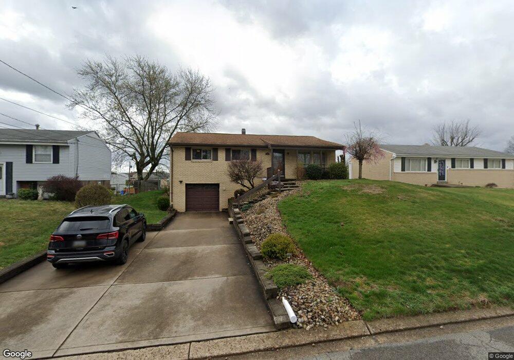
140 William Cir Mc Kees Rocks, PA 15136
Stowe Township NeighborhoodEstimated Value: $224,000 - $238,000
3
Beds
2
Baths
1,200
Sq Ft
$190/Sq Ft
Est. Value
About This Home
This home is located at 140 William Cir, Mc Kees Rocks, PA 15136 and is currently estimated at $228,049, approximately $190 per square foot. 140 William Cir is a home located in Allegheny County with nearby schools including Sto-Rox Upper Elementary School, Sto-Rox Primary Center, and Sto-Rox Junior/Senior High School.
Ownership History
Date
Name
Owned For
Owner Type
Purchase Details
Closed on
Aug 2, 2011
Bought by
Badstibner James C
Current Estimated Value
Purchase Details
Closed on
Aug 2, 2004
Sold by
Chappel Scott
Bought by
Crispin Todd
Home Financials for this Owner
Home Financials are based on the most recent Mortgage that was taken out on this home.
Original Mortgage
$89,000
Interest Rate
6.33%
Mortgage Type
New Conventional
Purchase Details
Closed on
Dec 28, 2000
Sold by
Bush Michael W and Bush Corina D
Bought by
Chappel Scott T and Garofolo Heather
Purchase Details
Closed on
May 28, 1999
Sold by
Parkes Timothy M and Parkes Jacquelyn
Bought by
Bush Michael W and Bush Corina D
Create a Home Valuation Report for This Property
The Home Valuation Report is an in-depth analysis detailing your home's value as well as a comparison with similar homes in the area
Home Values in the Area
Average Home Value in this Area
Purchase History
| Date | Buyer | Sale Price | Title Company |
|---|---|---|---|
| Badstibner James C | $120,500 | -- | |
| Crispin Todd | $112,000 | -- | |
| Chappel Scott T | $92,500 | Pennsylvania Land Titles | |
| Bush Michael W | $85,000 | -- |
Source: Public Records
Mortgage History
| Date | Status | Borrower | Loan Amount |
|---|---|---|---|
| Previous Owner | Crispin Todd | $89,000 |
Source: Public Records
Tax History Compared to Growth
Tax History
| Year | Tax Paid | Tax Assessment Tax Assessment Total Assessment is a certain percentage of the fair market value that is determined by local assessors to be the total taxable value of land and additions on the property. | Land | Improvement |
|---|---|---|---|---|
| 2025 | $3,331 | $77,100 | $20,200 | $56,900 |
| 2024 | $3,331 | $77,100 | $20,200 | $56,900 |
| 2023 | $3,202 | $77,100 | $20,200 | $56,900 |
| 2022 | $3,100 | $77,100 | $20,200 | $56,900 |
| 2021 | $365 | $77,100 | $20,200 | $56,900 |
| 2020 | $3,030 | $77,100 | $20,200 | $56,900 |
| 2019 | $3,030 | $77,100 | $20,200 | $56,900 |
| 2018 | $365 | $77,100 | $20,200 | $56,900 |
| 2017 | $2,961 | $77,100 | $20,200 | $56,900 |
| 2016 | $365 | $77,100 | $20,200 | $56,900 |
| 2015 | $365 | $77,100 | $20,200 | $56,900 |
| 2014 | $2,961 | $77,100 | $20,200 | $56,900 |
Source: Public Records
Map
Nearby Homes
- 179 William Cir
- 1550 Glenn Way
- 214 Barbara Dr
- 23 Castle View Dr
- 104 Thorncrest Dr
- 1490 Island Ave
- 86 Thorncrest Dr
- 1421 Fleming Ave
- 155 Roosevelt Ave
- 270 Wheeler Ave
- 8 Court Place
- 172 N Vireo Dr
- 1017 Mccoy Rd
- 124 Pleasant Ridge Rd
- 1408 Broadway Ave
- 108 Harrison Ave
- 1406 Broadway Ave
- 1212 Woodward Ave
- 932 Ridge Ave
- 205 S Ohio St
- 142 William Cir
- 144 William Cir
- 103 Homer Cir
- 105 Homer Cir
- 134 William Cir
- 101 Homer Cir
- 146 William Cir
- 141 William Cir
- 137 William Cir
- 130 William Cir
- 107 Homer Cir
- 135 William Cir
- 143 William Cir
- 148 William Cir
- 145 William Cir
- 133 Bellmawr Dr
- 109 Homer Cir
- 147 William Cir
- 150 William Cir
- 102 Homer Cir