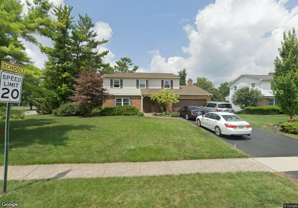
1400 Langston Dr Columbus, OH 43220
Estimated Value: $622,000 - $735,000
4
Beds
3
Baths
2,174
Sq Ft
$305/Sq Ft
Est. Value
About This Home
This home is located at 1400 Langston Dr, Columbus, OH 43220 and is currently estimated at $663,018, approximately $304 per square foot. 1400 Langston Dr is a home located in Franklin County with nearby schools including Greensview Elementary School, Hastings Middle School, and Upper Arlington High School.
Ownership History
Date
Name
Owned For
Owner Type
Purchase Details
Closed on
Sep 10, 2004
Sold by
Close Larry D and Close Jeri L
Bought by
Parker David T and Parker Janis L
Current Estimated Value
Home Financials for this Owner
Home Financials are based on the most recent Mortgage that was taken out on this home.
Original Mortgage
$236,000
Outstanding Balance
$118,477
Interest Rate
6.08%
Mortgage Type
Purchase Money Mortgage
Estimated Equity
$544,541
Purchase Details
Closed on
Apr 14, 2002
Sold by
Close Larry D and Close Jeri L
Bought by
Close Larry D and Close Jeri L
Purchase Details
Closed on
Aug 2, 1985
Bought by
Close Larry D
Create a Home Valuation Report for This Property
The Home Valuation Report is an in-depth analysis detailing your home's value as well as a comparison with similar homes in the area
Home Values in the Area
Average Home Value in this Area
Purchase History
| Date | Buyer | Sale Price | Title Company |
|---|---|---|---|
| Parker David T | $295,000 | -- | |
| Close Larry D | -- | Title First Agency Inc | |
| Close Larry D | $96,000 | -- |
Source: Public Records
Mortgage History
| Date | Status | Borrower | Loan Amount |
|---|---|---|---|
| Open | Parker David T | $236,000 |
Source: Public Records
Tax History Compared to Growth
Tax History
| Year | Tax Paid | Tax Assessment Tax Assessment Total Assessment is a certain percentage of the fair market value that is determined by local assessors to be the total taxable value of land and additions on the property. | Land | Improvement |
|---|---|---|---|---|
| 2024 | $11,702 | $202,130 | $88,410 | $113,720 |
| 2023 | $11,557 | $202,125 | $88,410 | $113,715 |
| 2022 | $9,578 | $137,070 | $55,690 | $81,380 |
| 2021 | $8,479 | $137,070 | $55,690 | $81,380 |
| 2020 | $9,529 | $137,070 | $55,690 | $81,380 |
| 2019 | $8,104 | $116,870 | $55,690 | $61,180 |
| 2018 | $7,821 | $116,870 | $55,690 | $61,180 |
| 2017 | $7,816 | $116,870 | $55,690 | $61,180 |
| 2016 | $7,590 | $114,800 | $43,470 | $71,330 |
| 2015 | $7,584 | $114,800 | $43,470 | $71,330 |
| 2014 | $7,592 | $114,800 | $43,470 | $71,330 |
| 2013 | $3,626 | $104,370 | $39,515 | $64,855 |
Source: Public Records
Map
Nearby Homes
- 1360 Langston Dr
- 1501 Bridgeton Dr
- 1512 Lafayette Dr Unit B
- 1514 Lafayette Dr Unit B
- 1424 Havencrest Ct
- 4543 Ducrest Dr
- 1610 Lafayette Dr Unit 1610
- 1594 Lafayette Dr Unit 1594
- 4094 Lyon Dr
- 4326 Kenny Rd
- 4714-4716 Arthur Ct
- 1033 Folkestone Rd
- 4818 -4820 Winterset Dr
- 4692 Charecote Ln Unit E
- 1075 Merrimar Cir N Unit B
- 1466 Weybridge Rd
- 4720 Merrifield Place Unit 67
- 1046 Merrimar Cir N Unit B
- 1046 Merrimar Cir N Unit I
- 4924 Reed Rd Unit B
- 4286 Greensview Dr
- 4278 Greensview Dr
- 4294 Greensview Dr
- 1384 Langston Dr
- 4290 Greensview Dr
- 1383 Darcann Dr
- 4260 Greensview Dr
- 1372 Langston Dr
- 1371 Darcann Dr
- 4247 Chadbourne Dr
- 4263 Greensview Dr
- 4270 Greensview Dr
- 4248 Greensview Dr
- 4262 Greensview Dr
- 4302 Greensview Dr
- 1359 Darcann Dr
- 1390 Darcann Dr
- 4310 Greensview Dr
- 4241 Chadbourne Dr
- 1441 Langston Dr