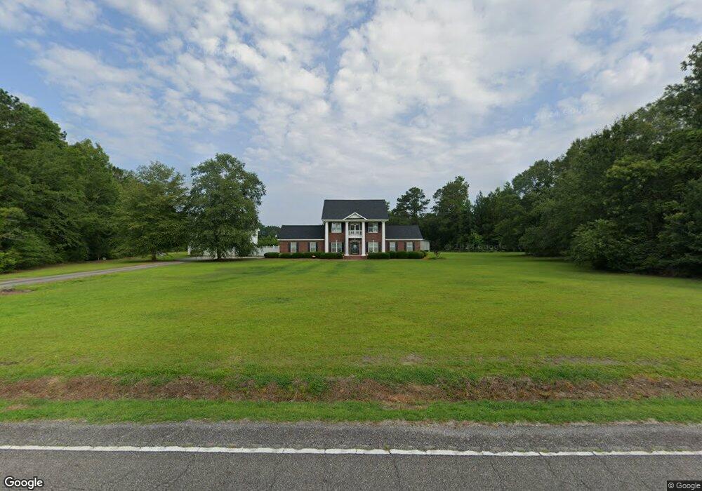
14007 Highway 19 Nichols, SC 29581
Estimated Value: $312,000 - $717,000
3
Beds
3
Baths
2,874
Sq Ft
$174/Sq Ft
Est. Value
About This Home
This home is located at 14007 Highway 19, Nichols, SC 29581 and is currently estimated at $499,288, approximately $173 per square foot. 14007 Highway 19 is a home located in Horry County with nearby schools including Green Sea Floyds Elementary School and Green Sea Floyds High School.
Ownership History
Date
Name
Owned For
Owner Type
Purchase Details
Closed on
Feb 6, 2003
Sold by
Collins Christopher Rogers
Bought by
Collins Christopher Rogers and Collins Trella R
Current Estimated Value
Purchase Details
Closed on
Apr 27, 2000
Sold by
Collins P C
Bought by
Collins Christopher Rogers
Create a Home Valuation Report for This Property
The Home Valuation Report is an in-depth analysis detailing your home's value as well as a comparison with similar homes in the area
Home Values in the Area
Average Home Value in this Area
Purchase History
| Date | Buyer | Sale Price | Title Company |
|---|---|---|---|
| Collins Christopher Rogers | -- | -- | |
| Collins Christopher Rogers | -- | -- |
Source: Public Records
Tax History Compared to Growth
Tax History
| Year | Tax Paid | Tax Assessment Tax Assessment Total Assessment is a certain percentage of the fair market value that is determined by local assessors to be the total taxable value of land and additions on the property. | Land | Improvement |
|---|---|---|---|---|
| 2024 | $1,112 | $17,153 | $2,827 | $14,326 |
| 2023 | $1,112 | $9,682 | $448 | $9,234 |
| 2021 | $1,005 | $27,992 | $1,175 | $26,817 |
| 2020 | $887 | $27,992 | $1,175 | $26,817 |
| 2019 | $887 | $27,992 | $1,175 | $26,817 |
| 2018 | $799 | $22,099 | $1,057 | $21,042 |
| 2017 | $784 | $21,445 | $403 | $21,042 |
| 2016 | -- | $21,445 | $403 | $21,042 |
| 2015 | $784 | $8,419 | $403 | $8,016 |
| 2014 | $723 | $8,419 | $403 | $8,016 |
Source: Public Records
Map
Nearby Homes
- TBD Pleasant View Church Rd
- 5671 Highway 917 Unit 19
- Tbd Hwy 19 Unit LotWP001
- 6800 Black Creek Rd
- Tract 2 Beth Dr
- 46.89 Ac Tbd Beth Ln
- TBD Black Creek Rd
- Tbd Shelley Rd
- TBD Long Branch Swamp Rd
- 7320 Maple Wild Rd
- Tbd Shelley Road Coventry Rd
- Tbd Bellaire Dr Unit 4
- 36.4 Acres-TBD State Road S-26-266
- Multiple Lots State Road S-26-266
- LOT 5 State Road S-26-266
- 41.98 Ac Tbd Black Creek Rd
- LOT 3 State Road S-26-266
- Lot B3 Black Creek Rd
- TBD Bellaire Dr Unit Lot 6
- TBD Bellaire Dr Unit Lot 7
- 14011 Highway 19
- 13911 W Highway 19
- 14262 Highway 19
- TBD Pleasant View Church Rd Unit Lot C1-3
- 6080 Pleasant View Church Rd
- Track A Pleasant View Church Rd
- 14296 Highway 19
- 6300 Black Creek Rd
- 5979 Pleasant View Church Rd
- 1125 Liner Rd
- 6400 Black Creek Rd Unit 2 Tracts totaling 93
- 5476 Highway 917
- 5676 Highway 917
- 6608 State Road S-26-266
- 14326 Highway 19 Unit 14304, 14350
- 14326 Highway 19
- 00 Black Creek Rd
- 160 Worley Ln
- 6490 State Road S-26-266
- 6410 Black Creek Rd