M
Seller's Agent in 2026
Mark Zullner
Badger Realty Team - Greenfield
(262) 422-1611
4 in this area
20 Total Sales
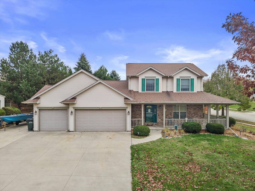
Step inside and fall in love with this beautifully updated spacious 3 bedroom home. It boasts a large and bright living room, a spacious kitchen. Enjoy the first floor family room with a fireplace and walk out to the patio in the backyard. The larger corner lot with a secluded backyard. This move in ready home checks all of the boxes!
Last Agent to Sell the Property
Badger Realty Team - Greenfield License #94899-94 Listed on: 11/13/2025
| Date | Type | Sale Price | Title Company |
|---|---|---|---|
| Warranty Deed | $406,000 | Prism Title Midwest Llc | |
| Warranty Deed | $273,000 | None Available | |
| Warranty Deed | $215,000 | Lakefront Title Llc |
| Date | Status | Loan Amount | Loan Type |
|---|---|---|---|
| Open | $304,500 | No Value Available | |
| Previous Owner | $268,055 | FHA | |
| Previous Owner | $204,250 | New Conventional |
| Date | Event | Price | List to Sale | Price per Sq Ft |
|---|---|---|---|---|
| 01/06/2026 01/06/26 | Sold | $406,000 | +1.8% | $189 / Sq Ft |
| 11/15/2025 11/15/25 | Pending | -- | -- | -- |
| 11/13/2025 11/13/25 | For Sale | $399,000 | -- | $186 / Sq Ft |
| Year | Tax Paid | Tax Assessment Tax Assessment Total Assessment is a certain percentage of the fair market value that is determined by local assessors to be the total taxable value of land and additions on the property. | Land | Improvement |
|---|---|---|---|---|
| 2025 | $5,257 | $258,200 | $72,900 | $185,300 |
| 2024 | $4,438 | $326,800 | $55,900 | $270,900 |
| 2023 | $3,947 | $258,200 | $72,900 | $185,300 |
| 2022 | $4,725 | $258,200 | $72,900 | $185,300 |
| 2021 | $4,682 | $258,200 | $72,900 | $185,300 |
| 2020 | $4,577 | $258,200 | $72,900 | $185,300 |
| 2019 | $4,430 | $258,200 | $72,900 | $185,300 |
| 2018 | $4,299 | $258,200 | $72,900 | $185,300 |
| 2017 | $4,305 | $231,800 | $72,900 | $158,900 |
| 2016 | $4,334 | $231,800 | $72,900 | $158,900 |
| 2015 | $4,553 | $231,800 | $72,900 | $158,900 |
| 2014 | $4,553 | $239,200 | $72,900 | $166,300 |
| 2013 | $4,921 | $239,200 | $72,900 | $166,300 |
M
Seller's Agent in 2026
Mark Zullner
Badger Realty Team - Greenfield
(262) 422-1611
4 in this area
20 Total Sales
J
Buyer's Agent in 2026
Jessica Stacy
Real Broker Milwaukee
(847) 772-2486
1 in this area
83 Total Sales
Source: Metro MLS
MLS Number: 1942789
APN: 1119-121-0147
Disclaimer: Certain information contained herein is derived from information provided by parties other than Homes.com. All information provided is deemed reliable, but is not guaranteed to be accurate and should be independently verified.
![]() IDX information is provided exclusively for personal, non-commercial use, and may not be used for any purpose other than to identify prospective properties consumers may be interested in purchasing.
IDX information is provided exclusively for personal, non-commercial use, and may not be used for any purpose other than to identify prospective properties consumers may be interested in purchasing.
IDX listing data provided by Multiple Listing Service, Inc. Information is supplied by seller and other third parties and has not been verified.
Copyright 2026 – Multiple Listing Service, Inc. – All Rights Reserved.
Ask me questions while you tour the home.
