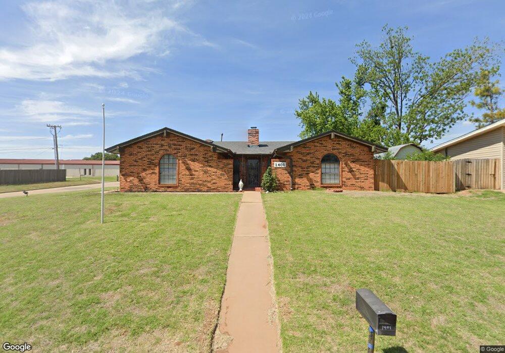
1401 Saber Ln Weatherford, OK 73096
Estimated Value: $197,513 - $229,000
2
Beds
2
Baths
1,463
Sq Ft
$143/Sq Ft
Est. Value
About This Home
This home is located at 1401 Saber Ln, Weatherford, OK 73096 and is currently estimated at $209,878, approximately $143 per square foot. 1401 Saber Ln is a home located in Custer County with nearby schools including Burcham Elementary School, Lt. General Thomas P. Stafford Elementary School, and Weatherford West Elementary School.
Ownership History
Date
Name
Owned For
Owner Type
Purchase Details
Closed on
Aug 13, 2013
Sold by
Vineyard Dale
Bought by
Cdv Series Llc "Saber"
Current Estimated Value
Purchase Details
Closed on
Nov 5, 2004
Sold by
Secretary Of Housing
Bought by
Dale Vineyard
Purchase Details
Closed on
Apr 9, 2004
Sold by
Linda C Henley Etvir
Bought by
Secretary Of Housing
Purchase Details
Closed on
Jul 9, 1999
Sold by
Alan D Palesano
Bought by
Linda C Henley Etvir
Purchase Details
Closed on
Apr 5, 1997
Sold by
Jack Naylor
Bought by
Alan D Palesano
Create a Home Valuation Report for This Property
The Home Valuation Report is an in-depth analysis detailing your home's value as well as a comparison with similar homes in the area
Home Values in the Area
Average Home Value in this Area
Purchase History
| Date | Buyer | Sale Price | Title Company |
|---|---|---|---|
| Cdv Series Llc "Saber" | -- | -- | |
| Dale Vineyard | -- | -- | |
| Secretary Of Housing | -- | -- | |
| Linda C Henley Etvir | $85,500 | -- | |
| Alan D Palesano | $77,500 | -- |
Source: Public Records
Tax History Compared to Growth
Tax History
| Year | Tax Paid | Tax Assessment Tax Assessment Total Assessment is a certain percentage of the fair market value that is determined by local assessors to be the total taxable value of land and additions on the property. | Land | Improvement |
|---|---|---|---|---|
| 2025 | $1,868 | $19,892 | $1,934 | $17,958 |
| 2024 | $1,868 | $18,944 | $1,934 | $17,010 |
| 2023 | $1,868 | $19,090 | $1,451 | $17,639 |
| 2022 | $1,770 | $18,398 | $1,417 | $16,981 |
| 2021 | $1,699 | $17,522 | $1,374 | $16,148 |
| 2020 | $1,682 | $16,688 | $1,333 | $15,355 |
| 2019 | $1,618 | $15,894 | $1,280 | $14,614 |
| 2018 | $1,401 | $15,137 | $1,251 | $13,886 |
| 2017 | $1,358 | $14,416 | $1,306 | $13,110 |
| 2016 | $1,306 | $13,730 | $1,222 | $12,508 |
| 2015 | $1,262 | $13,075 | $1,259 | $11,816 |
| 2014 | $1,199 | $12,453 | $1,225 | $11,228 |
Source: Public Records
Map
Nearby Homes
- 0 N Washington Ave
- 1312 Linwood St
- 1535 Mockingbird Ln
- 1316 N Lark St
- 1300 Crimson Dr
- 1016 N Washington Ave
- 1804 Kristie Ln
- 10009 Lark St
- 1509 Steiner Rd
- 1010 Stonegate Dr
- 1400 Rolling Hills St
- 1025 Gartrell Place
- 24130 E 1016 Rd
- 708 Cornerstone Ave
- 24126 E 1016 Rd
- 0 Debra Dr
- 24122 E 1016 Rd
- 1414 Chisholm Trail
- 1805 E Serenade St
- 1230 N Indiana St
- 1405 Saber Ln
- 1325 Saber Ln
- 1325 N Adams St
- 1324 N Terrace Dr
- 1409 Saber Ln
- 1320 N Terrace Dr
- 1321 Saber Ln
- 1413 Saber Ln
- 1321 N Adams St
- 23804 E 1082 Rd
- 23810 E 1082 Rd
- 23820 E 1082 Rd
- 23822 E 1082 Rd
- 1324 N Adams St
- 1325 N Terrace Dr
- 1316 N Terrace Dr
- 1317 Saber Ln
- 1329 N Terrace Dr
- 1317 N Adams St
- 1417 Saber Ln