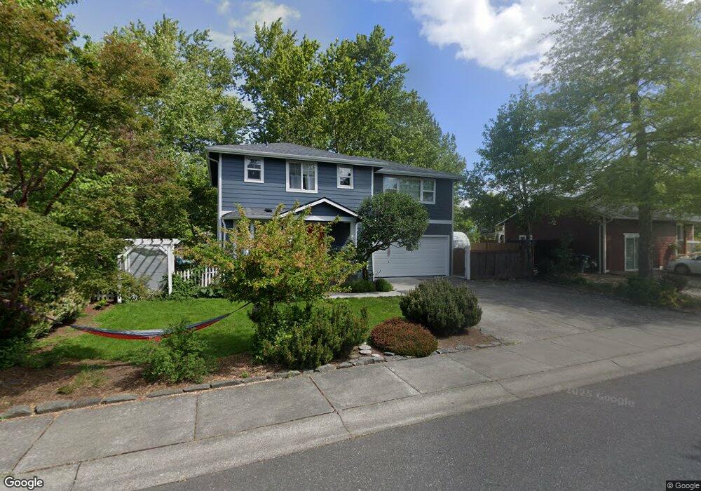
1403 Cranberry Ct Bellingham, WA 98226
King Mountain NeighborhoodEstimated Value: $581,696 - $602,000
3
Beds
3
Baths
1,488
Sq Ft
$399/Sq Ft
Est. Value
About This Home
This home is located at 1403 Cranberry Ct, Bellingham, WA 98226 and is currently estimated at $593,174, approximately $398 per square foot. 1403 Cranberry Ct is a home located in Whatcom County with nearby schools including Cordata Elementary School, Shuksan Middle School, and Squalicum High School.
Ownership History
Date
Name
Owned For
Owner Type
Purchase Details
Closed on
Mar 25, 2010
Sold by
Nelson Stanley J and Nelson Diane I
Bought by
Paterson Robert N and Lawrence Molly L
Current Estimated Value
Home Financials for this Owner
Home Financials are based on the most recent Mortgage that was taken out on this home.
Original Mortgage
$199,200
Outstanding Balance
$131,761
Interest Rate
4.94%
Mortgage Type
New Conventional
Estimated Equity
$461,413
Purchase Details
Closed on
Mar 20, 2007
Sold by
Sebastiani Michael and Sebastiani Laura
Bought by
Nelson Stanley and Nelson Diane
Purchase Details
Closed on
Jan 28, 2002
Sold by
D B Johnson Construction Inc
Bought by
Sebastiani Michael and Sebastiani Laura
Home Financials for this Owner
Home Financials are based on the most recent Mortgage that was taken out on this home.
Original Mortgage
$140,022
Interest Rate
7.17%
Mortgage Type
FHA
Create a Home Valuation Report for This Property
The Home Valuation Report is an in-depth analysis detailing your home's value as well as a comparison with similar homes in the area
Home Values in the Area
Average Home Value in this Area
Purchase History
| Date | Buyer | Sale Price | Title Company |
|---|---|---|---|
| Paterson Robert N | $249,280 | Whatcom Land Title | |
| Nelson Stanley | $273,830 | First American Title Insuran | |
| Sebastiani Michael | $142,000 | Whatcom Land Title |
Source: Public Records
Mortgage History
| Date | Status | Borrower | Loan Amount |
|---|---|---|---|
| Open | Paterson Robert N | $199,200 | |
| Previous Owner | Sebastiani Michael | $140,022 | |
| Closed | Sebastiani Michael | $1,835 |
Source: Public Records
Tax History Compared to Growth
Tax History
| Year | Tax Paid | Tax Assessment Tax Assessment Total Assessment is a certain percentage of the fair market value that is determined by local assessors to be the total taxable value of land and additions on the property. | Land | Improvement |
|---|---|---|---|---|
| 2024 | $4,177 | $514,008 | $211,408 | $302,600 |
| 2023 | $4,177 | $536,610 | $220,704 | $315,906 |
| 2022 | $3,613 | $470,711 | $193,600 | $277,111 |
| 2021 | $3,214 | $389,017 | $160,000 | $229,017 |
| 2020 | $3,107 | $326,563 | $105,145 | $221,418 |
| 2019 | $2,779 | $305,105 | $98,314 | $206,791 |
| 2018 | $2,876 | $273,658 | $88,189 | $185,469 |
| 2017 | $2,501 | $242,135 | $78,030 | $164,105 |
| 2016 | $2,289 | $220,048 | $71,010 | $149,038 |
| 2015 | $2,425 | $209,644 | $67,500 | $142,144 |
| 2014 | -- | $214,934 | $64,500 | $150,434 |
| 2013 | -- | $205,736 | $62,500 | $143,236 |
Source: Public Records
Map
Nearby Homes
- 1414 Fruitland Dr
- 1629 Jills Ct Unit 6
- 1629 Jills Ct Unit 7
- 1629 Jills Ct Unit 4
- 1629 Jills Ct Unit 3
- 1629 Jills Ct Unit 8
- 1629 Jills Ct Unit 1
- 4053 Hammer Dr
- 1631 Jills Ct Unit 4
- 1631 Jills Ct Unit 14
- 1631 Jills Ct Unit 13
- 1631 Jills Ct Unit 11
- 1631 Jills Ct Unit 3
- 1631 Jills Ct Unit 17
- 1631 Jills Ct Unit 15
- 1631 Jills Ct Unit 8
- 1631 Jills Ct Unit 12
- 1631 Jills Ct Unit 9
- 1631 Jills Ct Unit 5
- 1631 Jills Ct Unit 16
- 1321 Cranberry Ct
- 1407 Cranberry Ct
- 1317 Cranberry Ct
- 1404 Cranberry Ct
- 1324 Cranberry Ct
- 1408 Cranberry Ct
- 1320 Cranberry Ct
- 1315 Cranberry Ct
- 1312 Cranberry Ct
- 1503 Fruitland Dr
- 1445 Fruitland Dr
- 1309 Cranberry Ct
- 1460 Fruitland Dr
- 1507 Fruitland Dr
- 1464 Fruitland Dr
- 1308 Cranberry Ct
- 1456 Fruitland Dr
- 1468 Fruitland Dr
- 1452 Fruitland Dr
- 1472 Fruitland Dr