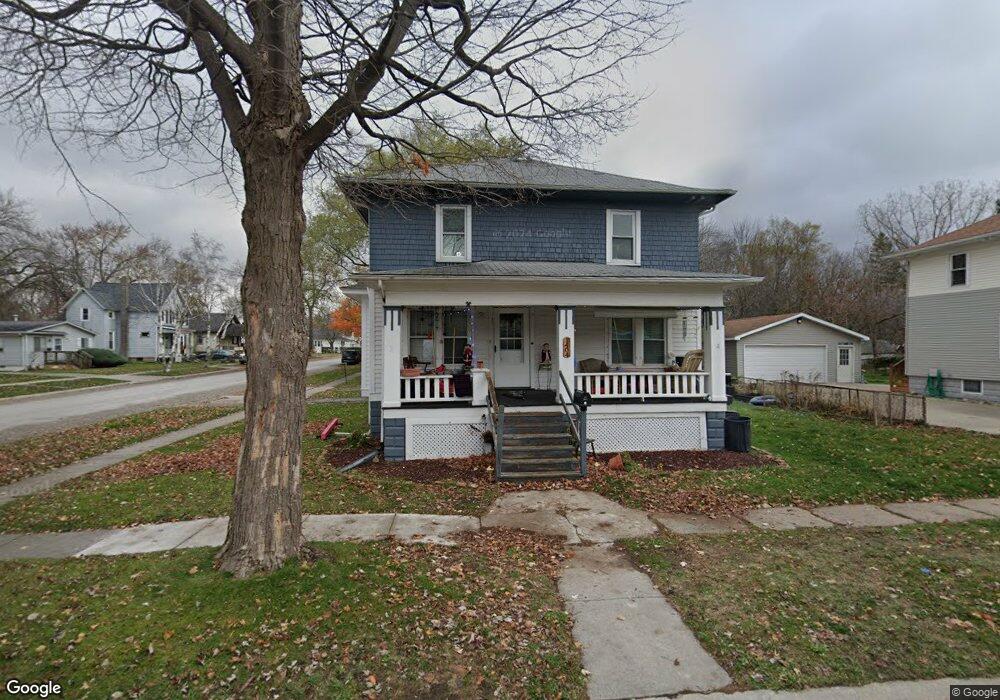
1404 12th St Port Huron, MI 48060
Estimated Value: $129,000 - $154,000
4
Beds
1
Bath
1,464
Sq Ft
$96/Sq Ft
Est. Value
About This Home
This home is located at 1404 12th St, Port Huron, MI 48060 and is currently estimated at $140,290, approximately $95 per square foot. 1404 12th St is a home located in St. Clair County with nearby schools including Woodrow Wilson Elementary School, Central Middle School, and Port Huron High School.
Ownership History
Date
Name
Owned For
Owner Type
Purchase Details
Closed on
Jun 14, 2013
Sold by
Hyslop Allen C and Hyslop Ma Teresa D
Bought by
Goel Arie and Goel Chana
Current Estimated Value
Purchase Details
Closed on
Dec 29, 2008
Sold by
Jt Bauer Holdings Llc
Bought by
Hyslop Allen C
Purchase Details
Closed on
Oct 25, 2007
Sold by
Oliver Vanessa K and Harvey Princeton L
Bought by
Wm Specialty Mortgage Llc
Create a Home Valuation Report for This Property
The Home Valuation Report is an in-depth analysis detailing your home's value as well as a comparison with similar homes in the area
Home Values in the Area
Average Home Value in this Area
Purchase History
| Date | Buyer | Sale Price | Title Company |
|---|---|---|---|
| Goel Arie | $21,250 | Liberty Title | |
| Hyslop Allen C | $19,900 | Lawyers Title | |
| Wm Specialty Mortgage Llc | $119,758 | None Available |
Source: Public Records
Tax History Compared to Growth
Tax History
| Year | Tax Paid | Tax Assessment Tax Assessment Total Assessment is a certain percentage of the fair market value that is determined by local assessors to be the total taxable value of land and additions on the property. | Land | Improvement |
|---|---|---|---|---|
| 2025 | $1,856 | $58,300 | $0 | $0 |
| 2024 | $1,602 | $55,200 | $0 | $0 |
| 2023 | $1,518 | $48,700 | $0 | $0 |
| 2022 | $1,495 | $40,200 | $0 | $0 |
| 2021 | $1,428 | $35,300 | $0 | $0 |
| 2020 | $1,433 | $30,900 | $30,900 | $0 |
| 2019 | $1,408 | $22,700 | $0 | $0 |
| 2018 | $1,376 | $22,700 | $0 | $0 |
| 2017 | $1,264 | $21,700 | $0 | $0 |
| 2016 | $1,124 | $21,700 | $0 | $0 |
| 2015 | $1,099 | $21,200 | $21,200 | $0 |
| 2014 | $1,099 | $20,400 | $20,400 | $0 |
| 2013 | -- | $20,500 | $0 | $0 |
Source: Public Records
Map
Nearby Homes
- 1130 Chestnut St
- 1403 12th St
- 1414 12th St
- 1133 Chestnut St
- 1129 Chestnut St
- 1413 12th St
- 1203 Chestnut St
- 1220 Chestnut St
- 1209 Chestnut St
- 1123 Chestnut St
- 1418 12th St Unit Bldg-Unit
- 1224 Chestnut St
- 1417 12th St
- 1326 12th St
- 1120 Chestnut St
- 1117 Chestnut St
- 1114 Chestnut St
- 1325 12th St
- 1322 12th St
- 1125 White St