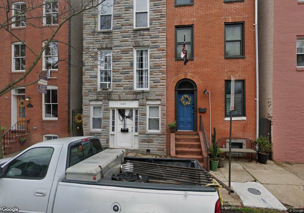
1404 Battery Ave Baltimore, MD 21230
Riverside NeighborhoodEstimated Value: $427,000
--
Bed
2
Baths
2,592
Sq Ft
$165/Sq Ft
Est. Value
About This Home
This home is located at 1404 Battery Ave, Baltimore, MD 21230 and is currently estimated at $427,000, approximately $164 per square foot. 1404 Battery Ave is a home located in Baltimore City with nearby schools including Thomas Johnson Elementary School, Booker T. Washington Middle School, and Paul Laurence Dunbar High School.
Ownership History
Date
Name
Owned For
Owner Type
Purchase Details
Closed on
Jul 19, 2013
Sold by
Stroup Janet L
Bought by
1500 Clarkston Street Llc
Current Estimated Value
Home Financials for this Owner
Home Financials are based on the most recent Mortgage that was taken out on this home.
Original Mortgage
$1,330,000
Outstanding Balance
$990,780
Interest Rate
4.51%
Mortgage Type
Purchase Money Mortgage
Estimated Equity
-$563,780
Purchase Details
Closed on
Mar 30, 1999
Sold by
Williamson Alfred L
Bought by
Strohecker Stephen H and Strokecker Diana L
Create a Home Valuation Report for This Property
The Home Valuation Report is an in-depth analysis detailing your home's value as well as a comparison with similar homes in the area
Home Values in the Area
Average Home Value in this Area
Purchase History
| Date | Buyer | Sale Price | Title Company |
|---|---|---|---|
| 1500 Clarkston Street Llc | -- | Continental Title Group | |
| Strohecker Stephen H | $99,000 | -- |
Source: Public Records
Mortgage History
| Date | Status | Borrower | Loan Amount |
|---|---|---|---|
| Open | 1500 Clarkston Street Llc | $1,330,000 |
Source: Public Records
Tax History Compared to Growth
Tax History
| Year | Tax Paid | Tax Assessment Tax Assessment Total Assessment is a certain percentage of the fair market value that is determined by local assessors to be the total taxable value of land and additions on the property. | Land | Improvement |
|---|---|---|---|---|
| 2025 | $7,283 | $317,633 | -- | -- |
| 2024 | $7,283 | $310,067 | $0 | $0 |
| 2023 | $7,105 | $302,500 | $110,000 | $192,500 |
| 2022 | $7,086 | $300,233 | $0 | $0 |
| 2021 | $7,032 | $297,967 | $0 | $0 |
| 2020 | $6,979 | $295,700 | $110,000 | $185,700 |
| 2019 | $6,945 | $295,667 | $0 | $0 |
| 2018 | $6,977 | $295,633 | $0 | $0 |
| 2017 | $6,976 | $295,600 | $0 | $0 |
| 2016 | $5,917 | $276,200 | $0 | $0 |
| 2015 | $5,917 | $256,800 | $0 | $0 |
| 2014 | $5,917 | $237,400 | $0 | $0 |
Source: Public Records
Map
Nearby Homes
- 1293 William St
- 1243 Battery Ave
- 1447 William St
- 1225 Wall St
- 200 E Fort Ave
- 104 Birckhead St
- 1221 William St
- 1230 Wall St
- 143 E West St
- 416 E Clement St
- 129 E West St
- 421 Folsom St
- 109 E West St
- 410 E Fort Ave
- 1211 Light St Unit T8
- 1211 Light St Unit 202
- 1134 Battery Ave
- 302 E West St
- 46 E Fort Ave
- 447 E Gittings St
- 1406 Battery Ave
- 1402 Battery Ave
- 1408 Battery Ave
- 1400 Battery Ave
- 1400 Battery Ave Unit 2
- 1410 Battery Ave
- 1412 Battery Ave
- 1414 Battery Ave
- 1416 Battery Ave
- 1407 William St
- 1405 William St
- 1409 William St
- 1418 Battery Ave
- 1411 William St
- 1401 William St
- 1413 William St
- 1403 William St
- 1415 William St
- 1420 Battery Ave
- 1417 William St