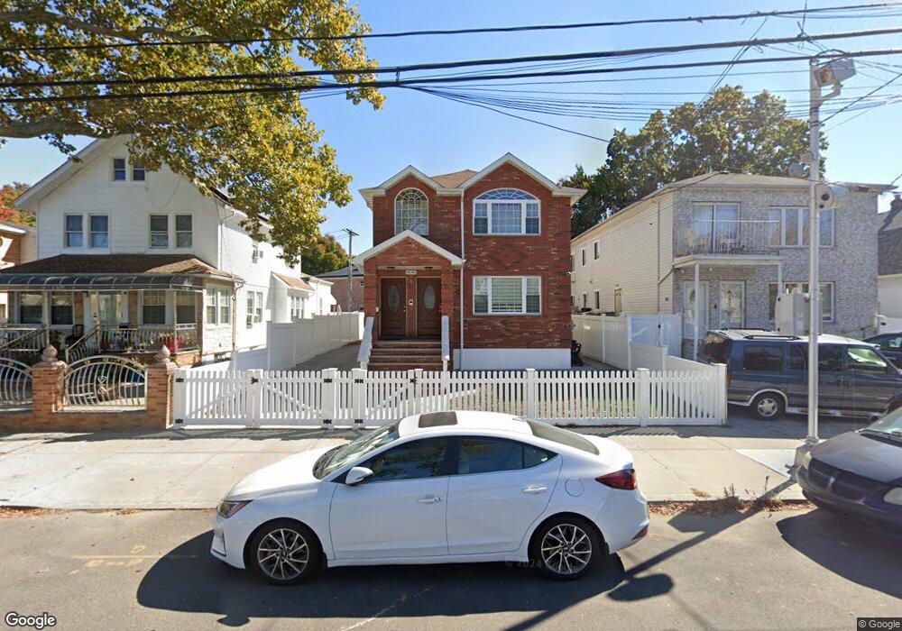
14043 243rd St Rosedale, NY 11422
Rosedale NeighborhoodEstimated Value: $1,051,482 - $1,169,000
--
Bed
3
Baths
2,382
Sq Ft
$458/Sq Ft
Est. Value
About This Home
This home is located at 14043 243rd St, Rosedale, NY 11422 and is currently estimated at $1,090,121, approximately $457 per square foot. 14043 243rd St is a home located in Queens County with nearby schools including P.S. / M.S. 138 Sunrise, Collaborative Arts Middle School, and Success Academy Charter School - Rosedale.
Ownership History
Date
Name
Owned For
Owner Type
Purchase Details
Closed on
Dec 20, 2017
Sold by
Executive Ent Group Llc
Bought by
Lall Brian M and Lall Ornella C
Current Estimated Value
Home Financials for this Owner
Home Financials are based on the most recent Mortgage that was taken out on this home.
Original Mortgage
$714,000
Outstanding Balance
$600,503
Interest Rate
3.9%
Mortgage Type
Unknown
Estimated Equity
$489,618
Purchase Details
Closed on
Apr 26, 2017
Sold by
Ryan Steven Ames
Bought by
Executive Ent Group Llc
Create a Home Valuation Report for This Property
The Home Valuation Report is an in-depth analysis detailing your home's value as well as a comparison with similar homes in the area
Home Values in the Area
Average Home Value in this Area
Purchase History
| Date | Buyer | Sale Price | Title Company |
|---|---|---|---|
| Lall Brian M | $869,000 | -- | |
| Executive Ent Group Llc | $325,000 | -- |
Source: Public Records
Mortgage History
| Date | Status | Borrower | Loan Amount |
|---|---|---|---|
| Open | Lall Brian M | $714,000 |
Source: Public Records
Tax History Compared to Growth
Tax History
| Year | Tax Paid | Tax Assessment Tax Assessment Total Assessment is a certain percentage of the fair market value that is determined by local assessors to be the total taxable value of land and additions on the property. | Land | Improvement |
|---|---|---|---|---|
| 2025 | $8,105 | $41,764 | $12,492 | $29,272 |
| 2024 | $8,105 | $40,352 | $14,463 | $25,889 |
| 2023 | $7,674 | $38,208 | $13,221 | $24,987 |
| 2022 | $7,196 | $51,600 | $18,000 | $33,600 |
| 2021 | $7,513 | $51,780 | $18,000 | $33,780 |
| 2020 | $7,367 | $52,800 | $18,000 | $34,800 |
| 2019 | $7,034 | $50,700 | $18,000 | $32,700 |
| 2017 | $3,743 | $18,360 | $4,754 | $13,606 |
| 2016 | $3,613 | $18,360 | $4,754 | $13,606 |
| 2015 | $2,089 | $17,325 | $6,462 | $10,863 |
| 2014 | $2,089 | $16,345 | $7,323 | $9,022 |
Source: Public Records
Map
Nearby Homes
- 241-33 143rd Ave
- 140-36 247th St
- 241-06 141st Ave
- 248-18 Memphis Ave
- 14027 247th St
- 24111 Weller Ave
- 240-20 142nd Ave
- 14224 250th St
- 141-40 250th St
- 24005 Weller Ave
- 139-21 246th St
- 243-38 144
- 251-20 Memphis Ave
- 13917 250th St
- 13834 247th St
- 249-21 145th Ave
- 139-16 Caney Ln
- 14432 Weller Ln
- 13826 Brookville Blvd
- 24026 Mayda Rd
- 14043 243rd St
- 14043 243rd St
- 14047 243rd St
- 14039 243rd St
- 141-05 243rd St
- 14101 243rd St
- 14035 243rd St
- 24316 Memphis Ave
- 24316 Memphis Ave
- 14105 243rd St
- 24602 Memphis Ave
- 140-35 243rd St
- 14044 243rd St
- 14109 243rd St
- 14038 243rd St
- 141-09 243rd St Unit 2
- 24136 141st Ave
- 24608 Memphis Ave
- 140-34 243rd St
- 14034 243rd St