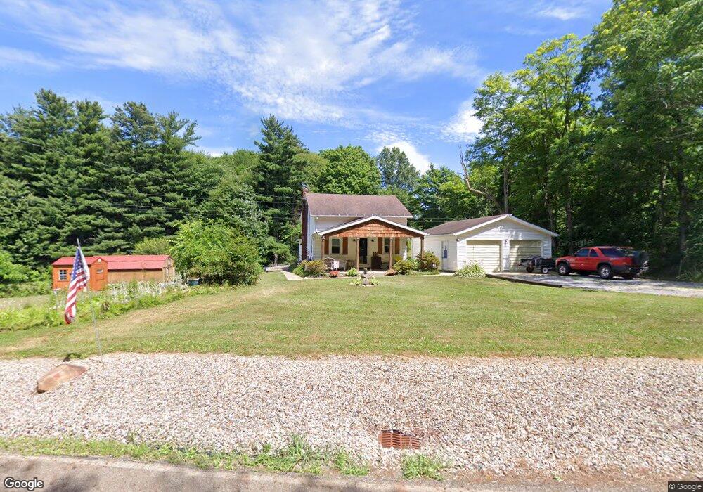
14044 Lair Rd NE Alliance, OH 44601
Estimated Value: $138,371 - $215,000
3
Beds
1
Bath
912
Sq Ft
$177/Sq Ft
Est. Value
About This Home
This home is located at 14044 Lair Rd NE, Alliance, OH 44601 and is currently estimated at $161,843, approximately $177 per square foot. 14044 Lair Rd NE is a home located in Stark County with nearby schools including Marlington High School.
Ownership History
Date
Name
Owned For
Owner Type
Purchase Details
Closed on
Apr 4, 2020
Sold by
Leech William W
Bought by
Leech William W and Leech Judith A
Current Estimated Value
Purchase Details
Closed on
Jan 18, 2006
Sold by
Leech William W and Leech Annette L
Bought by
Leech William W
Purchase Details
Closed on
Jul 22, 1994
Sold by
Robinson Robert W
Bought by
Leech William W and Leech Arnette
Home Financials for this Owner
Home Financials are based on the most recent Mortgage that was taken out on this home.
Original Mortgage
$43,200
Interest Rate
7.25%
Mortgage Type
New Conventional
Create a Home Valuation Report for This Property
The Home Valuation Report is an in-depth analysis detailing your home's value as well as a comparison with similar homes in the area
Home Values in the Area
Average Home Value in this Area
Purchase History
| Date | Buyer | Sale Price | Title Company |
|---|---|---|---|
| Leech William W | -- | None Available | |
| Leech William W | -- | None Available | |
| Leech William W | $45,500 | -- |
Source: Public Records
Mortgage History
| Date | Status | Borrower | Loan Amount |
|---|---|---|---|
| Closed | Leech William W | $43,200 |
Source: Public Records
Tax History Compared to Growth
Tax History
| Year | Tax Paid | Tax Assessment Tax Assessment Total Assessment is a certain percentage of the fair market value that is determined by local assessors to be the total taxable value of land and additions on the property. | Land | Improvement |
|---|---|---|---|---|
| 2025 | -- | $32,100 | $12,390 | $19,710 |
| 2024 | -- | $32,100 | $12,390 | $19,710 |
| 2023 | $1,046 | $29,680 | $11,480 | $18,200 |
| 2022 | $1,050 | $29,680 | $11,480 | $18,200 |
| 2021 | $1,053 | $29,680 | $11,480 | $18,200 |
| 2020 | $1,016 | $25,520 | $9,910 | $15,610 |
| 2019 | $1,009 | $25,520 | $9,910 | $15,610 |
| 2018 | $1,011 | $25,520 | $9,910 | $15,610 |
| 2017 | $902 | $21,330 | $5,220 | $16,110 |
| 2016 | $902 | $21,330 | $5,220 | $16,110 |
| 2015 | $899 | $22,210 | $5,570 | $16,640 |
| 2014 | $849 | $19,160 | $4,800 | $14,360 |
| 2013 | $422 | $19,160 | $4,800 | $14,360 |
Source: Public Records
Map
Nearby Homes
- German Church Street North E Unit LotWP001
- 0 German Church St NE
- 12415 Snode St NE
- 12252 Snode St NE
- 13975 Greenbower St NE
- 14350 Reeder Ave NE
- 12355 Edison St NE
- 13109 Edison St NE
- 11960 Freshley Ave NE
- 11940 Freshley Ave NE
- 5615 Laubert Rd
- 0 New Milford Rd Unit 5119787
- 11480 Aebi Ave NE
- 1015 Stroup Rd
- 14422 Sturbridge Rd NE
- 0 Knoll St NE
- 0 Klinger Ave NE
- 0 Meadow St NE
- 4829 Laubert Rd
- 10666 Wilma Ave NE
- 14091 Lair Rd NE
- 14041 Lair Rd NE
- 14100 Lair Rd NE
- 12127 Lair Rd NE
- 14204 Lair Rd NE
- 14245 Lair Rd NE
- 12320 Greenbower St NE
- 12052 Price St NE
- 99999 Greenbower St NE
- 12357 Greenbower St NE
- 12281 Greenbower St NE
- 11988 Price St NE
- 12283 Greenbower St NE
- 12415 Greenbower St NE
- 12040 Lair Rd NE
- 12471 Greenbower St NE
- 12487 Greenbower St NE
- 12254 Price St NE
- 12499 Greenbower St NE
- 12195 Price St NE