Estimated Value: $28,000 - $315,998
3
Beds
2
Baths
2,148
Sq Ft
$80/Sq Ft
Est. Value
About This Home
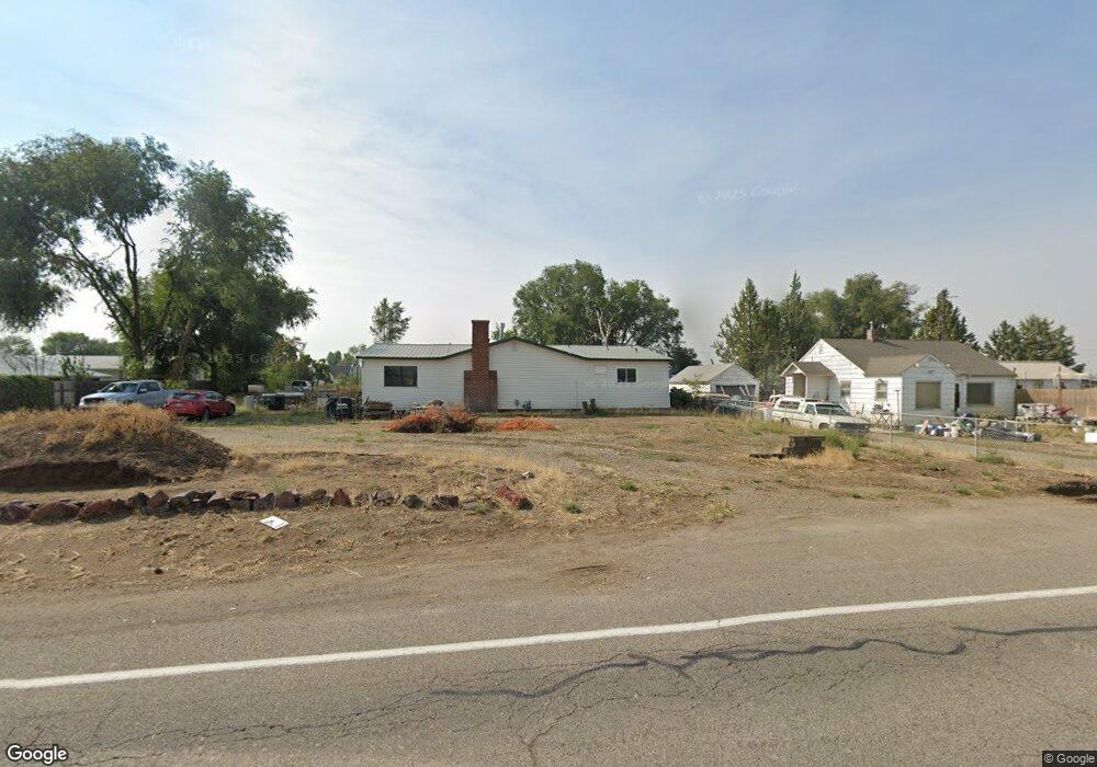
This home is located at 1405 Adrian Blvd, Nyssa, OR 97913 and is currently estimated at $171,999, approximately $80 per square foot. 1405 Adrian Blvd is a home located in Malheur County with nearby schools including Nyssa Elementary School, Nyssa Middle School, and Nyssa High School.
Ownership History
Date
Name
Owned For
Owner Type
Purchase Details
Closed on
Jan 18, 2018
Sold by
Federal National Mortgage Association
Bought by
May Winston Ora
Current Estimated Value
Home Financials for this Owner
Home Financials are based on the most recent Mortgage that was taken out on this home.
Original Mortgage
$125,000
Outstanding Balance
$104,992
Interest Rate
3.94%
Mortgage Type
New Conventional
Estimated Equity
$67,007
Purchase Details
Closed on
Jun 15, 2017
Sold by
Sarazin Julie Dee
Bought by
Ocwen Loan Servicing Llc
Create a Home Valuation Report for This Property
The Home Valuation Report is an in-depth analysis detailing your home's value as well as a comparison with similar homes in the area
Home Values in the Area
Average Home Value in this Area
Purchase History
| Date | Buyer | Sale Price | Title Company |
|---|---|---|---|
| May Winston Ora | $140,000 | Multiple | |
| Ocwen Loan Servicing Llc | $89,800 | None Available |
Source: Public Records
Mortgage History
| Date | Status | Borrower | Loan Amount |
|---|---|---|---|
| Open | May Winston Ora | $125,000 |
Source: Public Records
Tax History
| Year | Tax Paid | Tax Assessment Tax Assessment Total Assessment is a certain percentage of the fair market value that is determined by local assessors to be the total taxable value of land and additions on the property. | Land | Improvement |
|---|---|---|---|---|
| 2025 | $1,856 | $127,887 | $32,010 | $95,877 |
| 2024 | $1,828 | $124,163 | $34,885 | $89,278 |
| 2023 | $1,797 | $120,547 | $31,236 | $89,311 |
| 2022 | $1,797 | $117,036 | $32,189 | $84,847 |
| 2021 | $1,776 | $113,628 | $25,056 | $88,572 |
| 2020 | $1,740 | $110,319 | $26,902 | $83,417 |
| 2019 | $1,705 | $107,106 | $31,119 | $75,987 |
| 2018 | $1,632 | $103,987 | $30,213 | $73,774 |
| 2017 | $1,531 | $100,959 | $29,747 | $71,212 |
| 2016 | $1,557 | $98,019 | $26,130 | $71,889 |
| 2015 | $1,356 | $95,165 | $27,797 | $67,368 |
| 2014 | $1,485 | $92,394 | $25,905 | $66,489 |
Source: Public Records
Map
Nearby Homes
- 813 Reece Ave
- 617 Park Ave
- lot2 plat 2411 Oregon 201
- 904 Oak St Unit 44
- 416 N 2nd St
- 106 E Main St
- 110 E Main St
- 717 N 3rd St
- 108 E Main St
- 112 E Main St
- 705 N 2nd St
- 824 N 5th St
- 1770 N 3rd St
- 3091 Echo Rd
- TBD Sunset View Road (Lot 5)
- 28750 Rocky Rd
- 0 Leigh Ln
- 28650 Rocky Rd
- TBD Ada Ln
- 31854 Apple Valley Rd
- 1475 Adrian Blvd
- 1401 Adrian Blvd
- 1363 Adrian Blvd
- 450 Stringer Rd
- 1325 Adrian Blvd
- TBD Adrian Blvd
- 1408 Adrian Blvd
- 550 Stringer Rd
- 580 Stringer Rd
- 1403 Lovaas Ln
- 575 Stringer Rd
- 660 Stringer Rd
- 1 S Lovaas Ln
- 635 Stringer Rd
- 1380 Lovaas Ln
- 1 N Lovaas Ln
- 1300 Lovaas Ln
- 1100 Adrian Blvd
- 555 Beck Rd
- 1278 Lovaas Ln
Your Personal Tour Guide
Ask me questions while you tour the home.