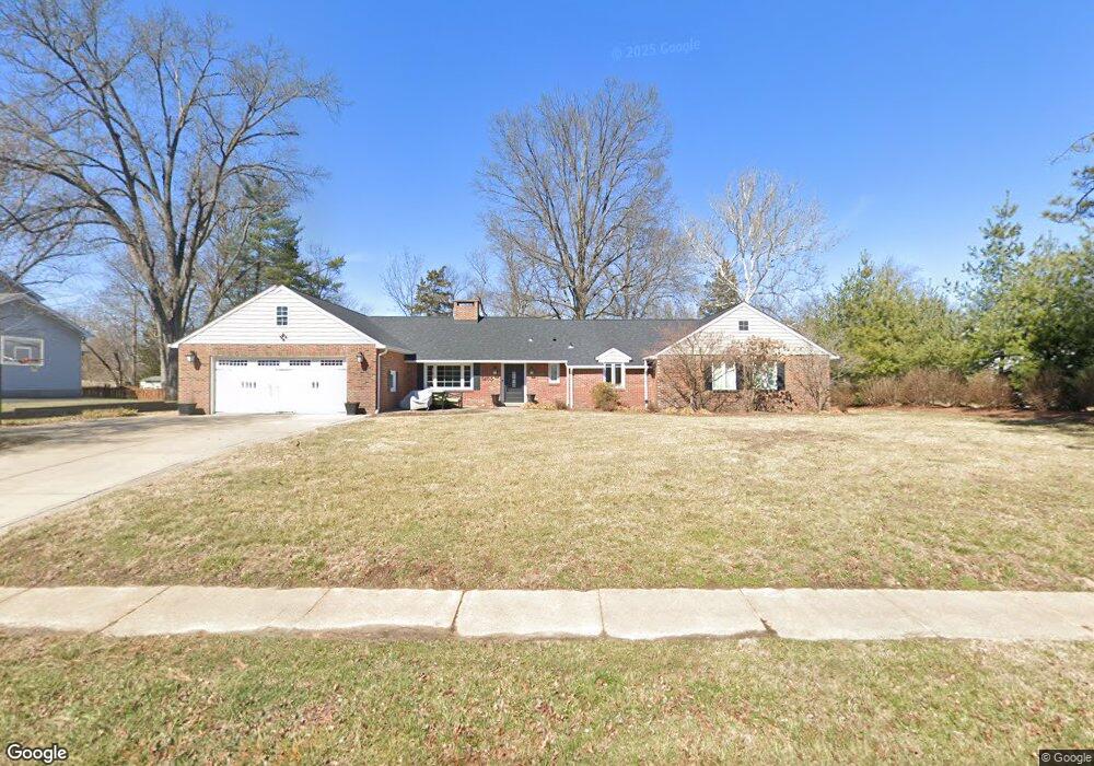
1405 Dougherty Ferry Rd Saint Louis, MO 63122
Estimated Value: $471,000 - $986,000
4
Beds
3
Baths
3,800
Sq Ft
$205/Sq Ft
Est. Value
About This Home
This home is located at 1405 Dougherty Ferry Rd, Saint Louis, MO 63122 and is currently estimated at $780,263, approximately $205 per square foot. 1405 Dougherty Ferry Rd is a home located in St. Louis County with nearby schools including W.W. Keysor Elementary School, North Kirkwood Middle School, and Kirkwood Senior High School.
Ownership History
Date
Name
Owned For
Owner Type
Purchase Details
Closed on
Dec 30, 2002
Sold by
Schaffner David E and Schaffner Ann Moon
Bought by
Schwent Matthew and Schwent Allison
Current Estimated Value
Home Financials for this Owner
Home Financials are based on the most recent Mortgage that was taken out on this home.
Original Mortgage
$158,320
Outstanding Balance
$67,125
Interest Rate
6.06%
Estimated Equity
$713,138
Purchase Details
Closed on
Mar 7, 2001
Sold by
Moon Mary K
Bought by
Schaffner David E and Schaffner Ann Moon
Create a Home Valuation Report for This Property
The Home Valuation Report is an in-depth analysis detailing your home's value as well as a comparison with similar homes in the area
Home Values in the Area
Average Home Value in this Area
Purchase History
| Date | Buyer | Sale Price | Title Company |
|---|---|---|---|
| Schwent Matthew | $197,900 | -- | |
| Schaffner David E | -- | -- |
Source: Public Records
Mortgage History
| Date | Status | Borrower | Loan Amount |
|---|---|---|---|
| Open | Schwent Matthew | $158,320 | |
| Closed | Schwent Matthew | $19,790 |
Source: Public Records
Tax History Compared to Growth
Tax History
| Year | Tax Paid | Tax Assessment Tax Assessment Total Assessment is a certain percentage of the fair market value that is determined by local assessors to be the total taxable value of land and additions on the property. | Land | Improvement |
|---|---|---|---|---|
| 2025 | $6,704 | $144,000 | $64,980 | $79,020 |
| 2024 | $6,704 | $107,260 | $44,670 | $62,590 |
| 2023 | $6,704 | $107,260 | $44,670 | $62,590 |
| 2022 | $6,522 | $98,920 | $44,670 | $54,250 |
| 2021 | $6,437 | $98,920 | $44,670 | $54,250 |
| 2020 | $6,290 | $92,940 | $33,740 | $59,200 |
| 2019 | $6,312 | $92,940 | $33,740 | $59,200 |
| 2018 | $5,967 | $77,590 | $25,020 | $52,570 |
| 2017 | $5,959 | $77,590 | $25,020 | $52,570 |
| 2016 | $6,145 | $80,650 | $21,600 | $59,050 |
| 2015 | $6,115 | $80,650 | $21,600 | $59,050 |
| 2014 | $7,085 | $91,470 | $18,150 | $73,320 |
Source: Public Records
Map
Nearby Homes
- 1312 W Essex Ave
- 1710 Lynkirk Ln
- 1422 Northlin Dr
- 425 Gabriel Dr
- 11909 Lillian Ave
- 919 Nana Ln
- 11913 Lillian Ave
- 1314 W Adams Ave
- 1001 Dovergate Dr
- 2002 Woodland Knoll
- 2005 Woodland Knoll
- 2017 Woodland Knoll
- 946 Rochdale Dr
- 456 Wilcox Ave
- 2025 Woodland Knoll
- 2033 Woodland Knoll
- 896 Twin Pine Dr
- 699 W Washington Ave
- 531 Goethe Ave
- 537 Goethe Ave
- 1411 Dougherty Ferry Rd
- 1414 Frances Rd
- 708 Colonial Oak Ln
- 1417 Dougherty Ferry Rd
- 1253 Dougherty Ferry Rd
- 1440 Frances Rd
- 1336 Dougherty Ferry Rd
- 709 Colonial Oak Ln
- 1425 Dougherty Ferry Rd
- 716 Colonial Oak Ln
- 1447 Frances Rd
- 1465 Frances Rd
- 1243 Dougherty Ferry Rd
- 1505 Cornhill Ln
- 724 Colonial Oak Ln
- 1450 Frances Rd
- 1313 W Essex Ave
- 1316 W Essex Ave
- 1318 Dougherty Ferry Rd
- 1448 Oak Bluff Ln