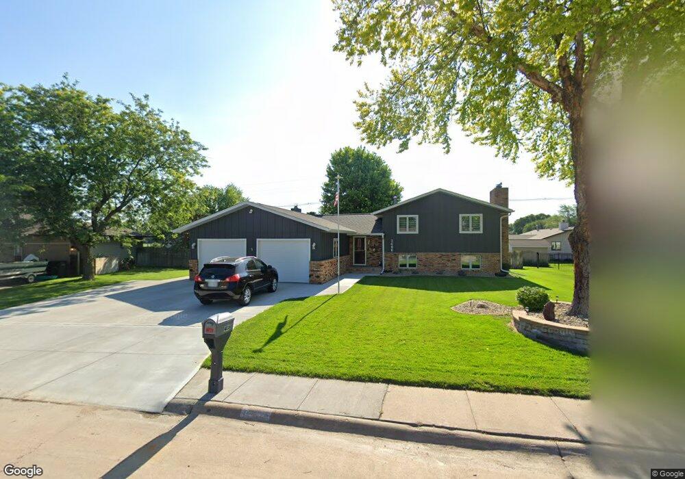
1406 Apache Ave Hastings, NE 68901
Estimated Value: $324,883 - $383,000
3
Beds
3
Baths
1,504
Sq Ft
$239/Sq Ft
Est. Value
About This Home
This home is located at 1406 Apache Ave, Hastings, NE 68901 and is currently estimated at $358,971, approximately $238 per square foot. 1406 Apache Ave is a home located in Adams County with nearby schools including Hastings Senior High School, St. Michael's Preschool & Elementary School, and Zion Lutheran School.
Ownership History
Date
Name
Owned For
Owner Type
Purchase Details
Closed on
Jun 28, 2020
Sold by
Streufert Joseph Dale and Streufert Brindi Kay
Bought by
Armes Meleah K
Current Estimated Value
Purchase Details
Closed on
Feb 9, 2017
Sold by
Freeburger James D and Freeburger Debra S
Bought by
Streufert Joseph Dale and Streufert Brindi Kay
Home Financials for this Owner
Home Financials are based on the most recent Mortgage that was taken out on this home.
Original Mortgage
$204,000
Interest Rate
4.12%
Mortgage Type
New Conventional
Create a Home Valuation Report for This Property
The Home Valuation Report is an in-depth analysis detailing your home's value as well as a comparison with similar homes in the area
Home Values in the Area
Average Home Value in this Area
Purchase History
| Date | Buyer | Sale Price | Title Company |
|---|---|---|---|
| Armes Meleah K | $285,000 | None Available | |
| Streufert Joseph Dale | $256,000 | Adams Land Title Company |
Source: Public Records
Mortgage History
| Date | Status | Borrower | Loan Amount |
|---|---|---|---|
| Previous Owner | Streufert Joseph Dale | $204,000 |
Source: Public Records
Tax History
| Year | Tax Paid | Tax Assessment Tax Assessment Total Assessment is a certain percentage of the fair market value that is determined by local assessors to be the total taxable value of land and additions on the property. | Land | Improvement |
|---|---|---|---|---|
| 2025 | $4,606 | $294,608 | $33,000 | $261,608 |
| 2024 | $4,776 | $294,608 | $33,000 | $261,608 |
| 2023 | $5,269 | $255,367 | $33,000 | $222,367 |
| 2022 | $6,253 | $277,576 | $33,000 | $244,576 |
| 2021 | $6,027 | $274,826 | $30,250 | $244,576 |
| 2020 | $4,065 | $188,505 | $30,250 | $158,255 |
| 2019 | $4,021 | $188,505 | $30,250 | $158,255 |
| 2018 | $3,866 | $180,255 | $22,000 | $158,255 |
| 2017 | $3,796 | $177,150 | $0 | $0 |
| 2016 | $3,582 | $167,000 | $22,000 | $145,000 |
| 2011 | -- | $155,160 | $19,800 | $135,360 |
Source: Public Records
Map
Nearby Homes
- 1406 Sheridan Place
- 1401 Heritage Dr
- 1225 Heritage Dr
- 1233 Heritage Dr
- 1720 Apache Ave
- 1250 Heritage Place
- 1253 Westridge Dr
- 1105 Jefferson Ave
- 1909 W 10th St
- 1934 W 9th St
- 2019 W 9th St
- 910 Jefferson Ave
- 736 N Barnes Ave
- 1334 W 12th St
- 1810 W 8th St
- 2412 W 8th St
- 1831 W 8th St
- 1701 Boyce St
- 2301 Bateman Ave
- 2603 Bateman St
- 1414 Apache Ave
- 1402 Apache Ave
- 1413 Crane Ave
- 2000 W 14th St
- 1420 Apache Ave
- 1405 Apache Ave
- 1401 Apache Ave
- 1415 Apache Ave
- 1340 Apache Ave
- 1421 Apache Ave
- 1406 Crane Ave
- 1406 Arapahoe Ave
- 1339 Apache Ave
- 1424 Crane Ave
- 1936 W 14th St Unit 1938
- 1506 Apache Ave
- 1332 Apache Ave
- 1501 Apache Ave
- 1410 Arapahoe Ave
- 1331 Apache Ave
Your Personal Tour Guide
Ask me questions while you tour the home.