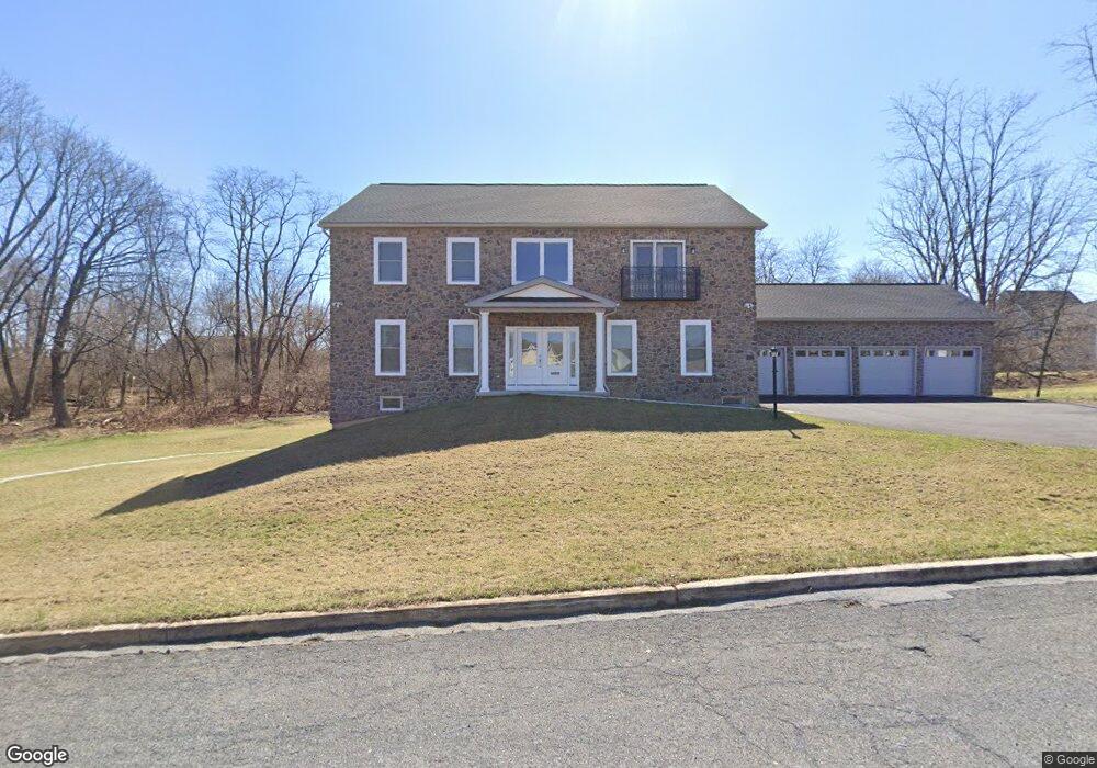
1406 Gregg St Reading, PA 19607
Liggett NeighborhoodEstimated Value: $468,000 - $817,000
6
Beds
6
Baths
3,800
Sq Ft
$156/Sq Ft
Est. Value
About This Home
This home is located at 1406 Gregg St, Reading, PA 19607 and is currently estimated at $594,499, approximately $156 per square foot. 1406 Gregg St is a home located in Berks County with nearby schools including Millmont Elementary School, Central Middle School, and Reading Senior High School.
Ownership History
Date
Name
Owned For
Owner Type
Purchase Details
Closed on
Sep 13, 2019
Sold by
Elmarzouky Elsayed
Bought by
Kebbay Noahleen Betts
Current Estimated Value
Purchase Details
Closed on
Aug 22, 2018
Sold by
Elmarzouky Elsayed and Youssef Alaa
Bought by
Elmarzouky Elsayed
Purchase Details
Closed on
Jun 3, 2008
Sold by
Mescavage Michael J F
Bought by
Elmarzouky Elsayed and Youssef Alaa
Create a Home Valuation Report for This Property
The Home Valuation Report is an in-depth analysis detailing your home's value as well as a comparison with similar homes in the area
Home Values in the Area
Average Home Value in this Area
Purchase History
| Date | Buyer | Sale Price | Title Company |
|---|---|---|---|
| Kebbay Noahleen Betts | $55,000 | First Amer Abstract Wyomissi | |
| Elmarzouky Elsayed | $25,623 | Conestoga Title Insurance | |
| Elmarzouky Elsayed | $80,000 | First American Title Insuran |
Source: Public Records
Tax History Compared to Growth
Tax History
| Year | Tax Paid | Tax Assessment Tax Assessment Total Assessment is a certain percentage of the fair market value that is determined by local assessors to be the total taxable value of land and additions on the property. | Land | Improvement |
|---|---|---|---|---|
| 2025 | $6,943 | $255,800 | $45,500 | $210,300 |
| 2024 | $1,559 | $35,100 | $35,100 | -- |
| 2023 | $1,534 | $35,100 | $35,100 | $0 |
| 2022 | $1,534 | $35,100 | $35,100 | $0 |
| 2021 | $1,534 | $35,100 | $35,100 | $0 |
| 2020 | $1,519 | $35,100 | $35,100 | $0 |
| 2019 | $1,519 | $35,100 | $35,100 | $0 |
| 2018 | $1,519 | $35,100 | $35,100 | $0 |
| 2017 | $2,085 | $48,500 | $48,500 | $0 |
| 2016 | $1,191 | $48,500 | $48,500 | $0 |
| 2015 | $1,191 | $48,500 | $48,500 | $0 |
| 2014 | $1,096 | $48,500 | $48,500 | $0 |
Source: Public Records
Map
Nearby Homes
- 1407 Lancaster Ave
- 1501 Gregg Ave
- 1432 Liggett Ave
- 1530 Liggett Ave
- 1355 Liggett Ave
- 617 Meade Tc
- 524 Pershing Blvd
- 1207 Scott St
- 1602 Crowder Ave
- 1020 Meade St
- 15 Bare Ave
- 602 Harding Ave
- 979 New Holland Rd
- 1531 Fayette Ave
- 123 High Blvd
- 1609 Fayette Ave
- 429 Devon Terrace
- 1202 Old Mill Rd
- 511 Grill Ave
- 1424 Commonwealth Blvd
- 1406 Gregg Ave
- 1420 Gregg St
- 1420 Gregg Ave
- 1426 Gregg Ave
- 1426 Gregg St
- 1415 Gregg Ave
- 10 Mcarthur Ave
- 1417 Gregg Ave
- 1407 Gregg Ave
- 1440 Gregg Ave
- 1440 Gregg St
- 1425 Gregg Ave
- 19 Funston Ave
- 1431 Gregg Ave
- 1409 Lancaster Ave
- 1419 Lancaster Ave
- 1401 Lancaster Ave
- 1441 Gregg Ave
- 1441 Gregg St
- 1413 Lancaster Ave