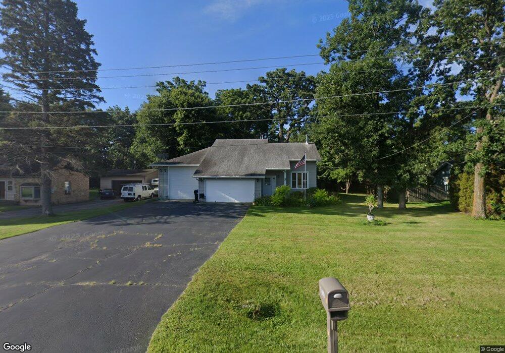
1409 Main Street Rd Spring Grove, IL 60081
Estimated Value: $305,000 - $363,000
--
Bed
--
Bath
1,728
Sq Ft
$188/Sq Ft
Est. Value
About This Home
This home is located at 1409 Main Street Rd, Spring Grove, IL 60081 and is currently estimated at $325,594, approximately $188 per square foot. 1409 Main Street Rd is a home located in McHenry County with nearby schools including Spring Grove Elementary School, Nippersink Middle School, and Richmond-Burton High School.
Ownership History
Date
Name
Owned For
Owner Type
Purchase Details
Closed on
Jan 14, 2019
Sold by
Viscioni Aaron
Bought by
First Nations Bank
Current Estimated Value
Purchase Details
Closed on
Jul 23, 2018
Sold by
Hopkins Wayne A and Fryer Hopkins Janice E
Bought by
Viscioni Aaron
Purchase Details
Closed on
Sep 3, 1993
Sold by
Miller Louis D
Bought by
Miller Dorothy A
Create a Home Valuation Report for This Property
The Home Valuation Report is an in-depth analysis detailing your home's value as well as a comparison with similar homes in the area
Home Values in the Area
Average Home Value in this Area
Purchase History
| Date | Buyer | Sale Price | Title Company |
|---|---|---|---|
| First Nations Bank | -- | Attorney | |
| Viscioni Aaron | $222,000 | Blackacre Title Svcs | |
| Miller Dorothy A | $110,000 | -- |
Source: Public Records
Tax History Compared to Growth
Tax History
| Year | Tax Paid | Tax Assessment Tax Assessment Total Assessment is a certain percentage of the fair market value that is determined by local assessors to be the total taxable value of land and additions on the property. | Land | Improvement |
|---|---|---|---|---|
| 2024 | $5,878 | $89,780 | $5,272 | $84,508 |
| 2023 | $5,830 | $83,734 | $4,917 | $78,817 |
| 2022 | $5,522 | $73,657 | $4,325 | $69,332 |
| 2021 | $5,238 | $69,435 | $4,077 | $65,358 |
| 2020 | $5,113 | $66,375 | $3,897 | $62,478 |
| 2019 | $5,148 | $65,342 | $3,836 | $61,506 |
| 2018 | $4,796 | $63,322 | $3,717 | $59,605 |
| 2017 | $4,691 | $59,462 | $3,490 | $55,972 |
| 2016 | $5,189 | $56,787 | $3,333 | $53,454 |
| 2013 | -- | $59,631 | $2,649 | $56,982 |
Source: Public Records
Map
Nearby Homes
- Lot 65 & 66 Main Street Rd
- 7710 Ravina Dr
- Lot 64 Beverly Way
- Lot 61 Beverly Way
- Lot 60 Beverly Way
- Lot 59 Beverly Way
- Lot 58 Beverly Way
- Lot 57 Beverly Way
- LOT 56 Beverly Way
- 1410 Linden Rd
- LOT 9 Mayo Ct
- 1852 Red Oak Ln
- 1876 Red Oak Ln
- 1975 Red Oak Ln
- 1848 Red Oak Ln
- 1979 Red Oak Ln
- Lot 36 Red Oak Ln
- LOT 40 Red Oak Ln
- 1971 Red Oak Ln
- 7392 English Oak Ln
- 1409 Main St Rd
- 1413 Main Street Rd
- 1413 Main Street Rd
- 1407 Main Street Rd
- 1417 Main Street Rd
- 1408 Woodland Pkwy
- 1414 Woodland Pkwy
- 1416 Woodland Pkwy
- 1418 Woodland Pkwy
- 1419 Main Street Rd
- 1405 Main Street Rd
- 7715 Ravina Dr
- 7715 Ravina Dr
- 1420 Woodland Pkwy
- 7808 River Dr
- 1407 Woodland Pkwy
- 1403 Woodland Pkwy
- 1415 Woodland Pkwy
- 1317 Main Street Rd
- 1421 Woodland Pkwy