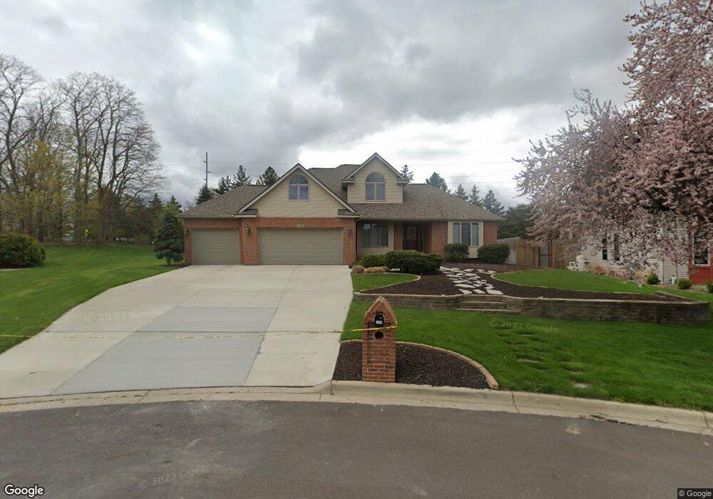
1409 Strawflower Cir Lansing, MI 48917
Estimated Value: $377,000 - $444,000
4
Beds
4
Baths
2,252
Sq Ft
$179/Sq Ft
Est. Value
About This Home
This home is located at 1409 Strawflower Cir, Lansing, MI 48917 and is currently estimated at $402,540, approximately $178 per square foot. 1409 Strawflower Cir is a home located in Eaton County with nearby schools including Willow Ridge Elementary School, Leon W. Hayes Middle School, and Grand Ledge High School.
Ownership History
Date
Name
Owned For
Owner Type
Purchase Details
Closed on
Jun 4, 2025
Sold by
Buckmaster Robert W and Buckmaster Julie M
Bought by
Buckmaster Robert W and Buckmaster Julie M
Current Estimated Value
Create a Home Valuation Report for This Property
The Home Valuation Report is an in-depth analysis detailing your home's value as well as a comparison with similar homes in the area
Home Values in the Area
Average Home Value in this Area
Purchase History
| Date | Buyer | Sale Price | Title Company |
|---|---|---|---|
| Buckmaster Robert W | -- | None Listed On Document |
Source: Public Records
Tax History Compared to Growth
Tax History
| Year | Tax Paid | Tax Assessment Tax Assessment Total Assessment is a certain percentage of the fair market value that is determined by local assessors to be the total taxable value of land and additions on the property. | Land | Improvement |
|---|---|---|---|---|
| 2025 | $6,324 | $210,900 | $0 | $0 |
| 2024 | $3,139 | $198,100 | $0 | $0 |
| 2023 | $2,924 | $184,600 | $0 | $0 |
| 2022 | $5,391 | $171,600 | $0 | $0 |
| 2021 | $5,160 | $166,400 | $0 | $0 |
| 2020 | $5,072 | $156,000 | $0 | $0 |
| 2019 | $4,987 | $151,656 | $0 | $0 |
| 2018 | $4,687 | $147,700 | $0 | $0 |
| 2017 | $4,591 | $139,300 | $0 | $0 |
| 2016 | -- | $133,600 | $0 | $0 |
| 2015 | -- | $126,500 | $0 | $0 |
| 2014 | -- | $119,786 | $0 | $0 |
| 2013 | -- | $117,900 | $0 | $0 |
Source: Public Records
Map
Nearby Homes
- 6512 Spring Tree Ln Unit 14
- 6542 Brook Trail
- 6531 Windsong Way
- 6725 French Creek Dr
- 5910 Cabrena Dr
- 1108 Summergreen Ln Unit 103
- 1120 Rolling Green Ln
- 1527 Lindy Dr
- 6361 Larocque Cir
- 6333 Larocque Cir
- 1205 Woodmeadow Unit 201
- 1106 S Ridge Rd
- 1738 Willow Creek Dr Unit 63
- 5754 River Ridge Dr
- 1909 Redbud Ln Unit 3
- 1516 Elmwood Rd
- 2212 Holiday Ln
- 5030 Grape Arbor Ln
- 1031 Mall Dr E
- 5201 Greenbriar Rd
- 1415 Strawflower Cir
- 1403 Strawflower Cir
- 6343 Blue Stone Dr
- 6337 Blue Stone Dr
- 1329 N Creyts Rd
- 1404 Strawflower Cir
- 1337 N Creyts Rd
- 1321 N Creyts Rd
- 1416 Strawflower Cir
- 1408 Strawflower Cir
- 1313 N Creyts Rd
- 6321 Blue Stone Dr
- 1232 N Creyts Rd
- 1314 Wolf Run Dr
- 0 N Creyts Rd
- 1320 Wolf Run Dr
- 1401 Settlers Hill Dr
- 6311 Blue Stone Dr
- 1326 Wolf Run Dr
- 1306 Wolf Run Dr