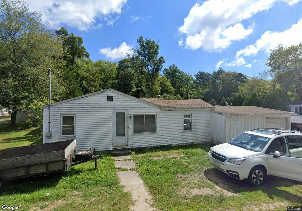
141 Braley Rd East Freetown, MA 02717
Estimated Value: $355,000 - $424,000
2
Beds
1
Bath
819
Sq Ft
$472/Sq Ft
Est. Value
About This Home
This home is located at 141 Braley Rd, East Freetown, MA 02717 and is currently estimated at $386,792, approximately $472 per square foot. 141 Braley Rd is a home located in Bristol County with nearby schools including Freetown Elementary School, George R Austin Intermediate School, and Freetown-Lakeville Middle School.
Ownership History
Date
Name
Owned For
Owner Type
Purchase Details
Closed on
Aug 23, 2004
Sold by
Moniz Manuel
Bought by
Hammerle Casey and Pittsley Floyd F
Current Estimated Value
Home Financials for this Owner
Home Financials are based on the most recent Mortgage that was taken out on this home.
Original Mortgage
$155,900
Outstanding Balance
$77,463
Interest Rate
6.03%
Mortgage Type
Purchase Money Mortgage
Estimated Equity
$309,329
Purchase Details
Closed on
Feb 10, 1994
Sold by
Nuttall Richard P
Bought by
Moniz Manuel
Home Financials for this Owner
Home Financials are based on the most recent Mortgage that was taken out on this home.
Original Mortgage
$65,000
Interest Rate
7.08%
Mortgage Type
Purchase Money Mortgage
Create a Home Valuation Report for This Property
The Home Valuation Report is an in-depth analysis detailing your home's value as well as a comparison with similar homes in the area
Home Values in the Area
Average Home Value in this Area
Purchase History
| Date | Buyer | Sale Price | Title Company |
|---|---|---|---|
| Hammerle Casey | $194,900 | -- | |
| Moniz Manuel | $70,000 | -- |
Source: Public Records
Mortgage History
| Date | Status | Borrower | Loan Amount |
|---|---|---|---|
| Open | Moniz Manuel | $155,900 | |
| Closed | Moniz Manuel | $39,000 | |
| Previous Owner | Moniz Manuel | $65,000 | |
| Previous Owner | Moniz Manuel | $20,000 |
Source: Public Records
Tax History Compared to Growth
Tax History
| Year | Tax Paid | Tax Assessment Tax Assessment Total Assessment is a certain percentage of the fair market value that is determined by local assessors to be the total taxable value of land and additions on the property. | Land | Improvement |
|---|---|---|---|---|
| 2025 | $2,847 | $287,300 | $155,000 | $132,300 |
| 2024 | $2,829 | $271,200 | $146,200 | $125,000 |
| 2023 | $2,711 | $253,100 | $131,700 | $121,400 |
| 2022 | $2,583 | $214,200 | $111,600 | $102,600 |
| 2021 | $2,475 | $194,900 | $101,400 | $93,500 |
| 2020 | $2,411 | $185,200 | $97,600 | $87,600 |
| 2019 | $2,289 | $174,100 | $92,900 | $81,200 |
| 2018 | $2,205 | $165,700 | $92,900 | $72,800 |
| 2017 | $2,163 | $162,400 | $92,900 | $69,500 |
| 2016 | $2,063 | $157,600 | $90,200 | $67,400 |
| 2015 | $1,881 | $145,800 | $90,200 | $55,600 |
| 2014 | $1,784 | $141,500 | $88,400 | $53,100 |
Source: Public Records
Map
Nearby Homes
- 0 Costa Dr
- 1599 Braley Rd Unit 68
- 1573 Braley Rd Unit 39
- 595 Quanapoag Rd
- 599 Quanapoag Rd
- 4597 Acushnet Ave
- 3 Elaine Ave
- 13 Luscomb Ln
- 16 Swallow St
- 23 Parker Dr
- 1069 Cherokee St
- 11 Gurney Rd
- 64 Blaze Rd
- 144 Chace Rd
- 122 Quanapoag Rd
- 26 Blueberry Dr
- 34 Poplar Rd
- 210 Heritage Dr
- 145 Heritage Dr
- 150 Quanapoag Rd