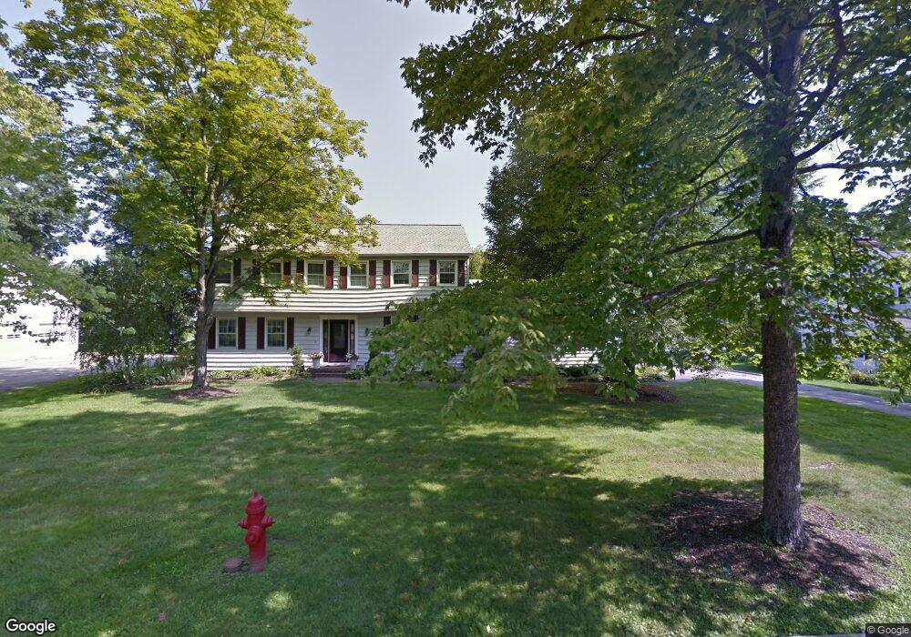
141 Colony Dr Hudson, OH 44236
Estimated Value: $433,935 - $516,000
4
Beds
3
Baths
2,450
Sq Ft
$197/Sq Ft
Est. Value
About This Home
This home is located at 141 Colony Dr, Hudson, OH 44236 and is currently estimated at $482,984, approximately $197 per square foot. 141 Colony Dr is a home located in Summit County with nearby schools including Ellsworth Hill Elementary School, East Woods Intermediate School, and Hudson Middle School.
Ownership History
Date
Name
Owned For
Owner Type
Purchase Details
Closed on
Sep 17, 2025
Sold by
Johnson Melanie S and Johnson Eric D
Bought by
Eric D Johnson And Melanie S Johnson Living T and Johnson
Current Estimated Value
Purchase Details
Closed on
Mar 25, 2010
Sold by
Johnson Melanie S and Nelson Melanie S
Bought by
Johnson Melanie S and Johnson Eric D
Home Financials for this Owner
Home Financials are based on the most recent Mortgage that was taken out on this home.
Original Mortgage
$160,000
Interest Rate
4.96%
Mortgage Type
New Conventional
Purchase Details
Closed on
Jul 23, 2008
Sold by
Johnson Rob Andrew
Bought by
Nelson Melanie S
Home Financials for this Owner
Home Financials are based on the most recent Mortgage that was taken out on this home.
Original Mortgage
$200,000
Interest Rate
5.54%
Mortgage Type
Purchase Money Mortgage
Purchase Details
Closed on
Oct 22, 2004
Sold by
Schultz Albert C and Schultz Charlotte M
Bought by
Johnson Andrew and Rob Andrew Johnson Revocable Trust
Create a Home Valuation Report for This Property
The Home Valuation Report is an in-depth analysis detailing your home's value as well as a comparison with similar homes in the area
Home Values in the Area
Average Home Value in this Area
Purchase History
| Date | Buyer | Sale Price | Title Company |
|---|---|---|---|
| Eric D Johnson And Melanie S Johnson Living T | -- | None Listed On Document | |
| Johnson Melanie S | -- | Title First Agency Inc | |
| Nelson Melanie S | $287,000 | Revere Title Summit County | |
| Johnson Andrew | $193,762 | Revere Title |
Source: Public Records
Mortgage History
| Date | Status | Borrower | Loan Amount |
|---|---|---|---|
| Previous Owner | Johnson Melanie S | $160,000 | |
| Previous Owner | Nelson Melanie S | $200,000 |
Source: Public Records
Tax History Compared to Growth
Tax History
| Year | Tax Paid | Tax Assessment Tax Assessment Total Assessment is a certain percentage of the fair market value that is determined by local assessors to be the total taxable value of land and additions on the property. | Land | Improvement |
|---|---|---|---|---|
| 2025 | $6,026 | $117,989 | $18,680 | $99,309 |
| 2024 | $6,026 | $117,989 | $18,680 | $99,309 |
| 2023 | $6,026 | $117,989 | $18,680 | $99,309 |
| 2021 | $4,941 | $91,620 | $14,480 | $77,140 |
| 2020 | $5,166 | $91,620 | $14,480 | $77,140 |
| 2019 | $5,379 | $88,360 | $16,390 | $71,970 |
| 2018 | $5,360 | $88,360 | $16,390 | $71,970 |
| 2017 | $4,624 | $88,360 | $16,390 | $71,970 |
| 2016 | $4,729 | $75,110 | $16,390 | $58,720 |
| 2015 | $4,624 | $75,110 | $16,390 | $58,720 |
| 2014 | $4,637 | $75,110 | $16,390 | $58,720 |
| 2013 | $4,461 | $70,570 | $16,390 | $54,180 |
Source: Public Records
Map
Nearby Homes
- 148 Colony Dr
- 5974 Anna Lee Dr
- 21 Keswick Dr
- 94 Fox Trace Ln
- 5937 Ogilby Dr
- 5791 Sunset Dr
- 1705 Barlow Rd
- 35 S Hayden Pkwy
- 21 Atterbury Blvd
- 116 W Case Dr
- 157 Hudson St
- 77 Atterbury Blvd Unit 106
- 5532 Hudson Dr
- 311 W Streetsboro St
- 181 Boston Mills Rd
- 180 Atterbury Blvd
- 6607 Dunbarton Dr
- 24 Morning Song Ln
- 2380 Victoria Pkwy
- 6751 Pheasants Ridge
- 135 Colony Dr
- 149 Colony Dr
- 140 Clairhaven Dr
- 132 Clairhaven Dr
- 146 Clairhaven Dr
- 142 Colony Dr
- 127 Colony Dr
- 155 Colony Dr
- 134 Colony Dr
- 126 Clairhaven Dr
- 154 Clairhaven Dr
- 128 Colony Dr
- 156 Colony Dr
- 119 Colony Dr
- 118 Clairhaven Dr
- 137 Clairhaven Dr
- 1973 Stoney Hill Dr
- 145 Clairhaven Dr
- 120 Colony Dr
- 1985 Stoney Hill Dr