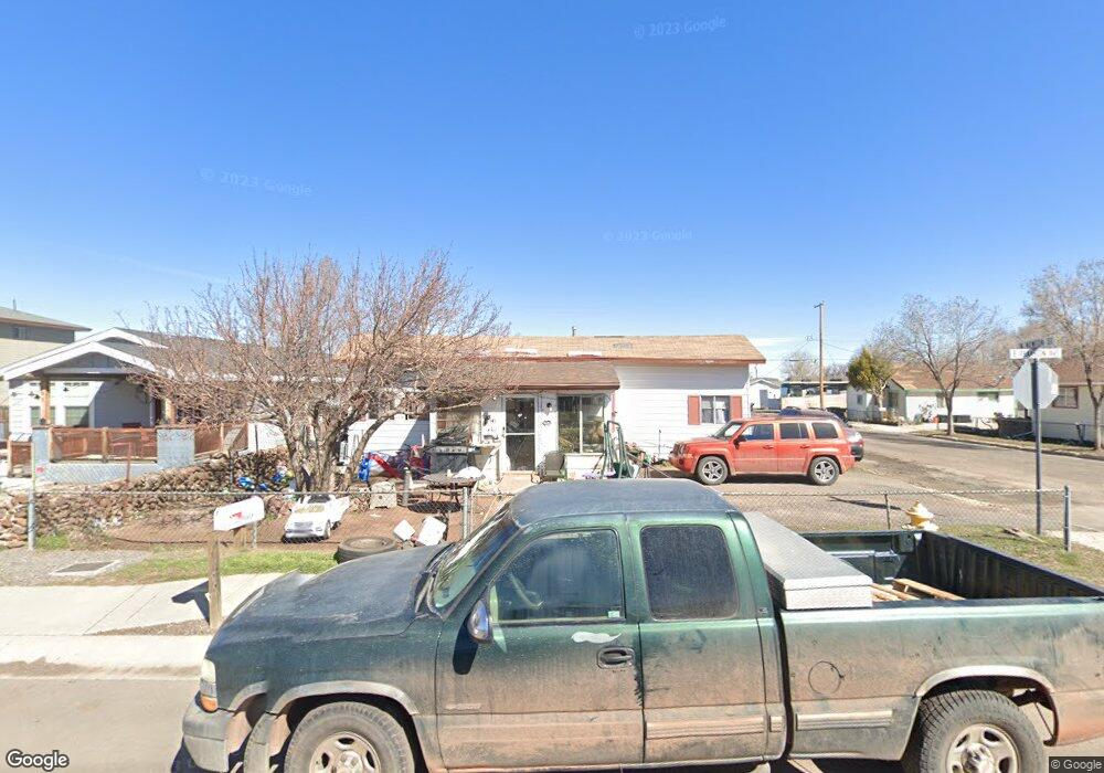
141 E Franklin Ave Williams, AZ 86046
Estimated Value: $303,096 - $495,000
--
Bed
--
Bath
1,730
Sq Ft
$229/Sq Ft
Est. Value
About This Home
This home is located at 141 E Franklin Ave, Williams, AZ 86046 and is currently estimated at $395,774, approximately $228 per square foot. 141 E Franklin Ave is a home located in Coconino County with nearby schools including Williams Elementary/Middle School, Williams High School, and Heritage Elementary - Williams.
Ownership History
Date
Name
Owned For
Owner Type
Purchase Details
Closed on
Sep 3, 2024
Sold by
Martinez Sharon Kay and Martinez Jose
Bought by
Galvan Elaina Kay
Current Estimated Value
Purchase Details
Closed on
Apr 24, 1996
Sold by
Estrada Faustino and Estrada Judith L
Bought by
Dorris Sharon K and Martinez Jose C
Home Financials for this Owner
Home Financials are based on the most recent Mortgage that was taken out on this home.
Original Mortgage
$24,000
Interest Rate
8.25%
Mortgage Type
New Conventional
Create a Home Valuation Report for This Property
The Home Valuation Report is an in-depth analysis detailing your home's value as well as a comparison with similar homes in the area
Home Values in the Area
Average Home Value in this Area
Purchase History
| Date | Buyer | Sale Price | Title Company |
|---|---|---|---|
| Galvan Elaina Kay | -- | None Listed On Document | |
| Dorris Sharon K | $30,000 | Pioneer Title Agency |
Source: Public Records
Mortgage History
| Date | Status | Borrower | Loan Amount |
|---|---|---|---|
| Previous Owner | Dorris Sharon K | $24,000 | |
| Closed | Dorris Sharon K | $3,000 |
Source: Public Records
Tax History
| Year | Tax Paid | Tax Assessment Tax Assessment Total Assessment is a certain percentage of the fair market value that is determined by local assessors to be the total taxable value of land and additions on the property. | Land | Improvement |
|---|---|---|---|---|
| 2025 | $689 | $22,596 | -- | -- |
| 2024 | $689 | $21,616 | -- | -- |
| 2023 | $666 | $16,463 | $0 | $0 |
| 2022 | $628 | $13,039 | $0 | $0 |
| 2021 | $612 | $12,688 | $0 | $0 |
| 2020 | $598 | $10,608 | $0 | $0 |
| 2019 | $580 | $9,351 | $0 | $0 |
| 2018 | $557 | $8,298 | $0 | $0 |
| 2017 | $550 | $7,241 | $0 | $0 |
| 2016 | $518 | $6,701 | $0 | $0 |
| 2015 | $547 | $6,915 | $0 | $0 |
Source: Public Records
Map
Nearby Homes
- 218 E Edison Ave
- 00 S Pine St
- 344 E Route 66
- 1124 N Grand Canyon Blvd Unit C
- 701 N Airport Rd
- 241 W Grant Ave
- 401 S 1st St
- 304 S 4th St
- 1105 W Morse Ave
- 216 Pinecrest Trail
- 500 W Meade Ave
- 162 Pinecrest Trail
- 118 Pinecrest Trail
- 1258 W Morse Ave
- 215 W Hancock Ave
- 147 Pinecrest Trail
- 224 N Morse Ave
- 920 W Sheridan Ave
- 1011 W Sheridan Ave
- 1021 W Sheridan Ave
- 133 E Franklin Ave
- 203 E Franklin Ave
- 125 E Franklin Ave
- 0 E Franklin Ave
- 410 N Newton St
- 205 E Franklin Ave
- 124 E Fulton Ave
- 117 E Franklin Ave
- 117 E Franklin Ave
- 142 E Fulton Ave
- 134 E Fulton Ave
- 126 E Fulton Ave
- 122 E Fulton Ave
- 105 E Franklin Ave
- 202 E Fulton Ave
- 410 S 1st St
- 410 N 1st St
- 210 E Fulton Ave
- 214 E Fulton Ave
- 225 E Franklin Ave
Your Personal Tour Guide
Ask me questions while you tour the home.