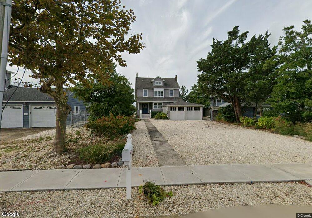
141 Pershing Blvd Lavallette, NJ 08735
Estimated Value: $2,385,000 - $3,533,000
3
Beds
3
Baths
3,463
Sq Ft
$827/Sq Ft
Est. Value
About This Home
This home is located at 141 Pershing Blvd, Lavallette, NJ 08735 and is currently estimated at $2,863,757, approximately $826 per square foot. 141 Pershing Blvd is a home located in Ocean County with nearby schools including Lavallette Elementary School.
Ownership History
Date
Name
Owned For
Owner Type
Purchase Details
Closed on
Jul 18, 2018
Sold by
Rothman Carol Ann
Bought by
Rothman Living Trust
Current Estimated Value
Purchase Details
Closed on
Apr 28, 2006
Sold by
Liske Rothman Carol A and Rothman Paul A
Bought by
Rothman Paul A and The Paul A Rothman Living Trust
Create a Home Valuation Report for This Property
The Home Valuation Report is an in-depth analysis detailing your home's value as well as a comparison with similar homes in the area
Home Values in the Area
Average Home Value in this Area
Purchase History
| Date | Buyer | Sale Price | Title Company |
|---|---|---|---|
| Rothman Living Trust | -- | None Available | |
| Rothman Carol Ann | -- | None Available | |
| Rothman Paul A | -- | None Available |
Source: Public Records
Tax History Compared to Growth
Tax History
| Year | Tax Paid | Tax Assessment Tax Assessment Total Assessment is a certain percentage of the fair market value that is determined by local assessors to be the total taxable value of land and additions on the property. | Land | Improvement |
|---|---|---|---|---|
| 2025 | $15,178 | $1,604,400 | $1,342,900 | $261,500 |
| 2024 | $14,728 | $1,604,400 | $1,342,900 | $261,500 |
| 2023 | $13,702 | $1,604,400 | $1,342,900 | $261,500 |
| 2022 | $13,702 | $1,604,400 | $1,342,900 | $261,500 |
| 2021 | $13,252 | $1,604,400 | $1,342,900 | $261,500 |
| 2020 | $13,172 | $1,604,400 | $1,342,900 | $261,500 |
| 2019 | $13,621 | $1,391,300 | $1,235,500 | $155,800 |
| 2018 | $13,510 | $1,391,300 | $1,235,500 | $155,800 |
| 2017 | $13,649 | $1,391,300 | $1,235,500 | $155,800 |
| 2016 | $13,203 | $1,391,300 | $1,235,500 | $155,800 |
| 2015 | $12,925 | $1,391,300 | $1,235,500 | $155,800 |
| 2014 | $12,981 | $1,344,600 | $1,235,500 | $109,100 |
Source: Public Records
Map
Nearby Homes
- 151 Pershing Blvd
- 153 Pershing Blvd
- 189 Pershing Blvd
- 72 Pershing Blvd
- 108 Dickman Dr
- 47 Pershing Blvd
- 1919 Bay Blvd Unit B29
- 313 Shuster Ave
- 211 1st Ave
- 419 Coolidge Ave
- 2033 Route 35 N Unit 3
- 2033 New Jersey 35
- 1806 Grand Central Ave Unit U10
- 113 New Brunswick Ave
- 2030 New Jersey 35 Unit 8
- 1707 Bay Blvd Unit 4
- 1605 Grand Central Ave Unit 1
- 1820 E Pennsylvania Ave
- 118 Camden Ave
- 1653 Bay Blvd
- 143 Pershing Blvd
- 139 Pershing Blvd
- 137 Pershing Blvd
- 145 Pershing Blvd
- 147 Pershing Blvd
- 135 Pershing Blvd
- 144 Pershing Blvd
- 149 Pershing Blvd
- 32 Bullard Dr
- 146 Pershing Blvd
- 134 Pershing Blvd
- 148 Pershing Blvd
- 30 Bullard Dr
- 131 Pershing Blvd
- 33 Bullard Dr
- 35 Bullard Dr
- 150 Pershing Blvd
- 248 Newark Ave
- 31 Bullard Dr
- 155 Pershing Blvd