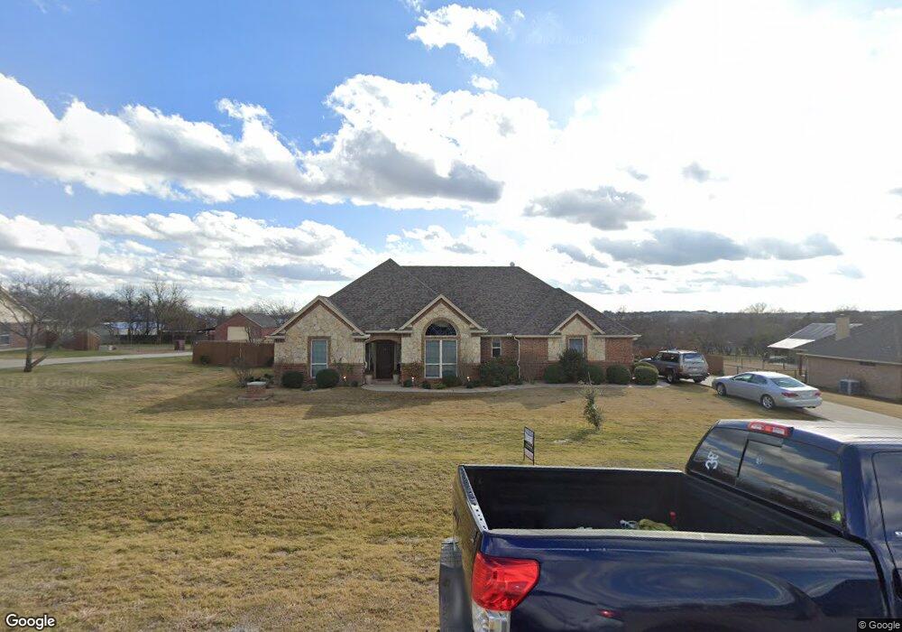
141 Star Point Ln Unit LANE Weatherford, TX 76088
Estimated Value: $474,064 - $535,000
--
Bed
2
Baths
2,206
Sq Ft
$228/Sq Ft
Est. Value
About This Home
This home is located at 141 Star Point Ln Unit LANE, Weatherford, TX 76088 and is currently estimated at $504,016, approximately $228 per square foot. 141 Star Point Ln Unit LANE is a home located in Parker County with nearby schools including Peaster Elementary School, Peaster Middle School, and Peaster High School.
Ownership History
Date
Name
Owned For
Owner Type
Purchase Details
Closed on
Jan 11, 2024
Sold by
Leppert Michelle L and Leppert Ruben B
Bought by
Murphey Patrick John and Murphey Richard John
Current Estimated Value
Home Financials for this Owner
Home Financials are based on the most recent Mortgage that was taken out on this home.
Original Mortgage
$400,000
Outstanding Balance
$392,739
Interest Rate
7.03%
Mortgage Type
New Conventional
Estimated Equity
$111,277
Purchase Details
Closed on
May 31, 2017
Sold by
Pinkston Kevin D and Pinkston Leslin C
Bought by
Burns Michael
Home Financials for this Owner
Home Financials are based on the most recent Mortgage that was taken out on this home.
Original Mortgage
$255,290
Interest Rate
4.62%
Mortgage Type
FHA
Purchase Details
Closed on
Sep 25, 2006
Sold by
Finch Paul and Finch Danielle
Bought by
Pinkston Kevin D and Pinkston Leslie C
Home Financials for this Owner
Home Financials are based on the most recent Mortgage that was taken out on this home.
Original Mortgage
$31,400
Interest Rate
6.47%
Mortgage Type
Stand Alone Second
Create a Home Valuation Report for This Property
The Home Valuation Report is an in-depth analysis detailing your home's value as well as a comparison with similar homes in the area
Home Values in the Area
Average Home Value in this Area
Purchase History
| Date | Buyer | Sale Price | Title Company |
|---|---|---|---|
| Murphey Patrick John | -- | None Listed On Document | |
| Burns Michael | $255,290 | None Available | |
| Pinkston Kevin D | -- | Fatco |
Source: Public Records
Mortgage History
| Date | Status | Borrower | Loan Amount |
|---|---|---|---|
| Open | Murphey Patrick John | $400,000 | |
| Previous Owner | Burns Michael | $255,290 | |
| Previous Owner | Pinkston Kevin D | $31,400 | |
| Previous Owner | Pinkston Kevin D | $167,600 |
Source: Public Records
Tax History Compared to Growth
Tax History
| Year | Tax Paid | Tax Assessment Tax Assessment Total Assessment is a certain percentage of the fair market value that is determined by local assessors to be the total taxable value of land and additions on the property. | Land | Improvement |
|---|---|---|---|---|
| 2025 | $6,806 | $482,950 | $70,000 | $412,950 |
| 2024 | $6,806 | $393,120 | $54,000 | $339,120 |
| 2023 | $6,806 | $393,120 | $54,000 | $339,120 |
| 2022 | $6,491 | $325,450 | $45,000 | $280,450 |
| 2021 | $6,542 | $325,450 | $45,000 | $280,450 |
| 2020 | $6,075 | $296,210 | $45,000 | $251,210 |
| 2019 | $6,169 | $286,310 | $45,000 | $241,310 |
| 2018 | $5,253 | $243,040 | $45,000 | $198,040 |
| 2017 | $5,227 | $243,040 | $45,000 | $198,040 |
| 2016 | $4,641 | $215,780 | $23,000 | $192,780 |
| 2015 | $4,577 | $215,780 | $23,000 | $192,780 |
| 2014 | -- | $197,750 | $23,000 | $174,750 |
Source: Public Records
Map
Nearby Homes
- 153 Star Point Ln
- 3400 Fm 920
- 105 N Ridge Ct
- 199 Graystone Dr
- 2912 Fm 920
- 1097 Woodland Rd
- 2001 Woodland Rd
- 1053 Woodland Rd
- 1045 Woodland Rd
- 1049 Woodland Rd
- 1037 Woodland Rd
- 2050 Woodland Rd
- 2055 Woodland Rd
- 2046 Woodland Rd
- 1025 Woodland Rd
- 1044 Woodland Rd
- 1057 Woodland Rd
- 2026 Woodland Rd
- 1029 Woodland Rd
- 2058 Woodland Rd
- 141 Star Point Ln
- 145 Star Point Ln
- 137 Star Point Ln
- Lot 7A Star Point Ln
- Lot 7A Star Point Ln
- Lot 7A Star Point Ln
- 140 Star Point Ln
- 144 Star Point Ln
- 110 Crossing Point Dr
- 133 Star Point Ln
- 149 Star Point Ln
- 132 Noahs Ct
- 130 Star Point Ln
- 148 Star Point Ln
- 3026 Sunrise Trail
- 3028 Sunrise Trail
- 3024 Sunrise Trail
- 129 Star Point Ln
- 3030 Sunrise Trail
- 152 Star Point Ln