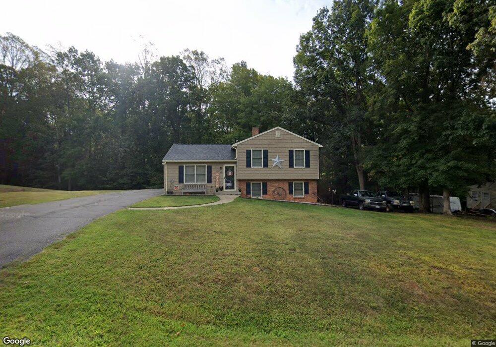
141 Woodrow Ct Monroe, VA 24574
Estimated Value: $217,491 - $270,000
3
Beds
2
Baths
1,061
Sq Ft
$218/Sq Ft
Est. Value
About This Home
This home is located at 141 Woodrow Ct, Monroe, VA 24574 and is currently estimated at $231,123, approximately $217 per square foot. 141 Woodrow Ct is a home located in Amherst County with nearby schools including Amelon Elementary School, Monelison Middle School, and Amherst County High School.
Ownership History
Date
Name
Owned For
Owner Type
Purchase Details
Closed on
Aug 30, 2021
Sold by
Mays Tonya L Pugh and Pugh Tonya L
Bought by
Butt Zachary
Current Estimated Value
Home Financials for this Owner
Home Financials are based on the most recent Mortgage that was taken out on this home.
Original Mortgage
$175,757
Outstanding Balance
$159,926
Interest Rate
2.8%
Mortgage Type
New Conventional
Estimated Equity
$71,197
Create a Home Valuation Report for This Property
The Home Valuation Report is an in-depth analysis detailing your home's value as well as a comparison with similar homes in the area
Home Values in the Area
Average Home Value in this Area
Purchase History
| Date | Buyer | Sale Price | Title Company |
|---|---|---|---|
| Butt Zachary | $174,000 | Sage Title Group Llc |
Source: Public Records
Mortgage History
| Date | Status | Borrower | Loan Amount |
|---|---|---|---|
| Open | Butt Zachary | $175,757 |
Source: Public Records
Tax History Compared to Growth
Tax History
| Year | Tax Paid | Tax Assessment Tax Assessment Total Assessment is a certain percentage of the fair market value that is determined by local assessors to be the total taxable value of land and additions on the property. | Land | Improvement |
|---|---|---|---|---|
| 2025 | $704 | $115,400 | $20,000 | $95,400 |
| 2024 | $704 | $115,400 | $20,000 | $95,400 |
| 2023 | $704 | $115,400 | $20,000 | $95,400 |
| 2022 | $704 | $115,400 | $20,000 | $95,400 |
| 2021 | $704 | $115,400 | $20,000 | $95,400 |
| 2020 | $704 | $115,400 | $20,000 | $95,400 |
| 2019 | $699 | $114,600 | $26,000 | $88,600 |
| 2018 | $699 | $114,600 | $26,000 | $88,600 |
| 2017 | $699 | $114,600 | $26,000 | $88,600 |
| 2016 | $699 | $114,600 | $26,000 | $88,600 |
| 2015 | $642 | $114,600 | $26,000 | $88,600 |
| 2014 | $642 | $114,600 | $26,000 | $88,600 |
Source: Public Records
Map
Nearby Homes
- 379 Winesap Rd
- 0 McIvor Ln
- 0 S Amherst Hwy Unit 360067
- 0 S Amherst Hwy Unit 362100
- 0 S Amherst Hwy Unit 336267
- 124-138 Cedar Gate Rd
- S Amherst Hwy
- 157 Old Country Rd
- 51 Patrick Ct
- 505 Royal Gardens Ct
- 561 Oak Grove Dr
- 272 Dixie Airport Rd
- 139 Grimes Dr
- 150 Glenwood Dr
- 327 Dixie Airport Rd
- 621 Cedar Gate Rd
- 687 Elon Rd
- 115 Morgan Rd
- 138 Magnolia Ln
- 4123 S Amherst Hwy
- 140 Woodrow Ct
- 129 Woodrow Ct
- 149 Woodrow Ct
- 101 Woodrow Ct
- 150 Woodrow Ct
- 128 Woodrow Ct
- 156 Woodrow Ct
- 159 Woodrow Ct
- 161 Woodrow Ct
- 160 Woodrow Ct
- 0 Woodrow Ct
- 118 Woodrow Ct
- 175 Woodrow Ave
- 183 Woodrow Ave
- 169 Woodrow Ave
- 205 Woodrow Ave
- 136 Virginia Dr
- 152 Woodrow Ave
- 118 Virginia Dr
- 148 Woodrow Ave