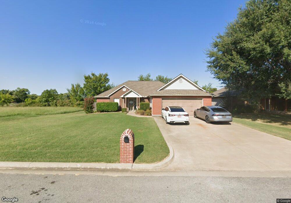
1410 Carter Ave Wagoner, OK 74467
Estimated Value: $205,000 - $262,000
3
Beds
2
Baths
1,581
Sq Ft
$147/Sq Ft
Est. Value
About This Home
This home is located at 1410 Carter Ave, Wagoner, OK 74467 and is currently estimated at $232,486, approximately $147 per square foot. 1410 Carter Ave is a home located in Wagoner County with nearby schools including Ellington Elementary School, William R. Teague Elementary School, and Wagoner Middle School.
Ownership History
Date
Name
Owned For
Owner Type
Purchase Details
Closed on
Nov 13, 2017
Sold by
Ary Drew and Ary Trish
Bought by
Fourkiller Rodney and Fourkiller Amanda
Current Estimated Value
Purchase Details
Closed on
Feb 13, 2006
Sold by
Byrd Darrell R and Byrd Gayle H
Bought by
Fourkiller Rodney A and Fourkiller Amanda Lee
Home Financials for this Owner
Home Financials are based on the most recent Mortgage that was taken out on this home.
Original Mortgage
$132,914
Interest Rate
6.15%
Mortgage Type
FHA
Purchase Details
Closed on
Apr 28, 2004
Sold by
Wofford Investments Inc
Bought by
Byrd Family Revocable Trust
Purchase Details
Closed on
Oct 21, 1994
Sold by
Wagoner Lumber and Ace Hardware
Purchase Details
Closed on
Sep 24, 1990
Create a Home Valuation Report for This Property
The Home Valuation Report is an in-depth analysis detailing your home's value as well as a comparison with similar homes in the area
Home Values in the Area
Average Home Value in this Area
Purchase History
We collect this data history from publicly available records. To have your information removed, we recommend requesting removal directly through your county’s website.
| Date | Buyer | Sale Price | Title Company |
|---|---|---|---|
| Fourkiller Rodney | $92,000 | -- | |
| Fourkiller Rodney A | $135,000 | Multiple | |
| Byrd Family Revocable Trust | $11,000 | American Title Insurance Com | |
| -- | -- | -- | |
| -- | -- | -- |
Source: Public Records
Mortgage History
We collect this data history from publicly available records. To have your information removed, we recommend requesting removal directly through your county’s website.
| Date | Status | Borrower | Loan Amount |
|---|---|---|---|
| Previous Owner | Fourkiller Rodney A | $132,914 |
Source: Public Records
Tax History
| Year | Tax Paid | Tax Assessment Tax Assessment Total Assessment is a certain percentage of the fair market value that is determined by local assessors to be the total taxable value of land and additions on the property. | Land | Improvement |
|---|---|---|---|---|
| 2025 | $1,654 | $19,176 | $1,405 | $17,771 |
| 2024 | $1,627 | $18,618 | $1,364 | $17,254 |
| 2023 | $1,577 | $18,075 | $1,209 | $16,866 |
| 2022 | $1,525 | $17,549 | $1,063 | $16,486 |
| 2021 | $1,485 | $17,038 | $907 | $16,131 |
| 2020 | $1,474 | $16,542 | $907 | $15,635 |
| 2019 | $1,230 | $16,060 | $907 | $15,153 |
| 2018 | $1,302 | $16,060 | $907 | $15,153 |
| 2017 | $1,310 | $16,382 | $907 | $15,475 |
| 2016 | $1,234 | $15,905 | $907 | $14,998 |
| 2015 | $1,211 | $15,442 | $907 | $14,535 |
| 2014 | $1,176 | $14,992 | $1,680 | $13,312 |
Source: Public Records
Map
Nearby Homes
- 27204 E 742 Rd
- 69 S 270 Rd
- 1208 SW 14th Ct
- 1204 SW 12th Place
- 1421 S Hayes Ave
- 0 S Grant Ave
- 0 SW 13th St
- 902 S Lincoln Ave
- 23800 E 720 Rd
- 0 SW 9th St Unit 2537168
- 60 E 740 Rd
- 1807 SW 4th St
- 401 S Hall
- 905 SW 21st St
- 0 SW 4th St
- 1401 S Polk Ave
- 1406 S Filmore Ave
- 1516 W 51 Hwy
- 0 S Taylor Ave
- 0 S Polk Ave
- 1407 Carter Ave
- 1412 Ford Circle Dr
- 1414 Ford Circle Dr
- 1410 Ford Circle Dr
- 1408 Carter Ave
- 1406 Carter Ave
- 1401 Carter Ave
- 1404 Carter Ave
- 1406 Ford Circle Dr
- 1411 Ford Circle Dr
- 1409 Ford Circle Dr
- 1413 Ford Circle Dr
- 1600 SW 15th St
- 1407 Ford Circle Dr
- 1314 Ford Circle Dr
- 1405 Ford Circle Dr
- 1312 Ford Circle Dr
- 1505 Truman St
- 1312 Carter Ave
- 472 Rr 2
Your Personal Tour Guide
Ask me questions while you tour the home.