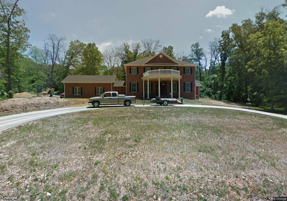
1411 Vine Cassville, MO 65625
Estimated Value: $134,000 - $198,000
3
Beds
2
Baths
1,382
Sq Ft
$124/Sq Ft
Est. Value
About This Home
This home is located at 1411 Vine, Cassville, MO 65625 and is currently estimated at $170,777, approximately $123 per square foot. 1411 Vine is a home with nearby schools including Eunice Thomas Elementary School, Cassville Intermediate School, and Cassville Middle School.
Ownership History
Date
Name
Owned For
Owner Type
Purchase Details
Closed on
May 31, 2024
Sold by
Horner William D and Horner Kim
Bought by
Oliphant Moira
Current Estimated Value
Home Financials for this Owner
Home Financials are based on the most recent Mortgage that was taken out on this home.
Original Mortgage
$118,500
Outstanding Balance
$117,011
Interest Rate
7.1%
Mortgage Type
New Conventional
Estimated Equity
$53,766
Create a Home Valuation Report for This Property
The Home Valuation Report is an in-depth analysis detailing your home's value as well as a comparison with similar homes in the area
Home Values in the Area
Average Home Value in this Area
Purchase History
| Date | Buyer | Sale Price | Title Company |
|---|---|---|---|
| Oliphant Moira | -- | Barry County Abstract & Title |
Source: Public Records
Mortgage History
| Date | Status | Borrower | Loan Amount |
|---|---|---|---|
| Open | Oliphant Moira | $118,500 |
Source: Public Records
Tax History Compared to Growth
Tax History
| Year | Tax Paid | Tax Assessment Tax Assessment Total Assessment is a certain percentage of the fair market value that is determined by local assessors to be the total taxable value of land and additions on the property. | Land | Improvement |
|---|---|---|---|---|
| 2025 | $477 | $11,229 | $2,090 | $9,139 |
| 2024 | $477 | $10,450 | $2,090 | $8,360 |
| 2023 | $477 | $10,450 | $2,090 | $8,360 |
| 2022 | $468 | $10,260 | $1,900 | $8,360 |
| 2021 | $453 | $9,880 | $1,520 | $8,360 |
| 2020 | $453 | $9,880 | $1,520 | $8,360 |
| 2018 | $442 | $9,880 | $1,520 | $8,360 |
| 2017 | $433 | $9,690 | $1,330 | $8,360 |
| 2016 | $380 | $8,398 | $1,330 | $7,068 |
| 2015 | -- | $8,398 | $1,330 | $7,068 |
| 2014 | -- | $8,398 | $1,330 | $7,068 |
| 2012 | -- | $0 | $0 | $0 |
Source: Public Records
Map
Nearby Homes
- 19295 Hillcrest Ln
- 16329 State Highway 76
- 20302 Farm Road 1120
- Lot 4 State Highway 112
- Lot 2 State Highway 112
- Lot 3 State Highway 112
- Lot 1 State Highway 112
- 18008 State Highway 76
- 12655 Farm Road 2205 Cir
- 83 Main St
- 75 Sycamore Dr
- Tbd State Highway 76
- 000 State Highway 86
- 13580 State Highway Aa
- 34 Sunset St
- 106 Mountain St
- 000 S Highway 37
- 000 Townsend West 9th
- 1112 Harold St
- 13992 Farm Road 2185
- 19138 State Highway 112
- 19147 Missouri 112
- 19081 Farm Road 1120
- 19080 State Highway 112
- 19187 State Highway 112
- 19147 State Highway 112
- 19342 Hillcrest Ln
- 19342 Farm Road 1120
- 19226 State Highway 112
- 19211 State Highway 112
- 19320 Hillcrest Ln
- 19325 Hillcrest Ln
- 19304 Hillcrest Ln
- 19057 State Hwy 112
- 19177 Farm Road 1120
- 19283 Hillcrest Ln
- 0 Hwy 112 Unit 606339
- 0 Hwy 112 Unit 637099
- 19242 Hillcrest Ln
- 19249 Hillcrest Ln