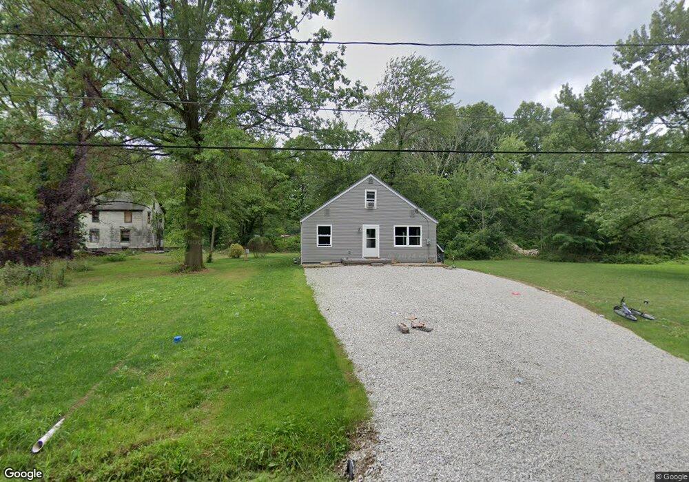
14112 Violet Blvd Alliance, OH 44601
Estimated Value: $123,000 - $153,000
4
Beds
1
Bath
1,712
Sq Ft
$80/Sq Ft
Est. Value
About This Home
This home is located at 14112 Violet Blvd, Alliance, OH 44601 and is currently estimated at $137,014, approximately $80 per square foot. 14112 Violet Blvd is a home located in Mahoning County with nearby schools including Alliance Intermediate School at Northside, Alliance Elementary School at Rockhill, and Alliance Middle School.
Ownership History
Date
Name
Owned For
Owner Type
Purchase Details
Closed on
Feb 16, 2022
Bought by
Accurate Rentals Llc
Current Estimated Value
Purchase Details
Closed on
Feb 11, 2022
Sold by
Koehn Samuel
Bought by
Accurate Rentals Llc
Purchase Details
Closed on
Oct 7, 2020
Bought by
Samuel Koehn
Home Financials for this Owner
Home Financials are based on the most recent Mortgage that was taken out on this home.
Interest Rate
2.88%
Purchase Details
Closed on
Oct 22, 2019
Bought by
Higgins Becky L
Home Financials for this Owner
Home Financials are based on the most recent Mortgage that was taken out on this home.
Interest Rate
3.69%
Purchase Details
Closed on
Aug 16, 1961
Bought by
Williams Donald D
Create a Home Valuation Report for This Property
The Home Valuation Report is an in-depth analysis detailing your home's value as well as a comparison with similar homes in the area
Home Values in the Area
Average Home Value in this Area
Purchase History
| Date | Buyer | Sale Price | Title Company |
|---|---|---|---|
| Accurate Rentals Llc | -- | -- | |
| Accurate Rentals Llc | -- | None Listed On Document | |
| Accurate Rentals Llc | -- | None Listed On Document | |
| Samuel Koehn | $15,000 | -- | |
| Higgins Becky L | -- | -- | |
| Williams Donald D | -- | -- |
Source: Public Records
Mortgage History
| Date | Status | Borrower | Loan Amount |
|---|---|---|---|
| Previous Owner | Samuel Koehn | -- | |
| Previous Owner | Samuel Koehn | -- |
Source: Public Records
Tax History Compared to Growth
Tax History
| Year | Tax Paid | Tax Assessment Tax Assessment Total Assessment is a certain percentage of the fair market value that is determined by local assessors to be the total taxable value of land and additions on the property. | Land | Improvement |
|---|---|---|---|---|
| 2024 | $1,207 | $29,100 | $770 | $28,330 |
| 2023 | $1,368 | $29,100 | $770 | $28,330 |
| 2022 | $54 | $1,150 | $600 | $550 |
| 2021 | $55 | $1,150 | $600 | $550 |
| 2020 | $57 | $1,150 | $600 | $550 |
| 2019 | $55 | $1,060 | $600 | $460 |
| 2018 | $69 | $1,060 | $600 | $460 |
| 2017 | $254 | $1,060 | $600 | $460 |
| 2016 | $451 | $8,750 | $600 | $8,150 |
| 2015 | $443 | $8,750 | $600 | $8,150 |
| 2014 | $460 | $8,750 | $600 | $8,150 |
| 2013 | $454 | $8,750 | $600 | $8,150 |
Source: Public Records
Map
Nearby Homes
- 22841 Lake Park Blvd
- 1233 Woodland Ave
- 831 Wade Ave
- 814 Milner St
- 1044 S Liberty Ave
- 834 Devine St
- 442 S Liberty Ave
- 815 Grace St
- 729 Waugh St
- 263 Franklin Ave
- 1235 Elm St
- 548 E High St
- 1005 S Freedom Ave
- V/L S Fredeom Ave
- 328 N Webb Ave
- 452 E Summit St
- 432 S Linden Ave
- 404 S Linden Ave
- 652 N Webb Ave
- 1437 S Linden Ave
- 22034 Alden Ave
- 22033 Alden Ave
- 22070 Alden Ave
- 22046 Norman Ave
- 22024 Norman Ave
- 22023 Norman Ave
- 22169 Alden Ave
- 22175 Lake Park Blvd
- 22177 Alden Ave
- 22186 Alden Ave
- 22203 Lake Park Blvd
- 22211 Alden Ave
- 22219 Lake Park Blvd
- 22230 Alden Ave
- 22243 Lake Park Blvd
- 22212 Norman Ave
- 13984 Helen St
- 22070 Harding Dr
- 22260 Alden Ave
- 22241 Alden Ave