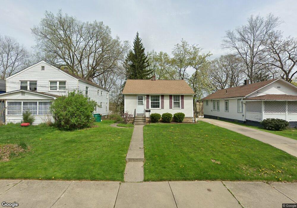
14129 Maple Ave Maple Heights, OH 44137
Estimated Value: $88,556 - $208,000
2
Beds
1
Bath
840
Sq Ft
$145/Sq Ft
Est. Value
About This Home
This home is located at 14129 Maple Ave, Maple Heights, OH 44137 and is currently estimated at $122,139, approximately $145 per square foot. 14129 Maple Ave is a home located in Cuyahoga County with nearby schools including Abraham Lincoln Elementary School, Rockside/ J.F. Kennedy School, and Barack Obama School.
Ownership History
Date
Name
Owned For
Owner Type
Purchase Details
Closed on
Dec 8, 2009
Sold by
Estate Of Albert R Spatney
Bought by
Spatney Frances M
Current Estimated Value
Purchase Details
Closed on
Jan 1, 1975
Bought by
Spatney Albert R and Spatney Frances M
Create a Home Valuation Report for This Property
The Home Valuation Report is an in-depth analysis detailing your home's value as well as a comparison with similar homes in the area
Home Values in the Area
Average Home Value in this Area
Purchase History
| Date | Buyer | Sale Price | Title Company |
|---|---|---|---|
| Spatney Frances M | -- | Attorney | |
| Spatney Albert R | -- | -- |
Source: Public Records
Tax History
| Year | Tax Paid | Tax Assessment Tax Assessment Total Assessment is a certain percentage of the fair market value that is determined by local assessors to be the total taxable value of land and additions on the property. | Land | Improvement |
|---|---|---|---|---|
| 2024 | $1,488 | $24,710 | $9,625 | $15,085 |
| 2023 | $1,111 | $18,310 | $5,080 | $13,230 |
| 2022 | $1,145 | $18,305 | $5,075 | $13,230 |
| 2021 | $1,213 | $18,310 | $5,080 | $13,230 |
| 2020 | $828 | $13,860 | $3,850 | $10,010 |
| 2019 | $815 | $39,600 | $11,000 | $28,600 |
| 2018 | $404 | $13,860 | $3,850 | $10,010 |
| 2017 | $820 | $13,870 | $4,870 | $9,000 |
| 2016 | $787 | $13,870 | $4,870 | $9,000 |
| 2015 | $762 | $13,870 | $4,870 | $9,000 |
| 2014 | $762 | $14,290 | $5,010 | $9,280 |
Source: Public Records
Map
Nearby Homes
- 5220 Forest Ave
- 5179 Milo Ave
- 14305 Granger Rd
- 14510 Granger Rd
- 14512 Granger Rd
- 5270 E 135th St
- 13704 Linn Ave
- 4955 E 141st St
- 14567 Pease Rd
- 5408 Roland Dr
- 13719 Wolf Ave
- 5365 E 131st St
- 15095 Granger Rd
- 5353 E 129th St
- 13008 Willard Ave
- 12516 Park Knoll Dr
- 12328 Granger Rd
- 13009 Oak Park Blvd
- 13116 Oak Park Blvd
- 4754 Lawrence Ave
- 14147 Maple Ave
- 14113 Maple Ave
- 14149 Maple Ave
- 14071 Maple Ave
- 14039 Maple Ave
- 14009 Maple Ave
- 5197 Milo Ave
- 5190 Forest Ave
- 5201 Milo Ave
- 5198 Forest Ave
- 5205 Milo Ave
- 5202 Forest Ave
- 14010 Maple Ave
- 5209 Milo Ave
- 5206 Forest Ave
- 5211 Milo Ave
- 5196 Milo Ave
- 14275 Maple Ave
- 5216 Milo Ave
- 5221 Milo Ave