
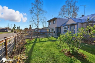


1414 Airport Heights Dr Anchorage, AK 99508
Airport Heights NeighborhoodEstimated payment $2,773/month
Highlights
- Private Yard
- Views
- Baseboard Heating
- Den
- Shed
- Family Room
About This Home
Income potential property in Airport Heights! Home is currently used as a SF w/Additional living space w/ separate entry; add a small wall and have a third rentable unit. Large fenced front and back yard with alley access from the back. Two double gates on both sides for additional toy parking along with large gravel pad off road. Newer windows, new flooring and updates throughout over the year

Home Details
Home Type
- Single Family
Est. Annual Taxes
- $6,161
Year Built
- Built in 1948
Lot Details
- 9,583 Sq Ft Lot
- Fenced
- Private Yard
- Suitable for Bed and Breakfast
- Property is zoned R2D, Two Family Residential
Home Design
- Pillar, Post or Pier Foundation
- Built-Up Roof
- Bitumen Roof
- Metal Roof
Interior Spaces
- 1,765 Sq Ft Home
- Family Room
- Den
- Laminate Flooring
- Property Views
Bedrooms and Bathrooms
- 4 Bedrooms
- 3 Full Bathrooms
Schools
- Airport Heights Elementary School
- Wendler Middle School
- Bettye Davis East Anchorage High School
Additional Features
- Shed
- Baseboard Heating
Map
Home Values in the Area
Average Home Value in this Area
Tax History
| Year | Tax Paid | Tax Assessment Tax Assessment Total Assessment is a certain percentage of the fair market value that is determined by local assessors to be the total taxable value of land and additions on the property. | Land | Improvement |
|---|---|---|---|---|
| 2025 | $2,528 | $404,600 | $106,600 | $298,000 |
| 2024 | $2,528 | $381,600 | $106,600 | $275,000 |
| 2023 | $5,850 | $343,500 | $106,600 | $236,900 |
| 2022 | $4,976 | $345,500 | $106,600 | $238,900 |
| 2021 | $5,523 | $306,500 | $106,600 | $199,900 |
| 2020 | $4,437 | $311,300 | $106,600 | $204,700 |
| 2019 | $4,173 | $305,100 | $106,600 | $198,500 |
| 2018 | $4,184 | $305,100 | $106,600 | $198,500 |
| 2017 | $4,513 | $308,200 | $106,600 | $201,600 |
| 2016 | $3,855 | $292,700 | $89,600 | $203,100 |
| 2015 | $3,855 | $288,400 | $89,600 | $198,800 |
| 2014 | $3,855 | $284,700 | $82,500 | $202,200 |
Property History
| Date | Event | Price | List to Sale | Price per Sq Ft |
|---|---|---|---|---|
| 12/17/2025 12/17/25 | Pending | -- | -- | -- |
| 12/08/2025 12/08/25 | Price Changed | $430,000 | -4.4% | $244 / Sq Ft |
| 10/22/2025 10/22/25 | For Sale | $450,000 | -- | $255 / Sq Ft |
Purchase History
| Date | Type | Sale Price | Title Company |
|---|---|---|---|
| Warranty Deed | -- | -- |
Mortgage History
| Date | Status | Loan Amount | Loan Type |
|---|---|---|---|
| Open | $155,200 | Purchase Money Mortgage |
Source: Alaska Multiple Listing Service
MLS Number: 25-13372
APN: 00411306000
Disclaimer: Certain information contained herein is derived from information provided by parties other than Homes.com. All information provided is deemed reliable, but is not guaranteed to be accurate and should be independently verified.
![]() The listing content relating to real estate for sale on this web site comes in part from the IDX Program of Alaska Multiple Listing Service, Inc. (AK MLS). Real estate listings held by brokerage firms other than Ten-X are marked with either the listing brokerage’s logo or the AK MLS logo and information about them includes the name of the listing brokerage. All information is deemed reliable but is not guaranteed and should be independently verified for accuracy. Copyright 2025 Alaska Multiple Listing Service, Inc. All rights reserved.
The listing content relating to real estate for sale on this web site comes in part from the IDX Program of Alaska Multiple Listing Service, Inc. (AK MLS). Real estate listings held by brokerage firms other than Ten-X are marked with either the listing brokerage’s logo or the AK MLS logo and information about them includes the name of the listing brokerage. All information is deemed reliable but is not guaranteed and should be independently verified for accuracy. Copyright 2025 Alaska Multiple Listing Service, Inc. All rights reserved.
- 1430 Columbine St
- 3401 E 15th Ave
- 1701 Aleutian St
- 1811 Talkeetna St
- 2215 Sunburst Cir
- 1760 Eastridge Dr
- 000 Tr A Thurston
- 1833 Parkside Dr
- 3964 Reka Dr Unit D3
- 1625 Sitka St Unit 103
- 4011 San Roberto Ave
- 4075 E 20th Ave Unit B44
- 611 Bragaw St
- 1803 Parkside Dr
- 2068 Cliffside Dr Unit 11
- 550 Bragaw St
- 2553 Lovejoy Dr
- 4026 E 6th Ave
- 4333 San Ernesto Ave Unit 207A
- 4330 San Roberto Ave