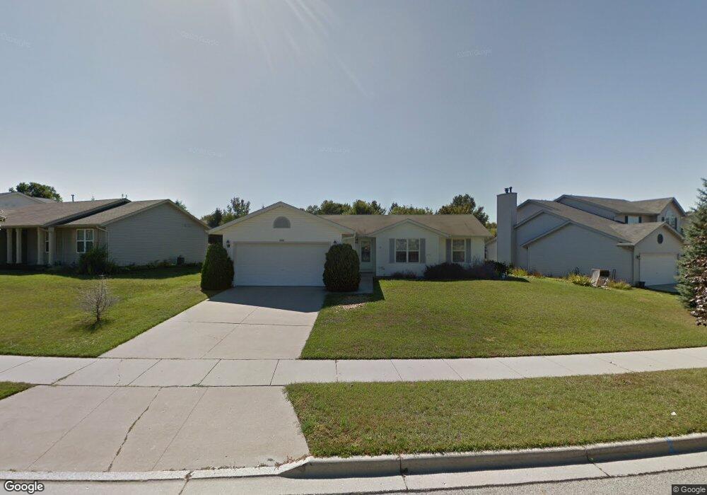
1414 Ravine Forest Dr West Bend, WI 53090
Estimated Value: $351,483 - $420,000
3
Beds
2
Baths
1,248
Sq Ft
$305/Sq Ft
Est. Value
About This Home
This home is located at 1414 Ravine Forest Dr, West Bend, WI 53090 and is currently estimated at $381,121, approximately $305 per square foot. 1414 Ravine Forest Dr is a home located in Washington County with nearby schools including Green Tree Elementary School, Silverbrook Intermediate School, and East High School.
Ownership History
Date
Name
Owned For
Owner Type
Purchase Details
Closed on
May 22, 2015
Sold by
Kent Darlene
Bought by
Grigg Jonathon and Grigg Chantel
Current Estimated Value
Purchase Details
Closed on
May 20, 2005
Sold by
Curry David and Curry Judith
Bought by
Kent Timothy and Kent Darlene
Home Financials for this Owner
Home Financials are based on the most recent Mortgage that was taken out on this home.
Original Mortgage
$152,000
Interest Rate
6.54%
Mortgage Type
Assumption
Purchase Details
Closed on
Feb 14, 2005
Sold by
Secretary Of Hud
Bought by
Curry David and Curry Judith
Home Financials for this Owner
Home Financials are based on the most recent Mortgage that was taken out on this home.
Original Mortgage
$61,917
Interest Rate
5.71%
Mortgage Type
Purchase Money Mortgage
Create a Home Valuation Report for This Property
The Home Valuation Report is an in-depth analysis detailing your home's value as well as a comparison with similar homes in the area
Home Values in the Area
Average Home Value in this Area
Purchase History
| Date | Buyer | Sale Price | Title Company |
|---|---|---|---|
| Grigg Jonathon | $180,000 | -- | |
| Kent Timothy | $190,000 | None Available | |
| Curry David | -- | None Available |
Source: Public Records
Mortgage History
| Date | Status | Borrower | Loan Amount |
|---|---|---|---|
| Previous Owner | Kent Timothy | $152,000 | |
| Previous Owner | Curry David | $61,917 |
Source: Public Records
Tax History Compared to Growth
Tax History
| Year | Tax Paid | Tax Assessment Tax Assessment Total Assessment is a certain percentage of the fair market value that is determined by local assessors to be the total taxable value of land and additions on the property. | Land | Improvement |
|---|---|---|---|---|
| 2024 | $3,712 | $289,600 | $49,600 | $240,000 |
| 2023 | $3,399 | $189,400 | $46,200 | $143,200 |
| 2022 | $3,267 | $189,400 | $46,200 | $143,200 |
| 2021 | $3,345 | $189,400 | $46,200 | $143,200 |
| 2020 | $3,182 | $182,700 | $46,200 | $136,500 |
| 2019 | $3,072 | $182,700 | $46,200 | $136,500 |
| 2018 | $2,986 | $182,700 | $46,200 | $136,500 |
| 2017 | $2,998 | $163,800 | $46,200 | $117,600 |
| 2016 | $3,013 | $163,800 | $46,200 | $117,600 |
| 2015 | $3,100 | $163,800 | $46,200 | $117,600 |
| 2014 | $3,100 | $163,800 | $46,200 | $117,600 |
| 2013 | $3,351 | $163,800 | $46,200 | $117,600 |
Source: Public Records
Map
Nearby Homes
- 2702 Great Forest Dr
- 1661 Great Forest Dr
- 3218 Windsor Place
- 810 Rockingham Ct Unit D
- 2124 Willowbrook Dr
- 2110 Hollow Cir
- 2028 Cardinal Dr
- 3404 Caleb Ct
- Lt5 Schuster Dr
- Lt3 Schuster Dr
- Lt4 Schuster Dr
- Lt3-5 Schuster Dr
- 1208 N Glenwood Cir
- 2346 W Washington St
- 4000 W Washington St
- 602 Shepherds Dr Unit 5
- Lt1 Dandelion Ln
- 1521 Quietwood Ln
- 125 N University Dr Unit 220
- 151 N University Dr Unit 111
- 1418 Ravine Forest Dr
- 1406 Ravine Forest Dr
- 2712 Hidden Forest Place
- 1422 Ravine Forest Dr
- 1400 Ravine Forest Dr
- 1426 Ravine Forest Dr
- 2716 Hidden Forest Place
- 1413 Ravine Forest Dr
- 1409 Ravine Forest Dr
- 1417 Ravine Forest Dr
- 2629 Upper Forest Ln
- 1405 Ravine Forest Dr
- 1500 Ravine Forest Dr
- 2624 Park Forest Dr
- 2703 Hidden Forest Place
- 2720 Hidden Forest Place
- 2625 Upper Forest Ln
- 1504 Ravine Forest Dr
- 1428 Lower Forest Ct
- 1420 Lower Forest Ct