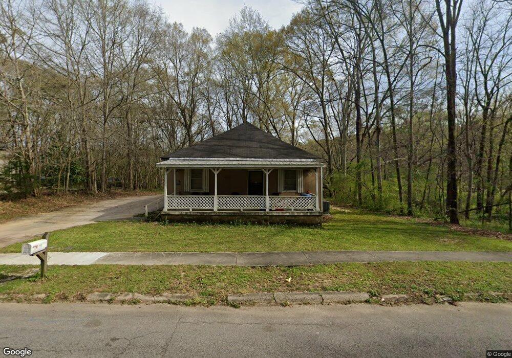
1415 Forrest Ave Lagrange, GA 30240
Estimated Value: $111,000 - $193,000
3
Beds
1
Bath
1,504
Sq Ft
$96/Sq Ft
Est. Value
About This Home
This home is located at 1415 Forrest Ave, Lagrange, GA 30240 and is currently estimated at $144,593, approximately $96 per square foot. 1415 Forrest Ave is a home located in Troup County with nearby schools including Berta Weathersbee Elementary School, Whitesville Road Elementary School, and Rosemont Elementary School.
Ownership History
Date
Name
Owned For
Owner Type
Purchase Details
Closed on
May 24, 2002
Sold by
Equicredit Corp Of Ga
Bought by
Edelson Stephen
Current Estimated Value
Purchase Details
Closed on
Mar 8, 2001
Sold by
Cameron Patricia
Bought by
Equicredit Corp Of Ga
Purchase Details
Closed on
Oct 18, 1999
Sold by
Lamar Mckeen D
Bought by
Cameron Patricia
Purchase Details
Closed on
Apr 12, 1988
Bought by
Lamar Mckeen D
Purchase Details
Closed on
Dec 1, 1981
Purchase Details
Closed on
Nov 14, 1980
Purchase Details
Closed on
Jan 1, 1953
Create a Home Valuation Report for This Property
The Home Valuation Report is an in-depth analysis detailing your home's value as well as a comparison with similar homes in the area
Purchase History
| Date | Buyer | Sale Price | Title Company |
|---|---|---|---|
| Edelson Stephen | $17,900 | -- | |
| Equicredit Corp Of Ga | -- | -- | |
| Cameron Patricia | $50,000 | -- | |
| Lamar Mckeen D | $12,000 | -- | |
| -- | -- | -- | |
| -- | -- | -- | |
| -- | -- | -- |
Source: Public Records
Tax History Compared to Growth
Tax History
| Year | Tax Paid | Tax Assessment Tax Assessment Total Assessment is a certain percentage of the fair market value that is determined by local assessors to be the total taxable value of land and additions on the property. | Land | Improvement |
|---|---|---|---|---|
| 2025 | $763 | $28,400 | $4,040 | $24,360 |
| 2024 | $763 | $27,960 | $2,000 | $25,960 |
| 2023 | $703 | $25,760 | $2,000 | $23,760 |
| 2022 | $653 | $23,400 | $2,000 | $21,400 |
| 2021 | $554 | $18,360 | $2,000 | $16,360 |
| 2020 | $554 | $18,360 | $2,000 | $16,360 |
| 2019 | $520 | $17,240 | $2,000 | $15,240 |
| 2018 | $527 | $17,484 | $2,044 | $15,440 |
| 2017 | $527 | $17,484 | $2,044 | $15,440 |
| 2016 | $521 | $17,290 | $2,044 | $15,246 |
| 2015 | $522 | $17,290 | $2,044 | $15,246 |
| 2014 | $499 | $16,488 | $2,044 | $14,444 |
| 2013 | -- | $17,217 | $2,044 | $15,173 |
Source: Public Records
Map
Nearby Homes
- 1808 Murphy Ave
- 900 B N Pkwy
- 1308 Park Ave
- 1304 Forrest Ave
- 1402 Forrest Ave
- 1311 Juniper St
- 1302 Murphy Ave
- 1300 Murphy Ave
- 1301 Polk St
- 205 Grady St
- 701 Jefferson St
- 606 Poplar St
- 1518 Brownwood Ave
- 812 Elm St
- 109 Garfield St
- 612 S Lee St
- 133 Garfield St
- The Rhodes Plan at Crown Street Cottages
- The Truitt Plan at Crown Street Cottages
- The Callaway Plan at Crown Street Cottages
- 1413 Forrest Ave
- 1411 Forrest Ave
- 1417 Forrest Ave
- 1408 Forrest Ave
- 1409 Forrest Ave
- 1406 Forrest Ave
- 1419 Forrest Ave
- 1407 Forrest Ave
- 1424 Forrest Ave
- 1424 Forrest Ave Unit 1
- 1231 Troup St
- 1229 Troup St
- 1227 Troup St
- 1403 Forrest Ave
- 1400 Forrest Ave
- 1225 Troup St
- 1326 Washington St
- 1706 Adamson St
- 1704 Adamson St
- 1708 Adamson St