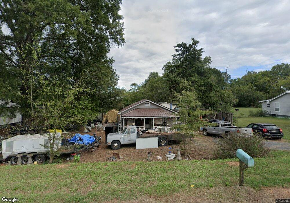
1415 Us 41 N Calhoun, GA 30701
Estimated Value: $158,706 - $221,000
3
Beds
2
Baths
1,157
Sq Ft
$167/Sq Ft
Est. Value
About This Home
This home is located at 1415 Us 41 N, Calhoun, GA 30701 and is currently estimated at $193,569, approximately $167 per square foot. 1415 Us 41 N is a home located in Gordon County with nearby schools including Tolbert Elementary School, Ashworth Middle School, and Gordon Central High School.
Ownership History
Date
Name
Owned For
Owner Type
Purchase Details
Closed on
Jun 15, 2010
Sold by
Turner Linda M
Bought by
Cheek Melvin and Cheek Brenda
Current Estimated Value
Purchase Details
Closed on
Jun 2, 2009
Sold by
Vineyard Kevin
Bought by
Copeland Arla
Purchase Details
Closed on
May 10, 2001
Sold by
Copeland Arla D
Bought by
Vineyard Kevin and Vineyard Diane
Purchase Details
Closed on
May 1, 2001
Sold by
Kennedy Daniel and Christi Kenne
Bought by
Copeland Arla D
Purchase Details
Closed on
Dec 28, 2000
Sold by
Copeland Arla D
Bought by
Kennedy Daniel and Christi Kennedy
Purchase Details
Closed on
Jul 11, 1997
Bought by
Copeland Arla D
Purchase Details
Closed on
Jan 10, 1994
Bought by
Simpson Stanley
Create a Home Valuation Report for This Property
The Home Valuation Report is an in-depth analysis detailing your home's value as well as a comparison with similar homes in the area
Home Values in the Area
Average Home Value in this Area
Purchase History
| Date | Buyer | Sale Price | Title Company |
|---|---|---|---|
| Cheek Melvin | $37,500 | -- | |
| Cheek Melvin | $37,500 | -- | |
| Copeland Arla | -- | -- | |
| Vineyard Kevin | $52,000 | -- | |
| Copeland Arla D | -- | -- | |
| Kennedy Daniel | $50,000 | -- | |
| Copeland Arla D | -- | -- | |
| Simpson Stanley | $20,000 | -- |
Source: Public Records
Tax History Compared to Growth
Tax History
| Year | Tax Paid | Tax Assessment Tax Assessment Total Assessment is a certain percentage of the fair market value that is determined by local assessors to be the total taxable value of land and additions on the property. | Land | Improvement |
|---|---|---|---|---|
| 2024 | $239 | $28,436 | $3,440 | $24,996 |
| 2023 | $226 | $26,964 | $3,440 | $23,524 |
| 2022 | $223 | $25,452 | $3,440 | $22,012 |
| 2021 | $178 | $20,704 | $3,440 | $17,264 |
| 2020 | $182 | $20,992 | $3,440 | $17,552 |
| 2019 | $183 | $20,992 | $3,440 | $17,552 |
| 2018 | $173 | $19,972 | $3,440 | $16,532 |
| 2017 | $167 | $19,012 | $3,440 | $15,572 |
| 2016 | $505 | $19,012 | $3,440 | $15,572 |
| 2015 | $500 | $18,692 | $3,440 | $15,252 |
| 2014 | $465 | $17,968 | $3,479 | $14,489 |
Source: Public Records
Map
Nearby Homes
- 308 Heritage Dr
- 204 Patriots Row SW
- 0 Woodland Cir NW
- 228 Woodland Cir NW
- 1325 U S 41
- 157 Chance Dr NW
- 357 Soldiers Pathway
- 453 Chatsworth Highway 225 NE
- 103 Mcginnis Cir
- 307 Craigtown Rd NE
- 104 Cornwell Way
- 208 Mcginnis Cir
- 403 S Sequoyah Cir NE
- 516 Mcginnis Cir
- 1215 U S 41
- 00 Mauldin Rd NW
- 000 Mauldin Rd
- 2796 U S 41
- 111 Nike Dr
- Spruce Plan at Riverside at Calhoun