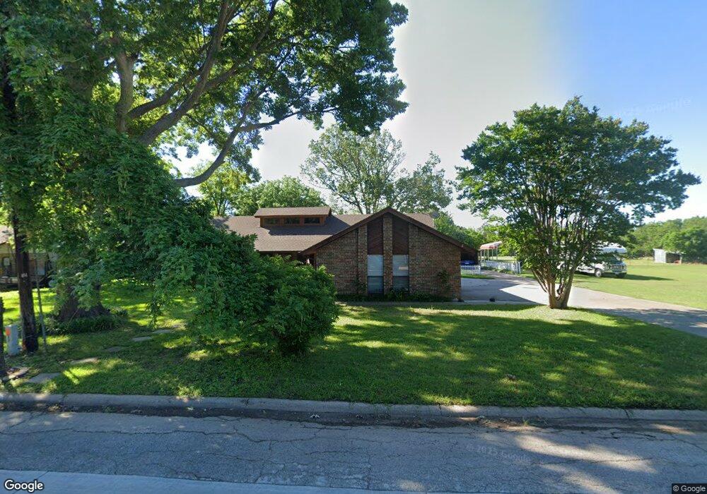
1415 W Lone Star Ave Cleburne, TX 76033
Estimated Value: $250,000 - $328,000
3
Beds
2
Baths
1,873
Sq Ft
$150/Sq Ft
Est. Value
About This Home
This home is located at 1415 W Lone Star Ave, Cleburne, TX 76033 and is currently estimated at $280,795, approximately $149 per square foot. 1415 W Lone Star Ave is a home located in Johnson County with nearby schools including Cooke Elementary School, A.D. Wheat Middle School, and Cleburne High School.
Ownership History
Date
Name
Owned For
Owner Type
Purchase Details
Closed on
Oct 24, 2018
Sold by
Larkins Donna D
Bought by
Browning Raymond Wesley and Browning Lorinda
Current Estimated Value
Home Financials for this Owner
Home Financials are based on the most recent Mortgage that was taken out on this home.
Original Mortgage
$186,558
Outstanding Balance
$168,237
Interest Rate
6.25%
Mortgage Type
FHA
Estimated Equity
$112,558
Create a Home Valuation Report for This Property
The Home Valuation Report is an in-depth analysis detailing your home's value as well as a comparison with similar homes in the area
Home Values in the Area
Average Home Value in this Area
Purchase History
| Date | Buyer | Sale Price | Title Company |
|---|---|---|---|
| Browning Raymond Wesley | -- | None Available |
Source: Public Records
Mortgage History
| Date | Status | Borrower | Loan Amount |
|---|---|---|---|
| Open | Browning Raymond Wesley | $186,558 |
Source: Public Records
Tax History Compared to Growth
Tax History
| Year | Tax Paid | Tax Assessment Tax Assessment Total Assessment is a certain percentage of the fair market value that is determined by local assessors to be the total taxable value of land and additions on the property. | Land | Improvement |
|---|---|---|---|---|
| 2025 | $2,798 | $186,550 | $29,500 | $157,050 |
| 2024 | $4,159 | $186,550 | $29,500 | $157,050 |
| 2023 | $2,805 | $186,550 | $29,500 | $157,050 |
| 2022 | $4,669 | $186,550 | $29,500 | $157,050 |
| 2021 | $4,867 | $186,550 | $29,500 | $157,050 |
| 2020 | $4,906 | $177,050 | $20,000 | $157,050 |
| 2019 | $5,232 | $177,050 | $20,000 | $157,050 |
| 2018 | $4,105 | $138,860 | $20,625 | $118,235 |
| 2017 | $4,088 | $138,860 | $20,625 | $118,235 |
| 2016 | $2,729 | $92,714 | $13,500 | $79,214 |
| 2015 | $1,465 | $92,714 | $13,500 | $79,214 |
| 2014 | $1,465 | $93,861 | $13,500 | $80,361 |
Source: Public Records
Map
Nearby Homes
- 618 Woodard Ave
- 1419 Quail Creek Dr
- Iverson 1 Plan at Trail Creek
- Hanover Plan at Trail Creek
- Devin Plan at Trail Creek
- Newcastle Plan at Trail Creek
- Sherwood Plan at Trail Creek
- Essex Plan at Trail Creek
- Cambria 1 Plan at Trail Creek
- 1102 Holly St
- 1401 Quail Creek Dr
- 1307 Joslin St
- 1102 Lena St
- 1315 Grand Ave
- 1123 Bales St
- 1300 Holly St
- 604 Mcanear St
- 1006 Princeton Place
- 1016 Sheridan Ln
- 902 Turner St
- 1411 W Lone Star Ave
- 1407 W Lone Star Ave
- 1416 W Lone Star Ave
- 622 Woodard Ave
- 1414 W Lone Star Ave
- 1412 W Lone Star Ave
- TBD W Lone Star Ave
- 614 Woodard Ave
- 626 Woodard Ave
- 1013 Grand Ave
- 1410 W Lone Star Ave
- 612 Woodard Ave
- 1009 Grand Ave
- 610 Woodard Ave
- 1007 Grand Ave
- 630 Woodard Ave
- 1101 Grand Ave
- 606 Woodard Ave
- 604 Woodard Ave
- 1313 Poindexter Ave