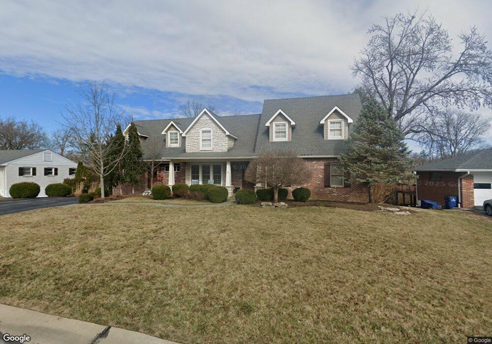
1416 Kendon Dr Saint Louis, MO 63131
Estimated Value: $1,571,000 - $2,340,000
4
Beds
6
Baths
6,593
Sq Ft
$278/Sq Ft
Est. Value
About This Home
This home is located at 1416 Kendon Dr, Saint Louis, MO 63131 and is currently estimated at $1,832,499, approximately $277 per square foot. 1416 Kendon Dr is a home located in St. Louis County with nearby schools including Westchester Elementary School, North Kirkwood Middle School, and Kirkwood Senior High School.
Ownership History
Date
Name
Owned For
Owner Type
Purchase Details
Closed on
Jul 9, 1998
Sold by
Pullen Jeffrey B and Pullen Lynn
Bought by
Janson Gregory L and Janson Jennifer A
Current Estimated Value
Home Financials for this Owner
Home Financials are based on the most recent Mortgage that was taken out on this home.
Original Mortgage
$191,760
Outstanding Balance
$39,550
Interest Rate
7.09%
Mortgage Type
VA
Estimated Equity
$1,792,949
Create a Home Valuation Report for This Property
The Home Valuation Report is an in-depth analysis detailing your home's value as well as a comparison with similar homes in the area
Home Values in the Area
Average Home Value in this Area
Purchase History
| Date | Buyer | Sale Price | Title Company |
|---|---|---|---|
| Janson Gregory L | -- | First American Title |
Source: Public Records
Mortgage History
| Date | Status | Borrower | Loan Amount |
|---|---|---|---|
| Open | Janson Gregory L | $191,760 |
Source: Public Records
Tax History Compared to Growth
Tax History
| Year | Tax Paid | Tax Assessment Tax Assessment Total Assessment is a certain percentage of the fair market value that is determined by local assessors to be the total taxable value of land and additions on the property. | Land | Improvement |
|---|---|---|---|---|
| 2025 | $14,310 | $295,850 | $70,320 | $225,530 |
| 2024 | $14,310 | $248,010 | $52,500 | $195,510 |
| 2023 | $14,088 | $248,010 | $52,500 | $195,510 |
| 2022 | $13,761 | $225,820 | $52,500 | $173,320 |
| 2021 | $13,613 | $225,820 | $52,500 | $173,320 |
| 2020 | $12,318 | $196,420 | $48,450 | $147,970 |
| 2019 | $12,334 | $196,420 | $48,450 | $147,970 |
| 2018 | $11,828 | $169,010 | $27,230 | $141,780 |
| 2017 | $11,860 | $169,010 | $27,230 | $141,780 |
| 2016 | $11,358 | $163,950 | $23,430 | $140,520 |
| 2015 | $11,372 | $163,950 | $23,430 | $140,520 |
| 2014 | $10,391 | $146,370 | $10,600 | $135,770 |
Source: Public Records
Map
Nearby Homes
- 1126 Bopp Rd
- 8 Briarbrook Trail
- 1345 Woodgate Dr
- 723 Oak Valley Dr
- 1728 Folkstone Dr
- 811 Cherry St
- 1741 Pine Hill Dr
- 1090 Kinstern Dr
- 1029 Kinstern Dr
- 11909 Lillian Ave
- 11913 Lillian Ave
- 12006 Montour Dr
- 11358 Manchester Rd
- 1001 Dovergate Dr
- 918 N Ballas Rd
- 12439 Springdale Ln Unit TBB
- 12224 TBB Roger Ln
- The Hawthorne Plan at Ballas Ridge
- The Roclare II Plan at Ballas Ridge
- The Westchester IV Plan at Ballas Ridge
- 1408 Kendon Dr
- 1424 Kendon Dr
- 1400 Kendon Dr
- 1432 Kendon Dr
- 1501 Fawnvalley Dr
- 1509 Fawnvalley Dr
- 1415 Kendon Dr
- 1479 Fawnvalley Dr
- 1515 Fawnvalley Dr
- 1318 Kendon Dr
- 1471 Fawnvalley Dr
- 11915 Hargrove Dr
- 11901 Kendon Dr
- 1327 Kendon Dr
- 11908 Kendon Dr
- 1521 Fawnvalley Dr
- 1463 Fawnvalley Dr
- 11733 Lindemere Dr
- 11923 Hargrove Dr
- 11907 Kendon Dr