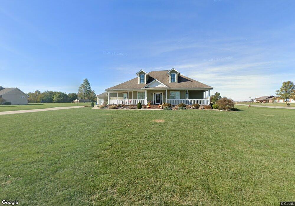
14163 S Fork Aviston, IL 62216
Estimated Value: $503,000 - $769,000
4
Beds
3
Baths
2,144
Sq Ft
$273/Sq Ft
Est. Value
About This Home
This home is located at 14163 S Fork, Aviston, IL 62216 and is currently estimated at $585,373, approximately $273 per square foot. 14163 S Fork is a home with nearby schools including Aviston Elementary School and Central Community High School.
Ownership History
Date
Name
Owned For
Owner Type
Purchase Details
Closed on
Feb 15, 2008
Sold by
Clinton Acres Inc
Bought by
Hilmes Lawrence B and Hilmes Kristi L
Current Estimated Value
Home Financials for this Owner
Home Financials are based on the most recent Mortgage that was taken out on this home.
Original Mortgage
$23,535
Interest Rate
5.75%
Mortgage Type
Purchase Money Mortgage
Create a Home Valuation Report for This Property
The Home Valuation Report is an in-depth analysis detailing your home's value as well as a comparison with similar homes in the area
Home Values in the Area
Average Home Value in this Area
Purchase History
| Date | Buyer | Sale Price | Title Company |
|---|---|---|---|
| Hilmes Lawrence B | $36,500 | None Available |
Source: Public Records
Mortgage History
| Date | Status | Borrower | Loan Amount |
|---|---|---|---|
| Closed | Hilmes Lawrence B | $23,535 |
Source: Public Records
Tax History Compared to Growth
Tax History
| Year | Tax Paid | Tax Assessment Tax Assessment Total Assessment is a certain percentage of the fair market value that is determined by local assessors to be the total taxable value of land and additions on the property. | Land | Improvement |
|---|---|---|---|---|
| 2024 | $8,822 | $152,020 | $19,780 | $132,240 |
| 2023 | $8,822 | $143,410 | $18,660 | $124,750 |
| 2022 | $8,468 | $130,580 | $17,990 | $112,590 |
| 2021 | $7,107 | $124,360 | $17,130 | $107,230 |
| 2020 | $6,631 | $104,860 | $16,470 | $88,390 |
| 2019 | $6,603 | $104,860 | $16,470 | $88,390 |
| 2018 | $6,383 | $97,283 | $12,107 | $85,176 |
| 2017 | $6,229 | $92,650 | $11,530 | $81,120 |
| 2016 | $6,259 | $92,650 | $11,530 | $81,120 |
| 2015 | $5,556 | $92,650 | $11,530 | $81,120 |
| 2013 | $5,556 | $92,100 | $11,530 | $80,570 |
Source: Public Records
Map
Nearby Homes
- 49 Walnut Cir
- 10 S Hull St
- 751 E 4th St
- 3265 Venhaus Rd
- 3221 Venhaus Rd
- 12702 Crestview Ln
- 12746 Rolling Hills Dr
- 630 Wedgewood Ln
- 619 Wedgewood Ln
- 607 Wedgewood Ln
- 525 Wedgewood Ln
- 501 Wedgewood Ln
- 1144 Emily Ln
- 679 Galen Dr
- 437 Galen Dr
- 13636 Alpine Way
- 13613 Alpine Way
- 311 E 3rd St
- 416 N Main St
- 203 S Walnut St
- 14121 S Fork
- 14121 South Fork
- 14231 N Fork
- 14167 S Fork
- 14167 South Fork
- 5079 Sunset Dr
- 5057 Sunset Dr
- 14190 Russland Rd
- 14160 Russland Rd
- 5101 Summercrest
- 14087 S Fork
- 14128 S Fork
- 14128 South Fork
- 5035 Sunset Dr
- 5060 Sunrise Ct
- 5066 Sunrise Ct
- 5120 Sunset Dr
- 5145 Sunset Dr
- 14150 Russland Rd
- 5133 Summercrest