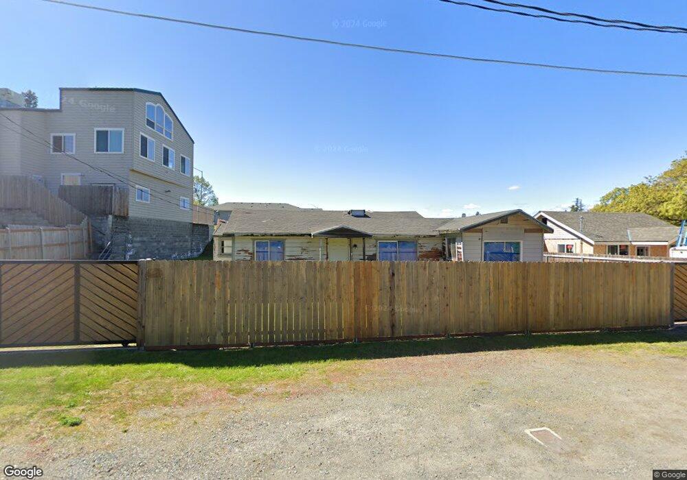
1418 Maple Ln Grants Pass, OR 97527
Estimated Value: $328,764
2
Beds
1
Bath
937
Sq Ft
$351/Sq Ft
Est. Value
About This Home
This home is located at 1418 Maple Ln, Grants Pass, OR 97527 and is currently estimated at $328,764, approximately $350 per square foot. 1418 Maple Ln is a home located in Josephine County with nearby schools including Riverside Elementary School, South Middle School, and Grants Pass High School.
Ownership History
Date
Name
Owned For
Owner Type
Purchase Details
Closed on
Apr 28, 2016
Sold by
Sine Richard and Sine Betty
Bought by
Pollard Michael W
Current Estimated Value
Home Financials for this Owner
Home Financials are based on the most recent Mortgage that was taken out on this home.
Original Mortgage
$245,000
Interest Rate
3.73%
Mortgage Type
Seller Take Back
Purchase Details
Closed on
Apr 13, 2007
Sold by
Sine Richard and Sine Betty
Bought by
Sine Richard and Sine Betty
Create a Home Valuation Report for This Property
The Home Valuation Report is an in-depth analysis detailing your home's value as well as a comparison with similar homes in the area
Home Values in the Area
Average Home Value in this Area
Purchase History
Date | Buyer | Sale Price | Title Company |
---|---|---|---|
Pollard Michael W | $275,000 | Ticor Title Company Of Or | |
Sine Richard | -- | None Available |
Source: Public Records
Mortgage History
Date | Status | Borrower | Loan Amount |
---|---|---|---|
Closed | Pollard Michael W | $245,000 |
Source: Public Records
Tax History Compared to Growth
Tax History
Year | Tax Paid | Tax Assessment Tax Assessment Total Assessment is a certain percentage of the fair market value that is determined by local assessors to be the total taxable value of land and additions on the property. | Land | Improvement |
---|---|---|---|---|
2024 | $3,359 | $251,130 | -- | -- |
2023 | $1,192 | $92,400 | $77,650 | $14,750 |
2022 | $1,182 | $90,780 | $0 | $0 |
2021 | $1,145 | $88,140 | $0 | $0 |
2020 | $1,112 | $85,580 | $0 | $0 |
2019 | $1,080 | $83,090 | $0 | $0 |
2018 | $1,099 | $80,670 | $0 | $0 |
2017 | $1,091 | $78,330 | $0 | $0 |
2016 | $959 | $76,050 | $0 | $0 |
2015 | $884 | $72,600 | $0 | $0 |
2014 | $914 | $73,840 | $0 | $0 |
Source: Public Records
Map
Nearby Homes
- 601 Sunset Way
- 805 Bower Ln
- 271 Fruitdale Dr Unit D
- 1239 Watson Dr
- 1414 Parkdale Dr
- 1679 Virginia Ln
- 299 Reddy St
- 0 Fruitdale Lilac Hilltop Shepha Dr Unit 220196701
- 1696 Parkdale Dr
- 844 Gold Ct
- 122 Parkdale Cir
- 1745 Drury Ln
- 138 Parkdale Cir
- 1757 Parkdale Dr
- 120 SE Gold River Ln
- 204 Redwood Hwy
- 1078 Lee Roze Ln
- 1942 Parkdale Dr
- 115 Gold River Ln
- 1094 Lee Roze Ln
- 1418 Maple Ln
- 688 Rogue River Hwy
- 690 Rogue River Hwy
- 1419 Maple Ln
- 1414 Maple Ln
- 1414 Maple Ln Unit A & B
- 1417 Maple Ln
- 670 Rogue River Hwy
- 1412 Maple Ln
- 1402 Oakhill Ln
- 1410 Oakhill Ln
- 1415 Maple Ln
- 1400 Oakhill Ln
- 670 Fruitdale Dr
- 750 Rogue River Hwy
- 1410 Maple Ln
- 1413 Maple Ln
- 601 Fruitdale Dr
- 660 Rogue River Hwy
- 1411 Maple Ln