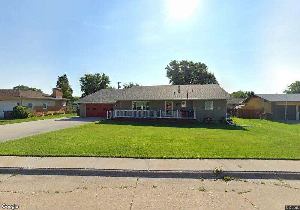
1418 Pershing Rd Hastings, NE 68901
Estimated Value: $350,000 - $509,000
3
Beds
3
Baths
2,376
Sq Ft
$170/Sq Ft
Est. Value
About This Home
This home is located at 1418 Pershing Rd, Hastings, NE 68901 and is currently estimated at $404,594, approximately $170 per square foot. 1418 Pershing Rd is a home located in Adams County with nearby schools including Hastings Senior High School, St. Michael's Preschool & Elementary School, and Zion Lutheran School.
Ownership History
Date
Name
Owned For
Owner Type
Purchase Details
Closed on
Jul 21, 2010
Sold by
Jensen Thomas L and Jensen Marilyn B
Bought by
Spanel Lacritta C
Current Estimated Value
Home Financials for this Owner
Home Financials are based on the most recent Mortgage that was taken out on this home.
Original Mortgage
$110,000
Outstanding Balance
$72,436
Interest Rate
4.54%
Mortgage Type
New Conventional
Estimated Equity
$332,158
Create a Home Valuation Report for This Property
The Home Valuation Report is an in-depth analysis detailing your home's value as well as a comparison with similar homes in the area
Home Values in the Area
Average Home Value in this Area
Purchase History
| Date | Buyer | Sale Price | Title Company |
|---|---|---|---|
| Spanel Lacritta C | $138,000 | Patrick Prairie Title |
Source: Public Records
Mortgage History
| Date | Status | Borrower | Loan Amount |
|---|---|---|---|
| Open | Spanel Lacritta C | $110,000 |
Source: Public Records
Tax History Compared to Growth
Tax History
| Year | Tax Paid | Tax Assessment Tax Assessment Total Assessment is a certain percentage of the fair market value that is determined by local assessors to be the total taxable value of land and additions on the property. | Land | Improvement |
|---|---|---|---|---|
| 2024 | $5,900 | $366,653 | $35,750 | $330,903 |
| 2023 | $6,865 | $332,715 | $35,750 | $296,965 |
| 2022 | $6,373 | $282,940 | $35,750 | $247,190 |
| 2021 | $5,850 | $266,769 | $35,750 | $231,019 |
| 2020 | $5,515 | $255,768 | $35,750 | $220,018 |
| 2019 | $5,109 | $239,470 | $35,750 | $203,720 |
| 2018 | $3,377 | $157,460 | $26,000 | $131,460 |
| 2017 | $3,135 | $155,055 | $0 | $0 |
| 2016 | $2,754 | $128,410 | $26,000 | $102,410 |
| 2011 | -- | $119,000 | $23,400 | $95,600 |
Source: Public Records
Map
Nearby Homes
- 1330 Heritage Dr
- 1223 Westwood Terrace
- 1802 Westchester Dr
- 1201 Pershing Rd
- 1225 Heritage Dr
- 1334 W 12th St
- 1108 N Baltimore Ave
- 1402 Arapahoe Ave
- 1513 Crane Ave
- 1505 Crane Ave
- 1911 W 11th St
- 1314 N Laird Ave
- 1001 N Webster Ave
- 904 N Washington Ave
- 1814 Boyce St
- 1127 N Bellevue Ave
- 1123-1125 N Bellevue Ave
- 1619 Boyce St
- 1011 N Bellevue Ave
- 2330 W 11th St
- 1410 Pershing Rd
- 1500 Pershing Rd
- 1415 Macarthur Rd
- 1425 Macarthur Rd
- 1409 Macarthur Rd
- 1419 Pershing Rd
- 1413 Pershing Rd
- 1710 W 14th St
- 1503 Pershing Rd
- 1401 Pershing Rd
- 1405 Macarthur Rd
- 1706 Imperial Dr
- 1702 Imperial Dr
- 1716 Imperial Dr
- 1726 W 14th St
- 1420 Macarthur Rd
- 1428 Macarthur Rd
- 1622 Imperial Dr
- 1509 Pershing Rd
- 1412 Macarthur Rd