Estimated Value: $743,000 - $886,000
3
Beds
4
Baths
2,733
Sq Ft
$298/Sq Ft
Est. Value
About This Home
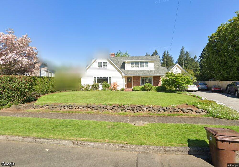
This home is located at 1419 NE 4th Ave, Camas, WA 98607 and is currently estimated at $813,853, approximately $297 per square foot. 1419 NE 4th Ave is a home located in Clark County with nearby schools including Helen Baller Elementary School, Liberty Middle School, and Camas High School.
Ownership History
Date
Name
Owned For
Owner Type
Purchase Details
Closed on
Mar 4, 2025
Sold by
Emerson Peter Maxwell and Emerson Cheryl Lynn
Bought by
Peter M Emerson And Cheryl L Emerson Revocabl and Emerson
Current Estimated Value
Purchase Details
Closed on
Jul 25, 2000
Sold by
Martin John B
Bought by
Emerson Peter Maxwell and Emerson Cheryl Lynn
Home Financials for this Owner
Home Financials are based on the most recent Mortgage that was taken out on this home.
Original Mortgage
$213,400
Interest Rate
8.2%
Create a Home Valuation Report for This Property
The Home Valuation Report is an in-depth analysis detailing your home's value as well as a comparison with similar homes in the area
Home Values in the Area
Average Home Value in this Area
Purchase History
| Date | Buyer | Sale Price | Title Company |
|---|---|---|---|
| Peter M Emerson And Cheryl L Emerson Revocabl | $313 | None Listed On Document | |
| Emerson Peter Maxwell | $220,000 | First American Title Ins Co |
Source: Public Records
Mortgage History
| Date | Status | Borrower | Loan Amount |
|---|---|---|---|
| Previous Owner | Emerson Peter Maxwell | $213,400 |
Source: Public Records
Tax History Compared to Growth
Tax History
| Year | Tax Paid | Tax Assessment Tax Assessment Total Assessment is a certain percentage of the fair market value that is determined by local assessors to be the total taxable value of land and additions on the property. | Land | Improvement |
|---|---|---|---|---|
| 2025 | $6,653 | $640,710 | $120,283 | $520,427 |
| 2024 | $6,347 | $697,984 | $182,830 | $515,154 |
| 2023 | $6,574 | $715,913 | $186,439 | $529,474 |
| 2022 | $6,460 | $705,191 | $179,222 | $525,969 |
| 2021 | $6,055 | $579,212 | $146,745 | $432,467 |
| 2020 | $6,233 | $503,205 | $127,500 | $375,705 |
| 2019 | $5,707 | $480,357 | $120,283 | $360,074 |
| 2018 | $6,757 | $468,486 | $0 | $0 |
| 2017 | $5,450 | $466,238 | $0 | $0 |
| 2016 | $4,984 | $409,523 | $0 | $0 |
| 2015 | $5,025 | $372,641 | $0 | $0 |
| 2014 | -- | $354,239 | $0 | $0 |
| 2013 | -- | $314,952 | $0 | $0 |
Source: Public Records
Map
Nearby Homes
- 924 NE 3rd Ave
- 136 NE Garfield St
- 632 NE Everett St
- 520 NE Province Dr
- 1907 NE Garfield St
- 522 NE Province Dr
- 750 NE Province Ct
- 2193 NE 3rd Ave
- 761 SE Polk St
- 659 SE Russell St
- 940 W Lookout Ridge Dr
- 0 SE Tampa St Unit NWM2442817
- 726 SE Tampa St
- 0 SE Tampa St Unit 650912142
- 0 SE Tampa St Unit 626113580
- 927 W Lookout Ridge Dr
- 753 SE Sumner St
- 1303 Division St
- 835 W U St
- 741 SE Tampa St
- 1435 NE 4th Ave
- 1416 NE 5th Ave
- 1331 NE 4th Ave
- 1346 NE 5th Ave
- 1428 NE 5th Ave
- 1330 NE 5th Ave
- 1317 NE 4th Ave
- 1420 NE 4th Ave
- 1336 NE 4th Ave
- 1507 NE 4th Ave
- 1434 NE 4th Ave
- 1508 NE 5th Ave
- 1320 NE 4th Ave
- 1407 NE 5th Ave
- 1343 NE 5th Ave
- 1248 NE 5th Ave
- 1427 NE 5th Ave
- 1253 NE 4th Ave
- 1525 NE 4th Ave
- 1257 NE 5th Ave