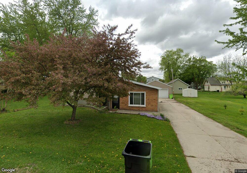
142 1st St Oakfield, WI 53065
Estimated Value: $176,000 - $215,000
2
Beds
2
Baths
984
Sq Ft
$193/Sq Ft
Est. Value
About This Home
This home is located at 142 1st St, Oakfield, WI 53065 and is currently estimated at $189,843, approximately $192 per square foot. 142 1st St is a home with nearby schools including Oakfield Elementary School, Oakfield High School, and St. Luke's Lutheran School.
Ownership History
Date
Name
Owned For
Owner Type
Purchase Details
Closed on
Aug 19, 2021
Sold by
Allender Alexander J
Bought by
Inks Brian R
Current Estimated Value
Home Financials for this Owner
Home Financials are based on the most recent Mortgage that was taken out on this home.
Original Mortgage
$96,000
Outstanding Balance
$87,294
Interest Rate
2.9%
Mortgage Type
New Conventional
Estimated Equity
$102,549
Purchase Details
Closed on
Mar 20, 2020
Sold by
Steiner Pamela J and Allender Pamela J
Bought by
Allender Alexander J
Home Financials for this Owner
Home Financials are based on the most recent Mortgage that was taken out on this home.
Original Mortgage
$90,250
Interest Rate
3.4%
Mortgage Type
New Conventional
Purchase Details
Closed on
May 17, 2006
Sold by
Knorr Leonard P
Bought by
Federal National Mortgage Association
Create a Home Valuation Report for This Property
The Home Valuation Report is an in-depth analysis detailing your home's value as well as a comparison with similar homes in the area
Home Values in the Area
Average Home Value in this Area
Purchase History
| Date | Buyer | Sale Price | Title Company |
|---|---|---|---|
| Inks Brian R | $120,000 | Schmitt Title Llc | |
| Allender Alexander J | $95,000 | None Available | |
| Federal National Mortgage Association | $63,100 | -- |
Source: Public Records
Mortgage History
| Date | Status | Borrower | Loan Amount |
|---|---|---|---|
| Open | Inks Brian R | $96,000 | |
| Previous Owner | Allender Alexander J | $90,250 |
Source: Public Records
Tax History Compared to Growth
Tax History
| Year | Tax Paid | Tax Assessment Tax Assessment Total Assessment is a certain percentage of the fair market value that is determined by local assessors to be the total taxable value of land and additions on the property. | Land | Improvement |
|---|---|---|---|---|
| 2024 | $2,365 | $124,900 | $14,500 | $110,400 |
| 2023 | $2,233 | $124,900 | $14,500 | $110,400 |
| 2022 | $2,464 | $124,900 | $14,500 | $110,400 |
| 2021 | $2,083 | $79,800 | $10,800 | $69,000 |
| 2020 | $2,002 | $79,800 | $10,800 | $69,000 |
| 2019 | $1,954 | $79,800 | $10,800 | $69,000 |
| 2018 | $1,941 | $79,800 | $10,800 | $69,000 |
| 2017 | $1,880 | $79,800 | $10,800 | $69,000 |
| 2016 | $1,857 | $79,800 | $10,800 | $69,000 |
| 2015 | $1,890 | $79,800 | $10,800 | $69,000 |
| 2014 | $1,930 | $79,800 | $10,800 | $69,000 |
| 2013 | $1,906 | $79,800 | $10,800 | $69,000 |
Source: Public Records
Map
Nearby Homes
- 229 S Elm St
- 136 E Waupun St
- 401 Leona Way
- W7316 County Road F
- N4749 Maple Dr
- 5106 County Road D
- 0 Thomaswood Trail
- 0 Hillcrest Rd Unit 50316117
- N5532 River Rd
- N11852 Lettau Dr
- 834 Evergreen Dr
- Lot 4 Brown Rd
- 635 Oak St
- W6936 Westwood Dr
- 0 Nelson Rd
- 414 Clark St
- N5825 Aidan Ct
- 0 Wild Ln W Unit NE50273484
- 0 Wild Ln W
- 0 Trowbridge Dr