
Seller's Agent in 2025
Mark Ellis
Ellis Group Property Management LLC
(856) 689-2729
1 in this area
114 Total Sales
*** Final & Best due 8/12. 8PM***
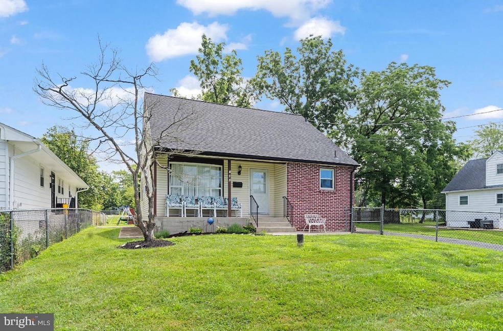
Welcome to 142 Broad Ave, Ewing, NJ!
Located just a short walk from The College of New Jersey and the bustling Campus Town filled with retail shops and dining, this charming Cape Cod-style home offers convenience, comfort, and classic appeal.
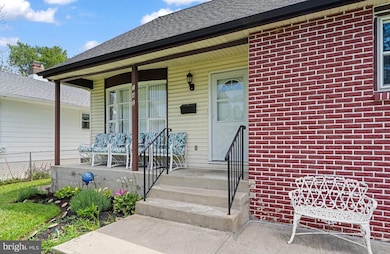
As you arrive, you’ll be greeted by a welcoming front porch and a private driveway, nestled in a peaceful, well-kept neighborhood.
Step inside to find:
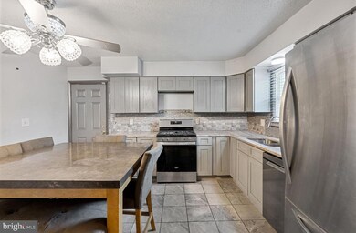
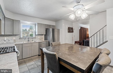
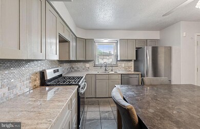
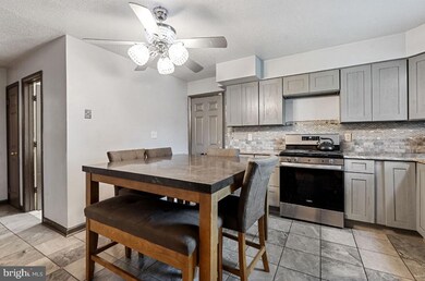
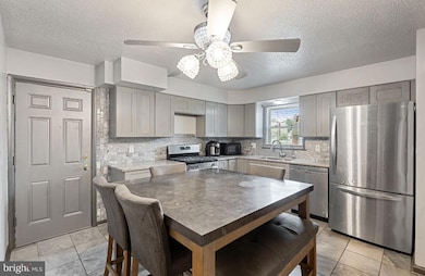
An Updated Eat-In Kitchen
Situated to the right of the foyer, the kitchen features modern cabinetry, sleek countertops, and stainless steel appliances — the perfect space to cook and gather.
Spacious Living & Dining Areas
To the left, a cozy yet open living room awaits — ideal for entertaining or relaxing. Toward the rear of the home, enjoy a formal dining room with plenty of natural light, offering views of the backyard.
Flexible Floor Plan
A full bathroom and one bedroom are located on the main floor, offering convenience and flexible living options. Upstairs, you’ll find two additional generously sized bedrooms.
Finished Basement
The lower level offers a finished space that can be used as a home office, gym, media room, or bonus living area. There’s also ample storage and a dedicated laundry area with washer and dryer included.
Outdoor Living
Enjoy the large, fully fenced backyard — ideal for summer gatherings, pets, or simply relaxing outdoors.
Prime Location
Minutes from I-295, close to the Hamilton Train Station, and near major shopping centers, schools, and entertainment venues.
⸻
Whether you’re a first-time buyer, investor, or looking to live near campus, 142 Broadway offers location, updates, and value.
*Please wear mask and booties (supplied at front door)
*Shed is excluded but negotiable.
Last Agent to Sell the Property
(856) 287-3558 markellis@go-erg.com Ellis Group Property Management LLC License #2075502 Listed on: 08/09/2025
Last Buyer's Agent
jleg0313@gmail.com Coldwell Banker Residential Brokerage-Princeton Jct
| Date | Type | Sale Price | Title Company |
|---|---|---|---|
| Deed | $350,000 | Old Republic National Title In | |
| Bargain Sale Deed | $145,900 | Sterling Title Agency | |
| Deed | $136,000 | -- | |
| Deed | $95,000 | -- |
| Date | Status | Loan Amount | Loan Type |
|---|---|---|---|
| Previous Owner | $336,000 | New Conventional | |
| Previous Owner | $143,960 | FHA | |
| Previous Owner | $91,000 | No Value Available |
| Date | Event | Price | List to Sale | Price per Sq Ft |
|---|---|---|---|---|
| 09/30/2025 09/30/25 | Sold | $350,000 | +9.4% | $273 / Sq Ft |
| 08/09/2025 08/09/25 | For Sale | $320,000 | -- | $249 / Sq Ft |
| Year | Tax Paid | Tax Assessment Tax Assessment Total Assessment is a certain percentage of the fair market value that is determined by local assessors to be the total taxable value of land and additions on the property. | Land | Improvement |
|---|---|---|---|---|
| 2025 | $7,221 | $183,600 | $47,800 | $135,800 |
| 2024 | $6,788 | $183,600 | $47,800 | $135,800 |
| 2023 | $6,788 | $183,600 | $47,800 | $135,800 |
| 2022 | $6,604 | $183,600 | $47,800 | $135,800 |
| 2021 | $6,443 | $183,600 | $47,800 | $135,800 |
| 2020 | $5,123 | $148,100 | $47,800 | $100,300 |
| 2019 | $4,989 | $148,100 | $47,800 | $100,300 |
| 2018 | $4,944 | $93,600 | $29,300 | $64,300 |
| 2017 | $5,059 | $93,600 | $29,300 | $64,300 |
| 2016 | $4,991 | $93,600 | $29,300 | $64,300 |
| 2015 | $4,924 | $93,600 | $29,300 | $64,300 |
| 2014 | $4,911 | $93,600 | $29,300 | $64,300 |
Seller's Agent in 2025
Mark Ellis
Ellis Group Property Management LLC
(856) 689-2729
1 in this area
114 Total Sales
J
Buyer's Agent in 2025
Jennifer Legore
Coldwell Banker Residential Brokerage-Princeton Jct
(609) 954-1876
4 in this area
90 Total Sales
Source: Bright MLS
MLS Number: NJME2063672
APN: 02-00242-0000-00003
Disclaimer: Certain information contained herein is derived from information provided by parties other than Homes.com. All information provided is deemed reliable, but is not guaranteed to be accurate and should be independently verified.
![]() The data relating to real estate for sale on this website appears in part through the BRIGHT Internet Data Exchange program, a voluntary cooperative exchange of property listing data between licensed real estate brokerage firms, and is provided by BRIGHT through a licensing agreement.
The data relating to real estate for sale on this website appears in part through the BRIGHT Internet Data Exchange program, a voluntary cooperative exchange of property listing data between licensed real estate brokerage firms, and is provided by BRIGHT through a licensing agreement.
Listing information is from various brokers who participate in the Bright MLS IDX program and not all listings may be visible on the site.
The property information being provided on or through the website is for the personal, non-commercial use of consumers and such information may not be used for any purpose other than to identify prospective properties consumers may be interested in purchasing.
Some properties which appear for sale on the website may no longer be available because they are for instance, under contract, sold or are no longer being offered for sale.
Property information displayed is deemed reliable but is not guaranteed.
Copyright 2026 Bright MLS, Inc.
Ask me questions while you tour the home.