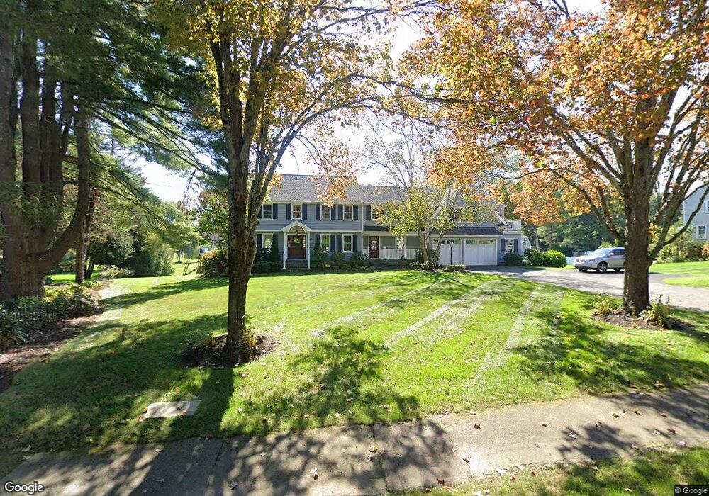
142 Fox Hill Rd Needham, MA 02492
Estimated Value: $1,835,000 - $2,219,222
4
Beds
4
Baths
1,412
Sq Ft
$1,449/Sq Ft
Est. Value
About This Home
This home is located at 142 Fox Hill Rd, Needham, MA 02492 and is currently estimated at $2,046,306, approximately $1,449 per square foot. 142 Fox Hill Rd is a home located in Norfolk County with nearby schools including Newman Elementary School, High Rock Middle School, and Pollard Middle School.
Ownership History
Date
Name
Owned For
Owner Type
Purchase Details
Closed on
Feb 28, 2007
Sold by
Colman Helen C and Colman James M
Bought by
Smith Kiran M and Smith Matthew F
Current Estimated Value
Home Financials for this Owner
Home Financials are based on the most recent Mortgage that was taken out on this home.
Original Mortgage
$920,000
Outstanding Balance
$557,168
Interest Rate
6.27%
Mortgage Type
Purchase Money Mortgage
Estimated Equity
$1,489,138
Create a Home Valuation Report for This Property
The Home Valuation Report is an in-depth analysis detailing your home's value as well as a comparison with similar homes in the area
Home Values in the Area
Average Home Value in this Area
Purchase History
| Date | Buyer | Sale Price | Title Company |
|---|---|---|---|
| Smith Kiran M | $1,150,000 | -- |
Source: Public Records
Mortgage History
| Date | Status | Borrower | Loan Amount |
|---|---|---|---|
| Open | Smith Kiran M | $920,000 | |
| Closed | Smith Kiran M | $250,000 |
Source: Public Records
Tax History
| Year | Tax Paid | Tax Assessment Tax Assessment Total Assessment is a certain percentage of the fair market value that is determined by local assessors to be the total taxable value of land and additions on the property. | Land | Improvement |
|---|---|---|---|---|
| 2025 | $19,119 | $1,803,700 | $898,200 | $905,500 |
| 2024 | $16,483 | $1,316,500 | $701,500 | $615,000 |
| 2023 | $16,470 | $1,263,000 | $701,500 | $561,500 |
| 2022 | $16,581 | $1,240,200 | $701,500 | $538,700 |
| 2021 | $16,160 | $1,240,200 | $701,500 | $538,700 |
| 2020 | $15,543 | $1,244,400 | $701,500 | $542,900 |
| 2019 | $14,079 | $1,136,300 | $701,500 | $434,800 |
| 2018 | $13,428 | $1,130,300 | $701,500 | $428,800 |
| 2017 | $12,846 | $1,080,400 | $701,500 | $378,900 |
| 2016 | $12,515 | $1,084,500 | $701,500 | $383,000 |
| 2015 | $12,244 | $1,084,500 | $701,500 | $383,000 |
| 2014 | $12,493 | $1,073,300 | $701,500 | $371,800 |
Source: Public Records
Map
Nearby Homes
- 53 Heather Ln
- 150 Laurel Dr
- 60 Sutton Rd
- 1011 Webster St
- 90 Norfolk St
- 569 Chestnut St
- 971 Webster St
- 47 Emerson Rd
- 68 Pleasant St Unit 68
- 100 Bradford St
- 126 Prince St
- 233 Warren St
- 957 South St
- 287 High Rock St
- 28 Green St
- 175 Schoolmaster Ln
- 37 Cottage Cir
- 37 Cottage Cir Unit 37
- 73 Maple St Unit 1
- 85 Schoolmaster Ln
- 156 Fox Hill Rd
- 130 Fox Hill Rd
- 101 Wildwood Dr
- 170 Fox Hill Rd
- 15 Wildwood Dr
- 93 Wildwood Dr
- 137 Fox Hill Rd
- 147 Fox Hill Rd
- 69 Wildwood Dr
- 41 Wildwood Dr
- 119 Fox Hill Rd
- 169 Fox Hill Rd
- 186 Fox Hill Rd
- 10 Wildwood Dr
- 107 Fox Hill Rd
- 94 Wildwood Dr
- 30 Wildwood Dr
- 1200 Webster St
- 179 Fox Hill Rd
- 108 Wildwood Dr
Your Personal Tour Guide
Ask me questions while you tour the home.