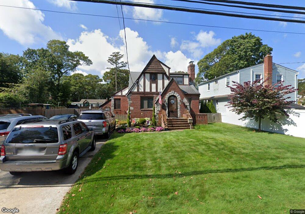
142 Livingston Ave Babylon, NY 11702
Estimated Value: $754,730 - $871,000
3
Beds
2
Baths
1,978
Sq Ft
$405/Sq Ft
Est. Value
About This Home
This home is located at 142 Livingston Ave, Babylon, NY 11702 and is currently estimated at $800,433, approximately $404 per square foot. 142 Livingston Ave is a home located in Suffolk County with nearby schools including Babylon Memorial Grade School, Babylon Elementary School, and Babylon High School.
Ownership History
Date
Name
Owned For
Owner Type
Purchase Details
Closed on
Apr 28, 2020
Sold by
Enkabian Armen and Enkabian Margaret
Bought by
Molnar Philip
Current Estimated Value
Purchase Details
Closed on
Dec 18, 2009
Sold by
Crockett Joan and Crockett Richard
Bought by
Enkababian Armen and Enkababian Margaret
Home Financials for this Owner
Home Financials are based on the most recent Mortgage that was taken out on this home.
Original Mortgage
$300,000
Interest Rate
4.85%
Mortgage Type
Purchase Money Mortgage
Create a Home Valuation Report for This Property
The Home Valuation Report is an in-depth analysis detailing your home's value as well as a comparison with similar homes in the area
Home Values in the Area
Average Home Value in this Area
Purchase History
| Date | Buyer | Sale Price | Title Company |
|---|---|---|---|
| Molnar Philip | $550,000 | None Available | |
| Enkababian Armen | $535,000 | -- | |
| Enkababian Armen | $535,000 | -- |
Source: Public Records
Mortgage History
| Date | Status | Borrower | Loan Amount |
|---|---|---|---|
| Previous Owner | Enkababian Armen | $300,000 |
Source: Public Records
Tax History Compared to Growth
Tax History
| Year | Tax Paid | Tax Assessment Tax Assessment Total Assessment is a certain percentage of the fair market value that is determined by local assessors to be the total taxable value of land and additions on the property. | Land | Improvement |
|---|---|---|---|---|
| 2024 | $15,662 | $4,800 | $260 | $4,540 |
| 2023 | $15,662 | $4,800 | $260 | $4,540 |
| 2022 | $9,582 | $4,800 | $260 | $4,540 |
| 2021 | $9,582 | $4,800 | $260 | $4,540 |
| 2020 | $10,552 | $4,800 | $260 | $4,540 |
| 2019 | $10,552 | $0 | $0 | $0 |
| 2018 | $9,814 | $4,800 | $260 | $4,540 |
| 2017 | $9,761 | $4,800 | $260 | $4,540 |
| 2016 | $9,527 | $4,800 | $260 | $4,540 |
| 2015 | -- | $4,800 | $260 | $4,540 |
| 2014 | -- | $4,800 | $260 | $4,540 |
Source: Public Records
Map
Nearby Homes
- 104 Frederick Ave
- 104 Ralph Ave
- 157 Cadman Ave
- 219 Litchfield Ave
- 91 Beverly Rd
- 29 Bailey Ave
- 79 Woodrow Pkwy
- 7 Bailey Ave
- 461 Ann St
- 102 Park Ave
- 246 Locust Ave
- 252 Locust Ave
- 144 Woodrow Pkwy
- 204 Millard Ave Unit 204
- 227 N Railroad Ave
- 5 Petersen Ct Unit 5
- 234 Millard Ave Unit 234
- 162 Millard Ave Unit 162
- 6 Waltie Ct
- 111 Little East Neck Rd
- 20 Marlborough Rd
- 132 Livingston Ave
- 28 Marlborough Rd
- 148 Livingston Ave
- 128 Livingston Ave
- 113 Frederick Ave
- 119 Frederick Ave
- 141 Livingston Ave
- 143 Livingston Ave
- 137 Livingston Ave
- 152 Livingston Ave
- 29 Marlborough Rd
- 107 Frederick Ave
- 133 Livingston Ave
- 124 Livingston Ave
- 17 Marlborough Rd
- 31 Marlborough Rd
- 127 Livingston Ave
- 156 Livingston Ave
- 120 Livingston Ave